|
||||||||||||
|
|
|
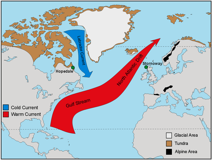
The Gulf Stream The Gulf Stream is one of the strong ocean currents that carries warm water from the sunny tropics to higher latitudes. The current stretches from the Gulf of Mexico up the East Coast of the United States, departs from North America south of the Chesapeake Bay, and heads across the Atlantic to the British Isles. The water within the Gulf Stream moves at the stately pace of 4 miles per hour. Even though the current cools as the water travels thousands of miles, it remains strong enough to moderate the Northern European climate.
Off the Atlantic seaboard of the United States, the Gulf Stream flows at a rate nearly 300 times faster than the typical flow of the Amazon River. The velocity of the current is fastest near the surface, with the maximum speed typically about 5.6 miles per hour (nine kilometers per hour). The average speed of the Gulf Stream, however, is four miles per hour (6.4 kilometers per hour). The current slows to a speed of about one mile per hour (1.6 kilometers per hour) as it widens to the north. The Gulf Stream transports nearly four billion cubic feet of water per second, an amount greater than that carried by all of the world's rivers combined.
Wind and the rotation of the Earth are important in determining the flow of surface currents and local areas of upwelling and downwelling, but the true driving force of deep water movement is thermohaline circulation.
Credit: British Society For Geomorphology Sometimes called the ocean conveyer belt, this mechanism is responsible for bringing the oxygen that sustains life to the deepest reaches of the sea, and in moving warmer waters from the tropics towards the poles. Movement of this conveyer belt depends on sinking of cold water in certain polar regions, thereby triggering the global thermohaline circulation.
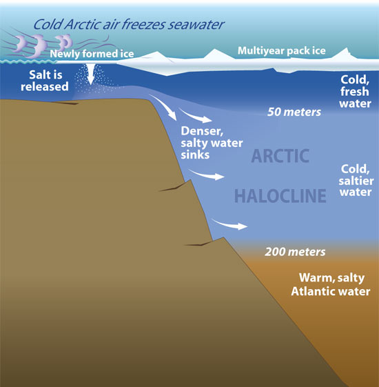
THE ARCTIC HALOCLIINE—When sea ice forms, it releases salt into surface waters. These waters become denser and sink to form the Arctic halocline—a layer of cold water that acts as barrier between sea ice and deeper warmer water that could melt the ice. (Illustration by Jayne Doucette, WHOI)
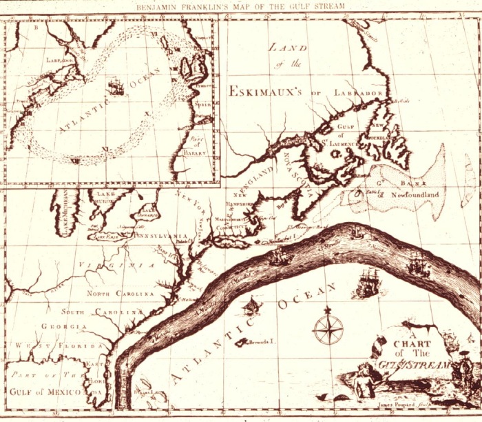
Benjamin Franklin's Chart of The Gulf Stream
The Gulf Stream, together with its northern extension towards Europe, the North Atlantic Drift, is a powerful, warm, and swift Atlantic ocean current that originates in the Gulf of Mexico, exits through the Strait of Florida, and follows the eastern coastlines of the United States and Newfoundland before crossing the Atlantic Ocean. At about 30°W, 40°N, it splits in two, with the northern stream crossing to northern Europe and the southern stream recirculating off West Africa. The Gulf Stream influences the climate of the east coast of North America from Florida to Newfoundland, and the west coast of Europe. This warm water then flows up the Norwegian coast, with a westward branch warming Greenland's tip, at 60°NIt keeps northern Europe about nine to eighteen degrees warmer in the winter than comparable latitudes elsewhere.
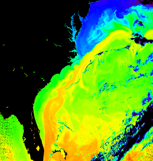
In this false-color Terra MODIS image, the Gulf Stream can be seen flowing to the northeast off of the United State’s eastern seaboard. This image is a false-color representation of water temperatures of the Atlantic, and since the Gulf Stream is a warm current, it shows up clearly against the surrounding waters. Temperatures are shown in a color range; progressing from low to high are purple, blue, turquoise, green yellow, orange, and red. Black represents a lack of data, and is used predominantly to represent land. The Gulf Stream shows up as a winding rope of orange and yellow against the cooler green and blue waters. NASA
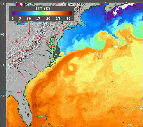
Pictured above is the East Coast of the United States, in grey, with the Gulf Stream, in orange, revealed through Sea Surface Temperature data (SST), made from the AVHRR (Advanced Very High Resolution Radiometer) sensor carried on a NOAA satellite. In this image, purple and blue represent the coldest temperatures (between 0-15 °C) and orange and red represents the warmest temperatures (between 22-32°C). The Gulf Stream is easily visible as the warmest water in the image and reaches from the Carribbean to as far north as Delaware. Credit: Gulf Stream Tutorial. Climate Change could alter this. Because freshwater is less dense than seawater, increased precipitation, melting of polar glaciers and ice caps could block the system by reducing the amount of cold water that sinks downwards.
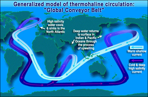
As water travels through the water cycle, some water will become part of The Global Conveyer Belt and can take up to 1,000 years to complete this global circuit. It represents in a simple way how ocean currents carry warm surface waters from the equator toward the poles and moderate global climate. NASA Graphic
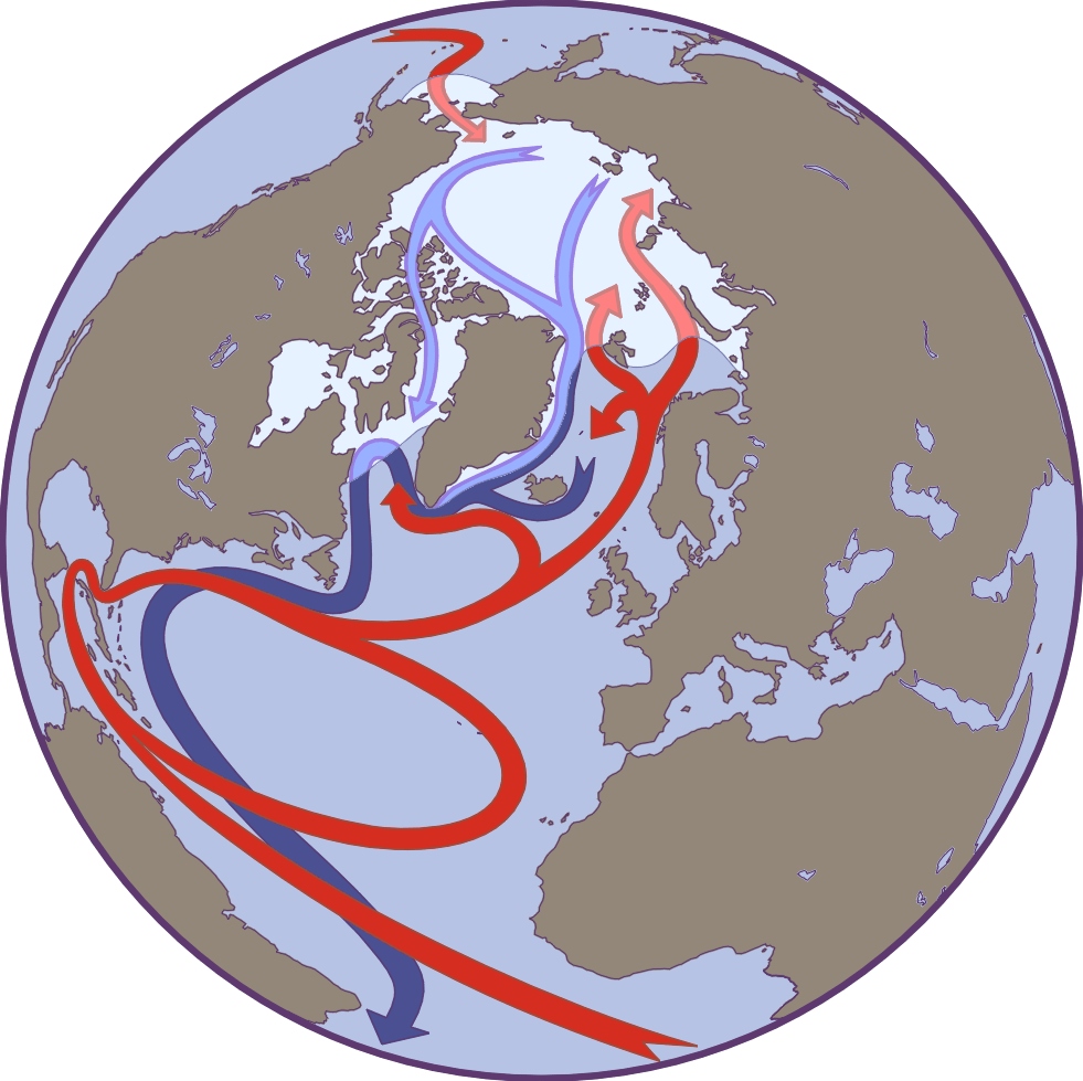
In the Atlantic, warm, high-salinity water flows northward in the Gulf Stream along the east coast of North America. Some of this water continues northeastward in the North Atlantic Current toward Iceland and Norway. Off the coast of Greenland, a portion of the surface water cools, becomes dense, and sinks. A further portion of surface water continues into the Arctic Ocean before also cooling and sinking. Together these sinking plumes off Greenland and in the Arctic form "deep water" that plays an important role in global oceanic circulation. Credit: NASA , UNEP, NSIDC,USGS |