Home Page Contact Racism Hunger
Site Map About Us Renewable Energy Religion
Corona Virus Climate Change Endangered Species War

Native Americans

Native Americans in the United States are the indigenous peoples from the regions of North America now encompassed by the continental United States, including parts of Alaska. They comprise a large number of distinct tribes, states, and ethnic groups, many of which are still enduring as political communities. There is a wide range of terms used, and some controversy surrounding their use: they are variously known as American Indians, Indians, Amerindians, Amerinds, or Indigenous, Aboriginal or Original Americans.

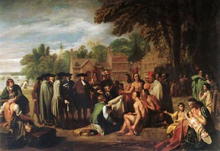
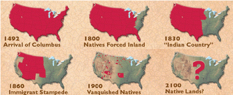
William Penn's Treaty with the Indians when he founded the Province of Pennsylvania in North America, 1771 Pennsylvania Academy of the Fine Arts, Philadelphia

The European colonization of the Americas nearly obliterated the populations and cultures of the Native Americans.

 During the 16th through 19th centuries, their populations were ravaged by conflicts with European explorers and colonists, disease, displacement, enslavement, internal warfare as well as high rate of intermarriage. Scholars now believe that, among the various contributing factors, epidemic disease was the overwhelming cause of the population decline of the American natives.

In the nineteenth century, the Westward expansion of the United States  compelled large numbers of Native Americans to resettle further west, often by force, almost always reluctantly. Under President Andrew Jackson, Congress passed the Indian Removal Act of 1830, which authorized the President to conduct treaties to exchange Native American land east of the Mississippi River for lands west of the river. As many as 100,000 Native Americans eventually relocated in the West as a result of this Indian Removal policy.

Conflicts, generally known as "Indian Wars", broke out between U.S. forces and many different tribes. U.S. government authorities entered numerous treaties during this period, but later abrogated many for various reasons. Well-known military engagements include the Native American victory at the Battle of Little Bighorn in 1876 and the massacre of Native Americans at Wounded Knee in 1890. This, together with the near-extinction of the American Bison that many tribes had lived on, set about the downturn of Prairie Culture that had developed around the use of the horse for hunting, travel and trading.

By conservative estimates, the  Native American population of the United states prior to European contact was greater than 12 million. According to 2003 United States Census Bureau estimates, a little over one third of the 2,786,652 Native Americans in the United States live in three states: California at 413,382, Arizona at 294,137 and Oklahoma at 279,559. 

Today there are 561 federally recognized tribal governments in the United States. These tribes possess the right to form their own government, to enforce laws (both civil and criminal), to tax, to establish membership, to license and regulate activities, to zone and to exclude persons from tribal territories. Limitations on tribal powers of self-government include the same limitations applicable to states; for example, neither tribes nor states have the power to make war, engage in foreign relations, or coin money.

The largest tribes in the U.S. by population are Navajo, Cherokee, Choctaw, Sioux, Chippewa, Apache, Lumbee, Blackfeet, Iroquois, and Pueblo.

Indian Reservations


1. ABSENTEE SHAWNEE *

2. ACOMA

3. AGUA CALIENTE

4. ALABAMA-COUSHATTA

5. ALABAMA-QUASSARTE CREEKS *

6. ALLEGANY

7. APACHE *

8. BAD RIVER

9. BARONA RANCH

10. BATTLE MOUNTAIN

11. BAY MILLS

12. BENTON PAIUTE

13. BERRY CREEK

14. BIG BEND

15. BIG CYPRESS

16. BIG LAGOON

17. BIG PINE

18. BIG VALLEY

19. BISHOP

20. BLACKFEET

21. BRIDGEPORT

22. BRIGHTON

23. BURNS PAIUTE COLONY

24. CABEZON

25. CADDO *

26. CAHUILLA

27. CAMPO

28. CAMP VERDE

29. CANONCITO

30. CAPITAN GRANDE

31. CARSON

32. CATAWBA

33. CATTARAUGUS

34. CAYUGA *

35. CEDARVILLE

36. CHEHALIS

37. CHEMEHUEVI

38. CHEROKEE * #

39. CHEYENNE-ARAPAHOE*

40. CHEYENNE RIVER

41. CHICKASAW *

42. CHITIMACHA

43. CHOCTAW * #

44. CITIZEN BAND OF POTAWATOMI *

45. COCHITI

46. COEUR D'ALENE

47. COLD SPRINGS

48. COLORADO RIVER

49. COLVILLE

50. COMANCHE *

51. COOS, LOWER UMPQUA & SIUSLAW

52. COQUILLE *

53. CORTINA

54. COUSHATTA

55. COW CREEK

56. CREEK *

57. CROW

58. CROW CREEK

59. CUYAPAIPE

60. DEER CREEK

61. DELAWARE *

62. DEVILS LAKE

63. DRESSLERVILLE COLONY

64. DRY CREEK

65. DUCKWATER

66. DUCK VALLEY

67. EASTERN SHAWNEE *

68. EAST COCOPAH

69. ELY COLONY

70. ENTERPRISE

71. FALLON

72. FLANDREAU INDIAN SCHOOL

73. FLATHEAD

74. FOND DU LAC

75. FORT APACHE

76. FORT BELKNAP

77. FORT BERTHOLD

78. FORT BIDWELL

79. FORT HALL

80. FORT INDEPENDENCE

81. FORT MCDERMITT

82. FORT MCDOWELL

83. FORT MOHAVE

84. FORT PECK

85. FORT YUMA

86. FT. SILL APACHE *

87. GILA BEND

88. GILA RIVER

89. GOSHUTE

90. GRANDE RONDE

91. GRAND PORTAGE

92. GRAND TRAVERSE

93. GREATER LEECH LAKE

94. GRINDSTONE

95. HANNAHVILLE

96. HAVASUPAI

97. HOH

98. HOLLYWOOD

99. HOOPA VALLEY

100. HOPI

101. HOULTON MALISEETS


102. HUALAPAI

103. INAJA

104. IOWA *

105. ISABELLA

106. ISLETA

107. JACKSON

108. JEMEZ

109. JICARILLA

110. KAIBAB

111. KALISPEL

112. KAW *

113. KIALEGEE CREEK *

114. KICKAPOO *

115. KIOWA *

116. KLAMATH *

117. KOOTENAI

118. L'ANSE

119. LAC COURTE OREILLES

120. LAC DU FLAMBEAU

121. LAC VIEUX DESERT

122. LAGUNA

123. LAS VEGAS

124. LAYTONVILLE

125. LA JOLLA

126. LA POSTA

127. LIKELY

128. LONE PINE

129. LOOKOUT

130. LOS COYOTES

131. LOVELOCK COLONY

132. LOWER BRULE

133. LOWER ELWAH

134. LOWER SIOUX

135. LUMMI

136. MAKAH

137. MANCHESTER

138. MANZANITA

139. MARICOPA

140. MASHANTUCKET PEQUOT

141. MATTAPONI +

142. MENOMINEE

143. MESCALERO

144. MIAMI *

145. MICCOSUKEE

146. MIDDLETOWN

147. MILLE LACS

148. MISSION

149. MOAPA

150. MODOC *

151. MOLE LAKE

152. MONTGOMERY CREEK

153. MORONGO

154. MUCKLESHOOT

155. NAMBE

156. NARRAGANSETT

157. NAVAJO

158. NETT LAKE

159. NEZ PERCE

160. NIPMOC-HASSANAMISCO +

161. NISQUALLY

162. NOOKSACK

163. NORTHERN CHEYENNE

164. NORTHWESTERN SHOSHONE

165. OIL SPRINGS

166. OMAHA

167. ONEIDA #

168. ONONDAGA

169. ONTONAGON

170. OSAGE

171. OTOE-MISSOURI *

172. OTTAWA *

173. OUT

174. OZETTE

175. PAIUTE

176. PALA

177. PAMUNKEY +

178. PASCUA YAQUI

179. PASSAMAQUODDY

180. PAUCATAUK PEQUOT +

181. PAUGUSETT +

182. PAWNEE *

183. PECHANGA

184. PENOBSCOT

185. PEORIA *

186. PICURIS

187. PINE RIDGE

188. POARCH CREEK

189. POJOAQUE

190. PONCA *

191. POOSEPATUCK +

192. PORT GAMBLE

193. PORT MADISON

194. POTAWATOMI #

195. PRAIRIE ISLE

196. PUERTOCITO

197. PUYALLUP

198. PYRAMID LAKE

199. QUAPAW *

200. QUILLAYUTE

201. QUINAULT

202. RAMAH

203. RAMONA

204. RED CLIFF

205. RED LAKE

206. RENO-SPARKS

207. RINCON

208. ROARING CREEK

209. ROCKY BOYS

210. ROSEBUD

211. ROUND VALLEY

212. RUMSEY

213. SAC AND FOX #

214. SALT RIVER

215. SANDIA

216. SANDY LAKE

217. SANTA ANA

218. SANTA CLARA

219. SANTA DOMINGO

220. SANTA ROSA

221. SANTA ROSA (NORTH)

222. SANTA YNEZ

223. SANTA YSABEL

224. SANTEE

225. SAN CARLOS

226. SAN FELIPE

227. SAN ILDEFONSO

228. SAN JUAN

229. SAN MANUAL

230. SAN PASQUAL

231. SAN XAVIER

232. SAUK SUIATTLE

233. SEMINOLE *

234. SENECA-CAYUGA *

235. SEQUAN

236. SHAGTICOKE +

237. SHAKOPEE

238. SHEEP RANCH

239. SHERWOOD VALLEY

240. SHINGLE SPRING

241. SHINNECOCK +

242. SHOALWATER

243. SHOSHONE

244. SILETZ

245. SISSETON

246. SKOKOMISH

247. SKULL VALLEY

248. SOBOBA

249. SOUTHERN UTE

250. SPOKANE

251. SQUAXON ISLAND

252. ST. CROIX

253. ST. REGIS

254. STANDING ROCK

255. STEWARTS POINT

256. STOCKBRIDGE MUNSEE

257. SUMMIT LAKE

258. SUSANVILLE

259. SWINOMISH

260. TAOS

261. TE-MOAK

262. TESUQUE

263. TEXAS KICKAPOO

264. TOHONO O'ODHAM

265. TONAWANDA

266. TONIKAWA *

267. TORRES MARTINEZ

268. TOULUMNE

269. TRINDAD

270. TULALIP

271. TULE RIVER

272. TUNICA-BILOXI

273. TURTLE MOUNTAINS

274. TUSCARORA

275. TWENTYNINE PALMS

276. UMATILLA

277. UINTAH AND OURAY

278. UNITED KEETOOWAH BAND OF CHEROKEE *

279. UPPER SIOUX

280. UPPER SKAGIT

281. UTE MOUNTAIN

282. VERMILION LAKE

283. VIEJAS

284. WALKER RIVER

285. WARM SPRINGS

286. WASHOE

287. WEST COCOPAH

288. WHITE EARTH

289. WICHITA *

290. WIND RIVER

291. WINNEBAGO #

292. WINNEMUCCA

293. WOODFORD INDIAN COMMUNITY

294. WYANDOTTE *

295. XL RANCH

296. YAKAMA

297. YANKTON

298. YAVAPAI

299. YERINGTON

300. YOMBA

301. YSLETA DEL SUR

302. YUROK

303. ZIA

304. ZUNI

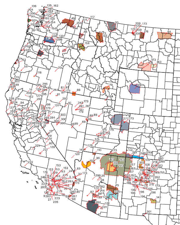
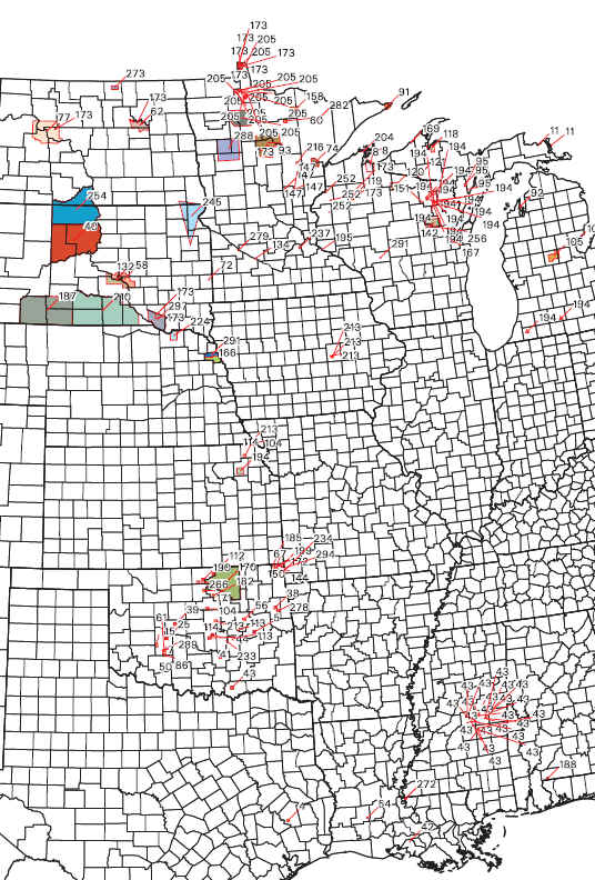
http://www.nps.gov/nagpra/DOCUMENTS/RESERV.PDF

An Indian reservation is an area of land managed by a Native American tribe under the United States Department of the Interior's Bureau of Indian Affairs. There are about 310 Indian reservations in the United States, meaning not all of the country's 550-plus recognized tribes have a reservation — some tribes have more than one reservation, some share reservations, while others have none.

 The collective geographical area of all reservations is 55.7 million acres (225,410 km²), representing 2.3% of the area of the United States (2,379,400,204 acres; 9,629,091 km²). Twelve Indian reservations are larger than the state of Rhode Island (776,960 acres; 3,144 km²) and nine reservations larger than Delaware (1,316,480 acres; 5,327 km²). The territory of the Navajo Nation compares in size to West Virginia. Reservations are unevenly distributed throughout the country; the majority are west of the Mississippi River and occupy lands that were first reserved by treaty or 'granted' from the public domain