|
||||||||||||
|
|
|
El Niño and La Niña
El Niño and La Niña Effects on Global Temperature
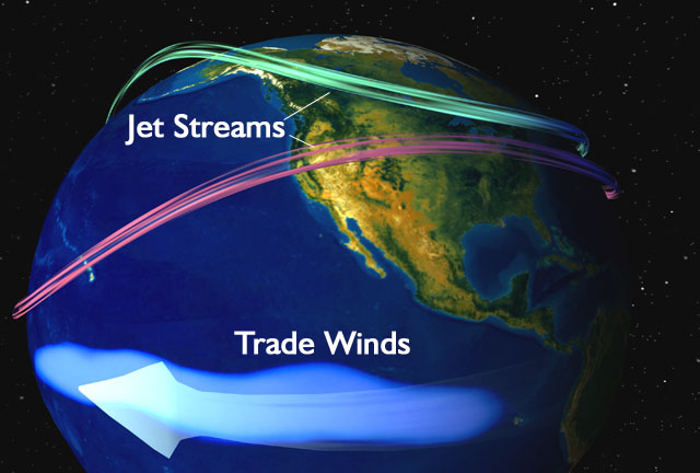
Normal Ocean conditions El Niño/La Niña is a naturally occurring 2-7 year cycle of the ocean-atmosphere system in the Tropical Pacific having important consequences for weather and climate around the globe.
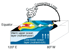
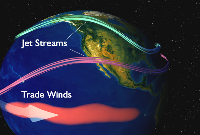
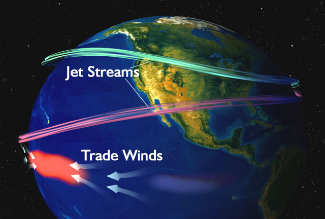
El Niño (Spanish for the little boy or the Christ Child) is a disruption of the ocean atmosphere system in the tropical Pacific. El Nino, an abnormal warming of surface ocean waters in the eastern tropical Pacific, is one part of what's called the Southern Oscillation. The Southern Oscillation is the see-saw pattern of reversing surface air pressure between the eastern and western tropical Pacific; when the surface pressure is high in the eastern tropical Pacific it is low in the western tropical Pacific, and vice-versa. Because the ocean warming and pressure reversals are, for the most part, simultaneous, scientists call this phenomenon the El Nino/Southern Oscillation or ENSO for short. Normally trade winds move westward carrying warm water to Australia. Cooler water can upwell along the South American coast. This cool water carries nutrients that support large fish populations in the region. Every three to seven years, these trade winds die and the warm water that was once pushed westward is allowed to shift back towards South America. South American fisherman have given this phenomenon the name El Niño, which is Spanish for "The Christ Child," because it comes about the time of the celebration of the birth of the Christ Child-Christmas.
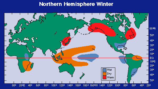
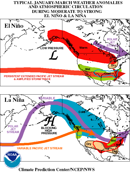
El Niño disrupts the ocean-atmosphere system in the tropical Pacific having important consequences for weather around the globe. Among these consequences are increased rainfall across the southern tier of the US and in Peru, which has caused destructive flooding, and drought in the West Pacific, sometimes associated with devastating brush fires in Australia.
El Nino conditions
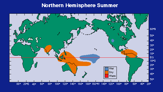
Precipitation anomalies during El Niño in Summer and Winter
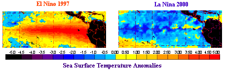
La Niña (Spanish for the little girl) is essentially the opposite of El Nino The ocean becomes much cooler than normal. Although, La Niña is not as well understood as El Niño, it is thought to occur due to an increase in the strength of the trade winds This increases the amount of cooler water that flows toward the west coast of South American and reduces water temperatures. Global climate La Niña impacts tend to be opposite those of El Niño impacts. In the tropics, ocean temperature variations in La Niña tend to be opposite those of El Niño.
La Nina conditions Environment Canada graphics
The image shows what happens when a very strong El Nino strikes surface waters in the Central equatorial Pacific Ocean. The sequence shows warm water anomalies (red) develop in the Central Pacific Ocean. Winds that normally blow in a westerly direction weaken allowing the easterly winds to push the warm water up against the South American Coast.
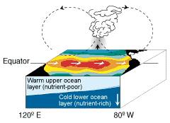
This image shows colder than normal water (blue) anomalies in the central equatorial Pacific associated with La Nina. Stronger than normal trade winds bring cold water up to the surface of the ocean.
This image shows the current El Nino's split personality. Warm waters develop in the central Pacific Ocean. In this case, the warm water anomalies tend to stay in place in the central Pacific.
Normal Ocean conditions
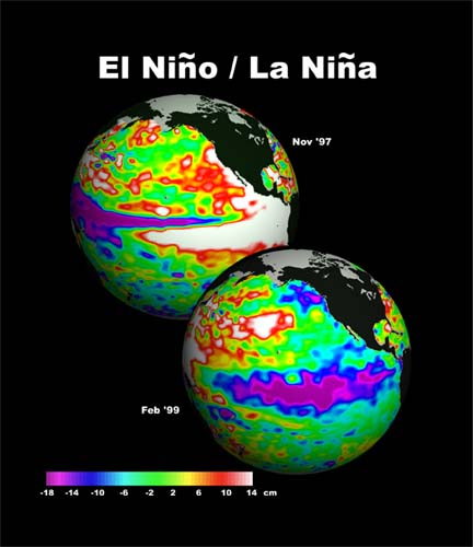
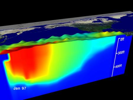
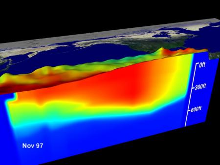
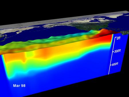
The images show sea surface topography from NASA's TOPEX satellite, sea surface temperature's from NOAA's AVHRR satellite sensor and sea temperature below the surface as measured by NOAA's network of TAO moored buoys. The three dimensional relief map shows a sea level rise along the Equator in the eastern Pacific Ocean of up to 34 centimeters with the red colors indicating an associated change in sea surface temperature of up to 5.4 degrees Celsius.
El Nino conditions
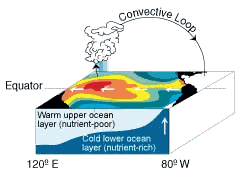
The sea temperature below the surface illustrates how the thermocline (the boundary between warm and cold sea water at 20 degrees Celcius) is flattened out by El Niño. These images are beneath Sea Views of sea surface height (represented by the bumps) and sea temperature (represented by the color). Red is 30 degrees C and blue is 8 degrees C. The thermocline is the border between the dark blue at the bottom and the cyan. The thermocline exists at 20 degrees C. Data from 1/1/97 to 3/10/98. La Nina conditions
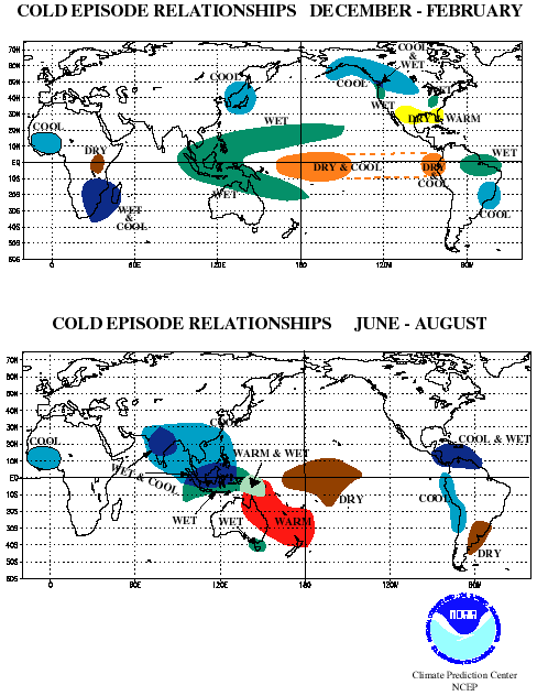
During La Niña
episodes rainfall is enhanced across the western equatorial Pacific, Indonesia
and the Philippines and is nearly absent across the eastern equatorial Pacific.
Elsewhere, wetter than normal conditions tend to be observed during
December-February (DJF) over northern South America and southern Africa, and
during June-August (JJA) over southeastern Australia. Drier than normal
conditions are generally observed along coastal Ecuador, northwestern Peru and
equatorial eastern Africa during DJF, and over southern Brazil and central
Argentina during JJA.
Credit: NOAA, NASA, Environment Canada |