The
ingredients for a hurricane include a pre-existing weather disturbance,
warm tropical oceans, moisture, and relatively light winds aloft. If the
right conditions persist long enough, they can combine to produce the
violent winds, incredible waves, torrential rains, and floods we associate
with this phenomenon.
Each year, an
average of eleven tropical storms develop over the Atlantic Ocean,
Caribbean Sea, and Gulf of Mexico. Many of these remain over the ocean and
never impact the U.S. coastline. Six of these storms become hurricanes
each year. In an average 3-year period, roughly five hurricanes strike the
US coastline, killing approximately 50 to 100 people anywhere from Texas
to Maine. Of these, two are typically "major" or "intense" hurricanes (a
category 3 or higher storm on the Saffir-Simpson Hurricane Scale).
What is a
Hurricane? A hurricane is a
type of tropical cyclone, which is a generic term for a low pressure
system that generally forms in the tropics. The cyclone is accompanied by
thunderstorms and, in the Northern Hemisphere, a counterclockwise
circulation of winds near the earth's surface. Tropical cyclones are
classified as follows:
Tropical Depression An organized system
of clouds and thunderstorms with a defined surface circulation and maximum
sustained winds* of 38 mph (33 kt**) or less
Tropical Storm An organized system of strong thunderstorms with a defined surface
circulation and maximum sustained winds of 39-73 mph (34-63 kt)
Hurricane An intense tropical weather system of strong thunderstorms with a
well-defined surface circulation and maximum sustained winds of 74 mph (64
kt) or higher.
Hurricanes are categorized according to the strength of their winds
using the Saffir-Simpson Hurricane Scale. A Category 1 storm has the
lowest wind speeds, while a Category 5 hurricane has the strongest.
These are relative terms, because lower category storms can sometimes
inflict greater damage than higher category storms, depending on where
they strike and the particular hazards they bring. In fact, tropical
storms can also produce significant damage and loss of life, mainly due to
flooding.
Tropical Cyclone
Introduction
A tropical cyclone is a
warm-core, low pressure system without any "front" attached, that develops
over the tropical or subtropical waters, and has an organized circulation.
Depending upon location, tropical cyclones have different names around the
world. In the:
Atlantic/Eastern Pacific
Oceans - hurricanes
Western Pacific -
typhoons
Indian Ocean -
cyclones
Regardless of what they are
called, there are several favorable environmental conditions that must be
in place before a tropical cyclone can form. They are:
Warm ocean waters (at
least 80°F / 27°C)
throughout a depth of about 150 ft. (46
m).
An atmosphere which
cools fast enough with height such that it is potentially unstable to
moist convection.
Relatively moist air
near the mid-level of the troposphere (16,000 ft. / 4,900 m).
Generally a minimum
distance of at least 300 miles (480 km)
from the equator.
A pre-existing
near-surface disturbance.
Low values (less than
about 23 mph / 37
kph) of vertical wind shear between the surface and the upper
troposphere. Vertical wind shear is the change in wind speed with
height.
The seedlings of tropical
cyclones, called "disturbances", can come from:
Easterly Waves: Also called tropical waves, this is an inverted
trough of low pressure moving generally westward in the tropical
easterlies. A trough is defined as a region of relative low pressure.
The majority of tropical cyclones form from easterly waves.
West
African Disturbance Line (WADL): This is a line of convection
(similar to a squall line) which forms over West Africa and moves into
the Atlantic Ocean. WADL's usually move faster than tropical waves.
TUTT:
A TUTT (Tropical Upper Tropospheric Trough) is a trough, or cold core
low in the upper atmosphere, which produces convection. On occasion, one
of these develops into a warm-core tropical cyclone.
Old
Frontal Boundary: Remnants of a polar front can become lines of
convection and occasionally generate a tropical cyclone. In the Atlantic
Ocean storms, this will occur early or late in the hurricane season in
the Gulf of Mexico or Caribbean Sea.
Once a disturbance forms
and sustained convection develops, it can become more organized under
certain conditions. If the disturbance moves or stays over warm water (at
least 80°F), and upper level winds remain weak, the disturbance can become
more organized, forming a depression.
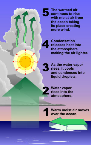
The warm water is one of
the most important keys as it is water that powers the tropical cyclone
(see image above right). As water vapor (water in the gaseous state)
rises, it cools. This cooling causes the water vapor to condense into a
liquid we see as clouds. In the process of condensation, heat is released.
This heat warms the atmosphere making the air lighter still which then
continues to rise into the atmosphere. As it does, more air moves in near
the surface to take its place which is the strong wind we feel from these
storms.
Therefore, once the eye of
the storm moves over land will begin to weaken rapidly, not because of
friction, but because the storm lacks the moisture and heat sources that
the ocean provided. This depletion of moisture and heat hurts the tropical
cyclone's ability to produce thunderstorms near the storm center. Without
this convection, the storm rapidly diminishes.
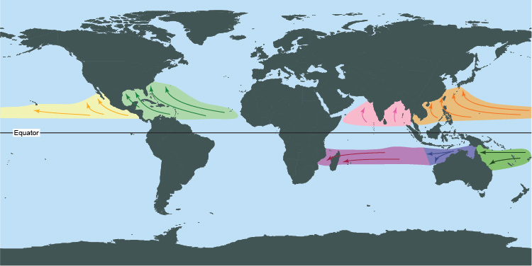
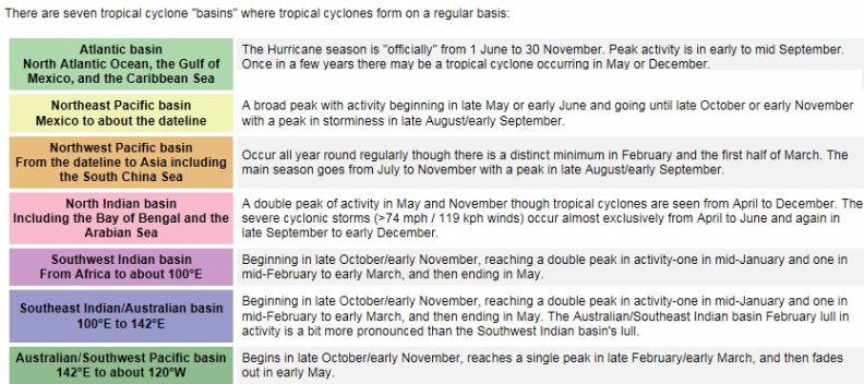
Tropical Cyclone Formation
Basin
Given that sea surface
temperatures need to be at least 80°F (27°C) for tropical cyclones form,
it is natural that they form near the equator. However, with only the
rarest of occasions, these storms do not form within 5° latitude of the
equator. This is due to the lack of sufficient Coriolis
Force, the force that causes the cyclone to spin. However, tropical
cyclones form in seven regions around the world.
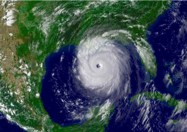
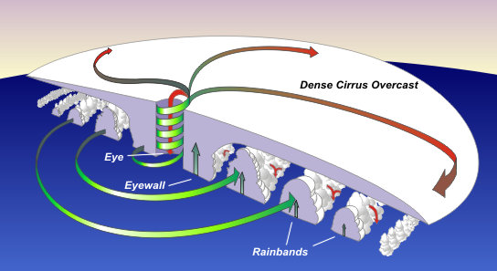
Tropical Cyclone Structure
The main parts of a
tropical cyclone are the rainbands, the eye, and the eyewall. Air spirals
in toward the center in a counter-clockwise pattern in the northern
hemisphere (clockwise in the southern hemisphere), and out the top in the
opposite direction. In the very center of the storm, air sinks, forming an
"eye" that is mostly cloud-free.
The Eye
The hurricane's center is a
relatively calm, generally clear area of sinking air and light winds that
usually do not exceed 15 mph (24
kph) and is typically 20-40 miles (32-64
km) across. An eye will usually develop when the maximum sustained
wind speeds go above 74 mph (119 kph) and is the calmest part of the
storm.
But why does an eye form?
The cause of eye formation is still not fully understood. It probably has
to do with the combination of "the conservation of angular momentum" and
centrifugal force. The conservation of angular momentum means is objects
will spin faster as they move toward the center of circulation. So air
increases it speed as it heads toward the center of the tropical cyclone.
One way of looking at this is watching figure skaters spin. The closer
they hold their hands to the body, the faster they spin. Conversely, the
farther the hands are from the body the slower they spin. In tropical
cyclone, as the air moves toward the center, the speed must increase.
However, as the speed
increases, an outward-directed force, called the centrifugal force, occurs
because the wind's momentum wants to carry the wind in a straight line.
Since the wind is turning about the center of the tropical cyclone, there
is a pull outward. The sharper the curvature, and/or the faster the
rotation, the stronger is the centrifugal force.
Around 74 mph (119 kph) the
strong rotation of air around the cyclone balances inflow to the center,
causing air to ascend about 10-20 miles (16-32 km) from the center forming
the eyewall. This strong rotation also creates a vacuum of air at the
center, causing some of the air flowing out the top of the eyewall to turn
inward and sink to replace the loss of air mass near the center.
This sinking air suppresses
cloud formation, creating a pocket of generally clear air in the center.
People experiencing an eye passage at night often see stars. Trapped birds
are sometimes seen circling in the eye, and ships trapped in a hurricane
report hundreds of exhausted birds resting on their decks. The landfall of
hurricane Gloria (1985) on southern New England was accompanied by
thousands of birds in the eye.
The sudden change of very
strong winds to a near calm state is a dangerous situation for people
ignorant about a hurricane's structure. Some people experiencing the light
wind and fair weather of an eye may think the hurricane has passed, when
in fact the storm is only half over with dangerous eyewall winds
returning, this time from the opposite direction within a few minutes.
The
Eyewall
Where the strong wind gets
as close as it can is the eyewall. The eyewall consists of a ring of tall
thunderstorms that produce heavy rains and usually the strongest winds.
Changes in the structure of the eye and eyewall can cause changes in the
wind speed, which is an indicator of the storm's intensity. The eye can
grow or shrink in size, and double (concentric) eyewalls can form.
Rainbands
Curved bands of clouds and
thunderstorms that trail away from the eye wall in a spiral fashion. These
bands are capable of producing heavy bursts of rain and wind, as well as
tornadoes. There are sometimes gaps in between spiral rain bands where no
rain or wind is found.
In fact, if one were to
travel between the outer edge of a hurricane to its center, one would
normally progress from light rain and wind, to dry and weak breeze, then
back to increasingly heavier rainfall and stronger wind, over and over
again with each period of rainfall and wind being more intense and lasting
longer.
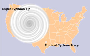
Tropical
Cyclone Size
The relative sizes of the largest and smallest tropical cyclones on
record as compared to the United States.
Typical hurricane strength
tropical cyclones are about 300 miles (483 km) wide although they can vary
considerably. as shown in the two enhanced satellite images below. Size is
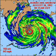
not necessarily an indication of hurricane intensity. Hurricane Andrew
(1992), the second most devastating hurricane to hit the United States,
next to Katrina in 2005, was a relatively small hurricane.
On record,
Typhoon Tip (1979) was the largest storms with gale force winds (39
mph/63 km/h) that extended out for 675 miles (1087 km) in radius in the
Northwest Pacific on 12 October, 1979. The smallest storm was
Tropical Cyclone Tracy with gale force winds that only extended 30
miles (48 km) radius when it struck Darwin, Australia, on December 24,
1974.
However, the hurricane's
destructive winds and rains cover a wide swath. Hurricane-force winds can
extend outward more than 150 miles (242 km) for a large one. The area over
which tropical storm-force winds occur is even greater, ranging as far out
as almost 300 miles (483 km) from the eye of a large hurricane.
The strongest hurricane on
record for the Atlantic Basin is Hurricane Wilma (2005). With a central
pressure of 882 mb (26.05"), Wilma produced
sustained winds of 175 mph (280 km/h).
Storm Surge
Along the coast, storm surge
is often the greatest threat to life and property from a hurricane. In the
past, large death tolls have resulted from the rise of the ocean
associated with many of the major hurricanes that have made landfall.
Hurricane Katrina (2005) is a prime example of the damage and devastation
that can be caused by surge. At least 1500 persons lost their lives during
Katrina and many of those deaths occurred directly, or indirectly, as a
result of storm surge.
Storm Surge vs. Storm Tide
STORM SURGE is an
abnormal rise of water generated by a storm, over and above the
predicted astronomical tide.
STORM TIDE is the water
level rise during a storm due to the combination of storm surge and the
astronomical tide.
Storm surge is an abnormal
rise of water generated by a storm, over and above the predicted
astronomical tides. Storm surge should not be confused with storm tide,
which is defined as the water level rise due to the combination of storm
surge and the astronomical tide. This rise in water level can cause
extreme flooding in coastal areas particularly when storm surge coincides
with normal high tide, resulting in storm tides reaching up to 20 feet or
more in some cases.
Storm Surge vs. Storm Tide
Factors Impacting Surge
Storm surge is produced by
water being pushed toward the shore by the force of the winds moving
cyclonically around the storm. The impact on surge of the low pressure
associated with intense storms is minimal in comparison to the water being
forced toward the shore by the wind.
Wind and Pressure Components of Hurricane Storm Surge
The maximum potential storm surge for a particular location depends on a
number of different factors. Storm surge is a very complex phenomenon
because it is sensitive to the slightest changes in storm intensity,
forward speed, size (radius of maximum winds-RMW), angle of approach to
the coast, central pressure (minimal contribution in comparison to the
wind), and the shape and characteristics of coastal features such as bays
and estuaries.
Other factors which can impact storm surge are the width and slope of the
continental shelf. A shallow slope will potentially produce a greater
storm surge than a steep shelf. For example, a Category 4 storm hitting
the Louisiana coastline, which has a very wide and shallow continental
shelf, may produce a 20-foot storm surge, while the same hurricane in a
place like Miami Beach, Florida, where the continental shelf drops off
very quickly, might see an 8 or 9-foot surge.
Adding to
the destructive power of surge, battering waves may increase damage to
buildings directly along the coast. Water weighs approximately 1,700
pounds per cubic yard; extended pounding by frequent waves can demolish
any structure not specifically designed to withstand such forces. The two
elements work together to increase the impact on land because the surge
makes it possible for waves to extend inland.
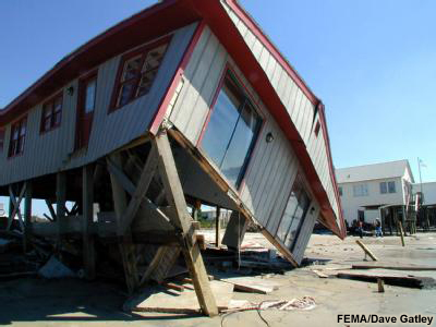
Although elevated, this house in North Carolina could not withstand the 15
ft (4.5 m) of storm surge that came with Hurricane Floyd (1999)
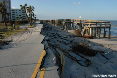
Additionally, currents created by tides combine with the waves to severely
erode beaches and coastal highways. Buildings that survive hurricane winds
can be damaged if their foundations are undermined and weakened by
erosion.
Beachfront road and boardwalk damaged by Hurricane Jeanne (2004)
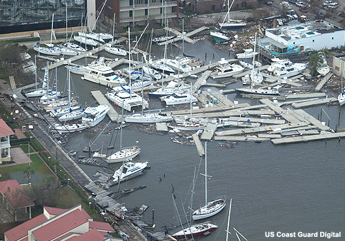
In confined harbors, the combination of storm tides, waves, and currents
can also severely damage marinas and boats. In estuaries and bayous, salt
water intrusion endangers the public health, kills vegetation, and can
send animals, such as snakes and alligators, fleeing from flooded areas.
Damaged boats in a marina
Tropical Cyclone
Classification
Tropical cyclones with an
organized system of clouds and thunderstorms with a defined circulation,
and maximum sustained winds of 38
mph
(61 kph) or less are
called "tropical depressions". Once the tropical cyclone reaches winds of
at least 39 mph (63 kph) they are typically called a "tropical storm" and
assigned a name.
If maximum sustained winds
reach 74 mph (119 kph), the cyclone is called:
A
hurricane
in the North Atlantic Ocean, the Northeast Pacific Ocean east of the
dateline, and the South Pacific Ocean east of 160°E, (The word hurricane
comes from the Carib Indians of the West Indies, who called this storm a
huracan. Supposedly, the ancient Tainos tribe of Central America
called their god of evil "Huracan". Spanish colonists modified the word
to hurricane.),
A
typhoon
in the Northwest Pacific Ocean west of the dateline (super
typhoon if the maximum sustained winds are at least 150 mph / 241
kph),
A
severe tropical cyclone in the Southwest Pacific Ocean west of
160°E or Southeast Indian Ocean east of 90°E,
A
severe cyclonic storm in the North Indian Ocean, and
Just a
tropical cyclone in the Southwest Indian Ocean.
Hurricanes are further
classified according to their wind speed. The
Saffir-Simpson Hurricane Wind Scale is a 1-5 rating based on the
hurricane's present intensity. This scale only addresses the wind speed
and does not take into account the potential for other hurricane-related
impacts, such as storm surge, rainfall-induced floods, and tornadoes.
Earlier versions of this
scale – known as the Saffir-Simpson Hurricane Scale – incorporated central
pressure and storm surge as components of the categories. However,
hurricane size (extent of hurricane-force winds), local bathymetry (depth
of near-shore waters), topography, the hurricane's forward speed and angle
to the coast also affect the surge that is produced.
For example, the very large
Hurricane Ike (with hurricane force winds extending as much as 125 miles
(200 kilometers) from the center) in 2008 made landfall in Texas as a
Category 2 hurricane and had peak storm surge values of about 20 feet (6
meters). In contrast, tiny Hurricane Charley (with hurricane force winds
extending at most 25 miles (40 kilometers) from the center) struck Florida
in 2004 as a Category 4 hurricane and produced a peak storm surge of only
about 7 feet (2.1 meters). These storm surge values were substantially
outside of the ranges suggested in the original scale.
To help reduce public
confusion about the impacts associated with the various hurricane
categories as well as to provide a more scientifically defensible scale,
the storm surge ranges, flooding impact and central pressure statements
were removed from the scale and only peak winds are now employed.
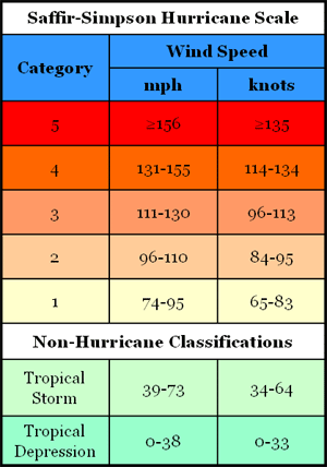
Saffir-Simpson Hurricane Scale
Category One Hurricane (Sustained
winds 74-95 mph, 64-82 kt, or 119-153 km/hr).
Very dangerous winds will produce some damage
People, livestock, and pets
struck by flying or falling debris could be injured or killed. Older
(mainly pre-1994 construction) mobile homes could be destroyed, especially
if they are not anchored properly as they tend to shift or roll off their
foundations. Newer mobile homes that are anchored properly can sustain
damage involving the removal of shingle or metal roof coverings, and loss
of vinyl siding, as well as damage to carports, sunrooms, or lanais. Some
poorly constructed frame homes can experience major damage, involving loss
of the roof covering and damage to gable ends as well as the removal of
porch coverings and awnings. Unprotected windows may break if struck by
flying debris. Masonry chimneys can be toppled. Well-constructed frame
homes could have damage to roof shingles, vinyl siding, soffit panels, and
gutters. Failure of aluminum, screened-in, swimming pool enclosures can
occur. Some apartment building and shopping center roof coverings could be
partially removed. Industrial buildings can lose roofing and siding
especially from windward corners, rakes, and eaves. Failures to overhead
doors and unprotected windows will be common. Windows in high-rise
buildings can be broken by flying debris. Falling and broken glass will
pose a significant danger even after the storm. There will be occasional
damage to commercial signage, fences, and canopies. Large branches of
trees will snap and shallow rooted trees can be toppled. Extensive damage
to power lines and poles will likely result in power outages that could
last a few to several days. Hurricane Dolly (2008) is an example of a
hurricane that brought Category 1 winds and impacts to South Padre Island,
Texas.
Category Two Hurricane (Sustained
winds 96-110 mph, 83-95 kt, or 154-177 km/hr).
Extremely dangerous winds will cause extensive damage
There is a substantial risk of
injury or death to people, livestock, and pets due to flying and falling
debris. Older (mainly pre-1994 construction) mobile homes have a very high
chance of being destroyed and the flying debris generated can shred nearby
mobile homes. Newer mobile homes can also be destroyed. Poorly constructed
frame homes have a high chance of having their roof structures removed
especially if they are not anchored properly. Unprotected windows will
have a high probability of being broken by flying debris. Well-constructed
frame homes could sustain major roof and siding damage. Failure of
aluminum, screened-in, swimming pool enclosures will be common. There will
be a substantial percentage of roof and siding damage to apartment
buildings and industrial buildings. Unreinforced masonry walls can
collapse. Windows in high-rise buildings can be broken by flying debris.
Falling and broken glass will pose a significant danger even after the
storm. Commercial signage, fences, and canopies will be damaged and often
destroyed. Many shallowly rooted trees will be snapped or uprooted and
block numerous roads. Near-total power loss is expected with outages that
could last from several days to weeks. Potable water could become scarce
as filtration systems begin to fail. Hurricane Frances (2004) is an
example of a hurricane that brought Category 2 winds and impacts to
coastal portions of Port St. Lucie, Florida with Category 1 conditions
experienced elsewhere in the city.
Category Three Hurricane
(Sustained winds 111-130 mph, 96-113 kt, or 178-209 km/hr).
Devastating damage will
occur
There is a high risk of injury or
death to people, livestock, and pets due to flying and falling debris.
Nearly all older (pre-1994) mobile homes will be destroyed. Most newer
mobile homes will sustain severe damage with potential for complete roof
failure and wall collapse. Poorly constructed frame homes can be destroyed
by the removal of the roof and exterior walls. Unprotected windows will be
broken by flying debris. Well-built frame homes can experience major
damage involving the removal of roof decking and gable ends. There will be
a high percentage of roof covering and siding damage to apartment
buildings and industrial buildings. Isolated structural damage to wood or
steel framing can occur. Complete failure of older metal buildings is
possible, and older unreinforced masonry buildings can collapse. Numerous
windows will be blown out of high-rise buildings resulting in falling
glass, which will pose a threat for days to weeks after the storm. Most
commercial signage, fences, and canopies will be destroyed. Many trees
will be snapped or uprooted, blocking numerous roads. Electricity and
water will be unavailable for several days to a few weeks after the storm
passes. Hurricane Ivan (2004) is an example of a hurricane that brought
Category 3 winds and impacts to coastal portions of Gulf Shores, Alabama
with Category 2 conditions experienced elsewhere in this city.
Category Four Hurricane
(Sustained winds 131-155 mph, 114-135 kt, or 210-249 km/hr).
Catastrophic damage will
occur
There is a very high risk of injury
or death to people, livestock, and pets due to flying and falling debris.
Nearly all older (pre-1994) mobile homes will be destroyed. A high
percentage of newer mobile homes also will be destroyed. Poorly
constructed homes can
Category Five Hurricane (Sustained
winds greater than 155 mph, greater than 135 kt, or greater than 249
km/hr).
Catastrophic damage will
occur
People, livestock, and pets are at
very high risk of injury or death from flying or falling debris, even if
indoors in mobile homes or framed homes. Almost complete destruction of
all mobile homes will occur, regardless of age or construction. A high
percentage of frame homes will be destroyed, with total roof failure and
wall collapse. Extensive damage to roof covers, windows, and doors will
occur. Large amounts of windborne debris will be lofted into the air.
Windborne debris damage will occur to nearly all unprotected windows and
many protected windows. Significant damage to wood roof commercial
buildings will occur due to loss of roof sheathing. Complete collapse of
many older metal buildings can occur. Most unreinforced masonry walls will
fail which can lead to the collapse of the buildings. A high percentage of
industrial buildings and low-rise apartment buildings will be destroyed.
Nearly all windows will be blown out of high-rise buildings resulting in
falling glass, which will pose a threat for days to weeks after the storm.
Nearly all commercial signage, fences, and canopies will be destroyed.
Nearly all trees will be snapped or uprooted and power poles downed.
Fallen trees and power poles will isolate residential areas. Power outages
will last for weeks to possibly months. Long-term water shortages will
increase human suffering. Most of the area will be uninhabitable for weeks
or months. Hurricane Andrew (1992) is an example of a hurricane that
brought Category 5 winds and impacts to coastal portions of Cutler Ridge,
Florida with Category 4 conditions experienced elsewhere in south
Miami-Dade County.