Formed August 23, 2005 Dissipated August 30, 2005 Highest winds 175 mph (280 km/h) (1-minute sustained) Lowest pressure 902 mbar (hPa; 26.65 inHg) Fatalities 1,836 total Damage $81.2 billion (2005 USD) $86 billion (2007 USD)(Costliest Atlantic
hurricane in history) Areas affected Bahamas, South Florida, Cuba, Louisiana (especially
Greater New Orleans), Mississippi, Alabama, Florida Panhandle, most of eastern
North America
Hurricane Katrina was the
costliest and one of the five deadliest hurricanes in the history of the United
States. It was the sixth-strongest Atlantic hurricane ever recorded and the
third-strongest hurricane on record that made landfall in the United States.
Katrina formed on August 23 during the 2005 Atlantic hurricane season and caused
devastation along much of the north-central Gulf Coast.
NASA: In Katrina's Wake Video
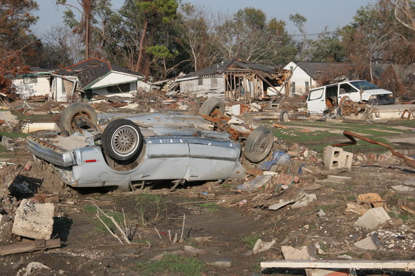
Vehicle & Homes, Lower Ninth Ward, New Orleans, Louisiana
The most severe loss of life and
property damage occurred in New Orleans, Louisiana, which flooded as the levee
system catastrophically failed, in many cases hours after the storm had moved
inland. The hurricane caused severe destruction across the entire Mississippi
coast and into Alabama, as far as 100 miles (160 km) from the storm's center.
Katrina was the eleventh tropical storm, fifth hurricane, third major hurricane,
and second Category 5 hurricane of the 2005 Atlantic season.
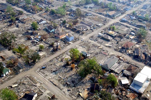
Lower Ninth Ward, New Orleans, Louisiana
Credit Jeff Schmaltz, MODIS Rapid Response Team, NASA/GSFC
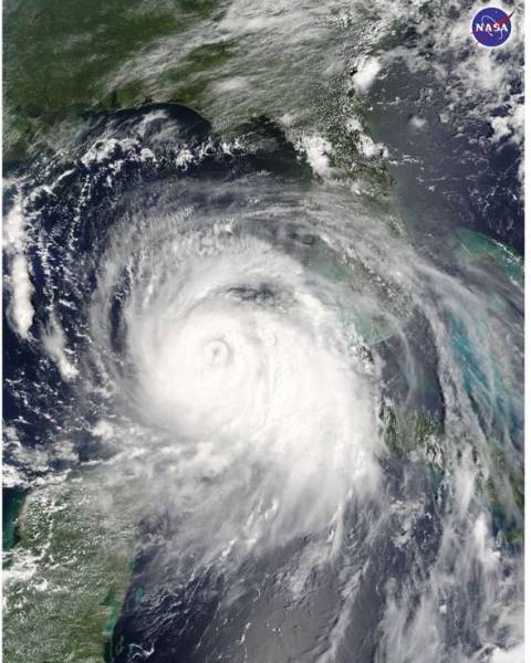
“Katrina is comparable in intensity to Hurricane Camille of 1969, only larger,”
warned the National Hurricane Center on Sunday, August 28, 2005. By this time,
Hurricane Katrina was set to become one of the most powerful storms to strike
the United States, with winds of 257 kilometers per hour (160 miles per hour)
and stronger gusts. The air pressure, another indicator of hurricane strength,
at the center of this Category 5 storm measured 902 millibars, the fourth lowest
air pressure on record for an Atlantic storm. The lower the air pressure, the
more powerful the storm.
Two hours after the National Hurricane Center issued their warning, the Moderate
Resolution Imaging Spectroradiometer (MODIS) captured this image from NASA’s
Terra satellite at 1:00 p.m. Eastern Daylight Savings Time. The massive storm
covers much of the Gulf of Mexico, spanning from the U.S. coast to the Yucatan
Peninsula.
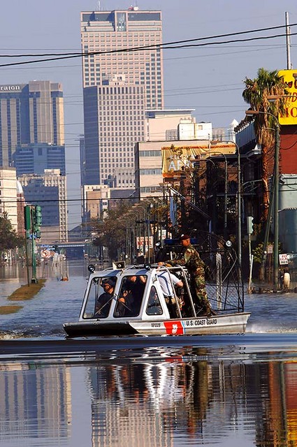
A U.S. Coast Guard air
boat navigates the flooded streets of New Orleans
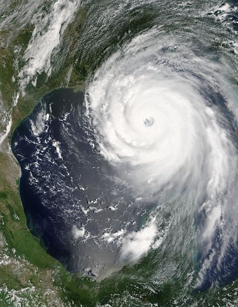
It formed over the Bahamas on
August 23, 2005, and crossed southern Florida as a moderate Category 1
hurricane, causing some deaths and flooding there, before strengthening rapidly
in the Gulf of Mexico and becoming one of the strongest hurricanes on record
while at sea. The storm weakened before making its second and third landfalls as
a Category 3 storm on the morning of August 29 in southeast Louisiana and at the
Louisiana/Mississippi state line, respectively.
The storm surge caused severe
damage along the Gulf Coast, devastating the Mississippi cities of Waveland, Bay
St. Louis, Pass Christian, Long Beach, Gulfport, Biloxi, Ocean Springs, and
Pascagoula. In Louisiana, the federal flood protection system in New Orleans
failed in more than 50 places. Nearly every levee in metro New Orleans breached
as Hurricane Katrina passed east of the city, subsequently flooding 80% of the
city and many areas of neighboring parishes for weeks.
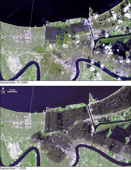
The floods that buried up to 80 percent of New Orleans had noticeably subsided
by September 15, 2005, when the top image was taken by the Landsat 7 satellite.
In the two and a half weeks that had passed since Hurricane Katrina flooded the
city, pumps had been working nonstop to return the water to Lake Pontchartrain.
As portable pumps were brought in to supplement the permanent pumps already hard
at work, as much as 380 cubic meters (380,000 liters or 23,190,000 cubic inches)
of water were being pumped out of New Orleans every second, according to the
U.S. Army Corps of Engineers.
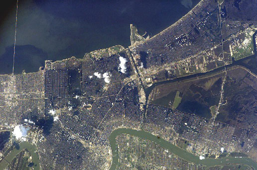
The extent of flooding in the greater New Orleans metropolitan area is clearly
visible in this image, acquired from the International Space Station on
September 8, 2005, of areas damaged by Hurricane Katrina. Flooded areas are dark
greenish brown, while dry areas to the west of the 17th Street Canal and along
the banks of the Mississippi River (lower half of image) are light brown to
gray. This cropped image (from the parent frame ISS011-E-12527) is oriented with
north to the top. Credit: NASA
At least 1,836 people lost their
lives in Hurricane Katrina and in the subsequent floods, making it the deadliest
U.S. hurricane since the 1928 Okeechobee Hurricane. The storm is estimated to
have been responsible for $81.2 billion (2005 U.S. dollars) in damage, making it
the costliest natural disaster in U.S. history. The catastrophic failure of the
flood protection in New Orleans prompted immediate review of the Army Corps of
Engineers since the agency has by congressional mandate sole responsibility for
design and construction of the flood protection. There was also widespread
criticism of the federal, state and local governments' reaction to the storm and
resulting in an investigation by the U.S. Congress and the resignation of
Federal Emergency Management Agency director Michael D. Brown. Conversely, the
National Hurricane Center and National Weather Service were widely commended for
accurate forecasts and abundant lead time.
Hurricane Katrina Track
CIMSS is a
Cooperative Institute formed through a Memorandum of Understanding between the
University of Wisconsin-Madison (UW-Madison), the National Oceanic and
Atmospheric Administration (NOAA) and the National Aeronautics and Space
Administration (NASA). CIMSS scientists conduct research using passive remote
sensing systems for meteorological and surface-based applications.