|
NASA
Satellites Detect Extensive Drought Impact on Amazon Forests
03.29.11
A new NASA-funded study has
revealed widespread reductions in the greenness of the forests in the vast
Amazon basin in South America caused by the record-breaking drought of
2010.
"The greenness levels of Amazonian vegetation -- a measure of its health
-- decreased dramatically over an area more than three and one-half times
the size of Texas and did not recover to normal levels, even after the
drought ended in late October 2010," said Liang Xu, the study's lead
author from Boston University.
The drought sensitivity of Amazon rainforests is a subject of intense
study. Scientists are concerned because computer models predict that in a
changing climate with warmer temperatures and altered rainfall patterns
the ensuing moisture stress could cause some of the rainforests to be
replaced by grasslands or woody savannas. This would cause the carbon
stored in the rotting wood to be released into the atmosphere, which could
accelerate global warming. The United Nations' Intergovernmental Panel on
Climate Change (IPCC) has warned that similar droughts could be more
frequent in the Amazon region in the future.
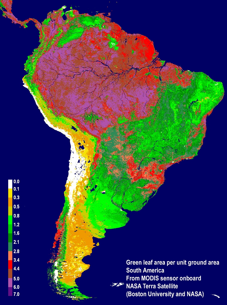
NASA satellite sensors,
such as MODIS, showed an average pattern of greenness of vegetation on
South America: Amazon forests which have very high leaf area are shown in
red and purple colors, the adjacent cerrado (savannas) which have lower
leaf area are shown in shades of green, and the coastal deserts are shown
in yellow colors. Image Credit: Boston University/NASA
The comprehensive study was prepared by an international team of
scientists using more than a decade's worth of satellite data from NASA's
Moderate Resolution Imaging Spectroradiometer (MODIS) and Tropical
Rainfall Measuring Mission (TRMM).
Analysis of these data produced detailed maps showing vegetation greenness
declines from the 2010 drought. The study has been accepted for
publication in Geophysical Research Letters, a journal of the American
Geophysical Union.
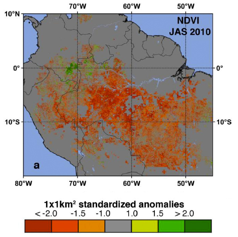
Red and orange identify
areas where satellite measurements indicated reduced Normalized Difference
Vegetation Index (first index of greenness) of the Amazon forest during
the 2010 drought. Image Credit: Boston University/NASA
The authors first developed maps of drought-affected areas using
thresholds of below-average rainfall as a guide. Next they identified
affected vegetation using two different greenness indices as surrogates
for green leaf area and physiological functioning. The maps show the 2010
drought reduced the greenness of approximately 965,000 square miles of
vegetation in the Amazon -- more than four times the area affected by the
last severe drought in 2005.
"The MODIS vegetation greenness data suggest a more widespread, severe and
long-lasting impact to Amazonian vegetation than what can be inferred
based solely on rainfall data," said Arindam Samanta, a co-lead author
from Atmospheric and Environmental Research Inc. in Lexington, Mass.
The severity of the 2010 drought was also seen in records of water levels
in rivers across the Amazon basin. Water levels started to fall in August
2010, reaching record low levels in late October. Water levels only began
to rise with the arrival of rains later that winter.
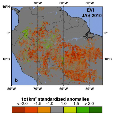
Red and orange identify
areas where satellite measurements indicated reduced Enhanced Vegetation
Index (second index of greenness) of the Amazon forest during the 2010
drought. Image Credit: Boston University/NASA
"Last year was the driest year on record based on 109 years of Rio Negro
water level data at the Manaus harbor. For comparison, the lowest level
during the so-called once-in-a-century drought in 2005, was only eighth
lowest," said Marcos Costa, coauthor from the Federal University in
Vicosa, Brazil.
As anecdotal reports of a severe drought began to appear in the news media
during the summer of 2010, the authors started near real-time processing
of massive amounts of satellite data. They used a new capability, the NASA
Earth Exchange (NEX), built for the NASA Advanced Supercomputer facility
at the agency's Ames Research Center in Moffett Field, Calif. NEX is a
collaborative supercomputing environment that brings together data, models
and computing resources.
With NEX, the study's authors quickly obtained a large-scale view of the
impact of the drought on the Amazon forests and were able to complete the
analysis by January 2011. Similar reports about the impact of the 2005
drought were published about two years after the fact.
"Timely monitoring of our planet's vegetation with satellites is critical,
and with NEX it can be done efficiently to deliver near-real time
information, as this study demonstrates," said study coauthor Ramakrishna
Nemani, a research scientist at Ames. An article about the NEX project
appears in this week's issue of Eos, the weekly newspaper of the American
Geophysical Union.
For more information about this study and the NEX project, visit
https://c3.ndc.nasa.gov/nex/projects/1209/
Credit: NASA
|


