An ocean (from Greek , "okeanos"
Oceanus) is a major body of saline water. The ocean covers 71 percent of the
Earth's surface and contains 97 percent of the planet's water, yet more than 95
percent of the underwater world remains unexplored. The ocean and lakes play an
integral role in many of the Earth's systems including climate and weather. The
ocean supports the life of nearly 50 percent of all species on Earth and helps
sustain that life providing 20 percent of the animal protein and five percent
of the total protein in the human diet.
Origins of Oceans National
Geographic
Today 71% of the Earth is covered with water, 29% by the 7 continents.
The percentage covered by water will increase as the Earth continues to
warm and polar ice caps melt.
Exploring Oceans: Overview National
Geographic
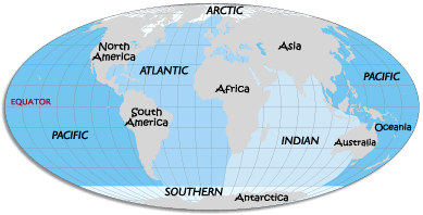
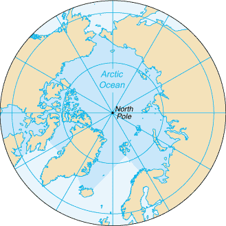
The great body of water embracing the continents of the Earth is also
known as the world ocean. Its major subdivisions are the Pacific, the
Atlantic, the Arctic, the Indian, and the Southern oceans.
More than one-half of the world's population lives within 60 miles (100
km) of the ocean.
Ocean
Surface Area
Of all
oceans
mi2
km2
Pacific
60,060,000
155,557,000
46.3%
Atlantic
29,637,000
76,762,000
22.8%
Indian
26,469,000
68,556,000
20.4%
Southern
7,848,000
20,327,000
6.1%
Arctic
5,427,000
14,056,000
4.2%
Deepest Oceans and Seas
Pacific Ocean (35,837 ft) (10,924 meters)
Atlantic Ocean (30,246 ft) (9,219 meters)
Indian Ocean (24,460 ft) (7,455 meters)
Caribbean Sea (22,788 ft) (6,946 meters)
Arctic Ocean (18,456 ft) (5,625 meters)
South China Sea (16,456 ft) (5,016 meters)
Bering Sea (15,659 ft) (4,773 meters)
Mediterranean Sea (15,197 ft) (4,632 meters)
Gulf of Mexico (12,425 ft) (3,787 meters)
Japan Sea (12,276 ft) (3,742 meters)
In ancient times, the term seven seas was used to describe all known large
bodies of water. These were: the Indian Ocean, the Red Sea, the Persian Gulf,
the Black Sea, the Sea of Azov, the Adriatic Sea, and the Caspian Sea. Today,
the term seven seas is used to refer to the Arctic, Antarctic, North Pacific,
South Pacific, North Atlantic, South Atlantic, and Indian Oceans.
Ninety
percent of all volcanic activity occurs in the oceans. In 1993,
scientists located the largest known concentration of active volcanoes
on the sea floor in the South Pacific. This area, the size of New York
state, hosts 1,133 volcanic cones and sea mounts. Two or three could
erupt at any moment.
The
highest tides in the world are at the Bay of Fundy, which separates
New Brunswick from Nova Scotia. At some times of the year the
difference between high and low tide is 53 feet 6 inches, the
equivalent of a three-story building.
Earth's
longest mountain range is the Mid-Ocean Ridge, which winds around the
globe from the Arctic Ocean to the Atlantic, skirting Africa, Asia and
Australia, and crossing the Pacific to the west coast of North
America. It is four times longer than the Andes, Rockies, and
Himalayas combined.
Canada has
the longest coastline of any country, at 56,453 miles or around 15
percent of the world's 372,384 miles of coastlines.
A slow
cascade of water beneath the Denmark Strait sinks 2.2 miles, more than
3.5 times farther than Venezuela's Angel Falls, the tallest waterfall
on land.
At the
deepest point in the ocean the pressure is more than 8 tons per square
inch, or the equivalent of one person trying to support 50 jumbo jets.
At 39
degrees Fahrenheit, the temperature of almost all of the deep ocean is
only a few degrees above freezing.
If mined,
all the gold suspended in the world's seawater would give each person
on Earth 9 pounds.
Although
Mount Everest, at 29,028 feet, is often called the tallest mountain on
Earth, Mauna Kea, an inactive volcano on the island of Hawaii, is
actually taller. Only 13,796 feet of Mauna Kea stands above sea level,
yet it is 33,465 feet tall if measured from the ocean floor to its
summit.
If the
ocean's total salt content were dried, it would cover the continents
to a depth of 5 feet.
Undersea
earthquakes and other disturbances cause tsunamis, or great waves. The
largest recorded tsunami measured 210 feet above sea level when it
reached Siberia's Kamchatka Peninsula in 1737.
The
Antarctic Ice Sheet is almost twice the size of the United States.
Layers of the Ocean
U.S. Weather Service Graphic
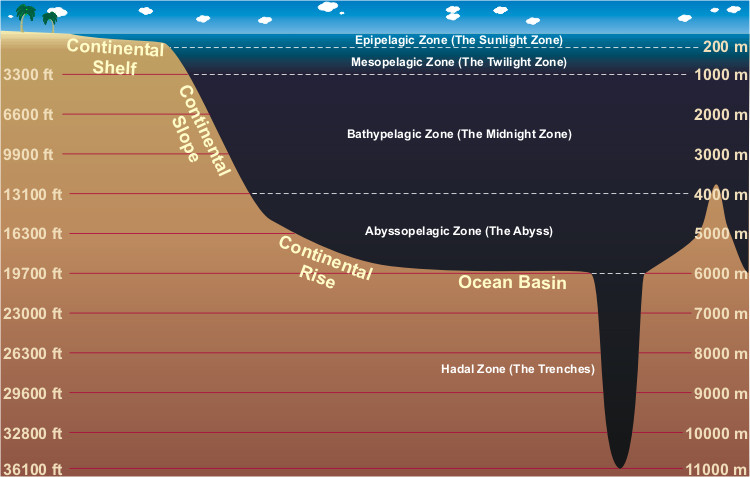
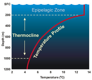
Epipelagic Zone
This surface layer is also called the sunlight zone
and extends from the surface to 660 feet (200 m). It is in this zone that
most of the visible light exists. With the light comes heating from sun.
This heating is responsible for wide change in temperature that occurs in
this zone, both in the latitude and each season. The sea surface
temperatures range from as high as 97°F (36°C) in the Persian Gulf to 28°F
(-2°C) near the north pole.
The sea surface temperature also "follows the sun". From the earth's
perspective, the sun's position in the sky moves higher each day from winter
to summer and lower each day from summer to winter. This change in the sun's
position from winter to summer means that more energy is reaching the ocean
and therefore warms the water.Interaction with the wind keeps this layer
mixed and thus allows the heating from the sun to be distributed vertically.
At the base of this mixing layer is the beginning of the thermocline. The
thermocline is a region where water temperature decreases rapidly with
increasing depth and transition layer between the mixed layer at the surface
and deeper water.
The depth and strength of the thermocline varies from season to season and
year to year. It is strongest in the tropics and decrease to non-existent in
the poler winter season.
Mesopelagic Zone
Below the
epipelagic zone is the mesopelagic zone, extending from 660 feet (200
meters) to 3,300 feet (1,000 meters). The mesopelagic zone is sometimes
referred to as the twilight zone or the midwater
zone as sunlight this deep is very faint. Temperature changes the greatest
in this zone as this is the zone with contains the thermocline.
Because of the lack of light, it is within this zone that bioluminescence
begins to appear on life. The eyes on the fishes are larger and generally
upward directed, most likely to see silhouettes of other animals (for food)
against the dim light.
Bathypelagic Zone
The depths from
3,300 - 13,100 feet (1,000-4,000 meters) comprise the bathypelagic zone. Due
to its constant darkness, this zone is also called the midnight
zone. The only light at this depth (and lower) comes from the
bioluminescence of the animals themselves.
The temperature in the bathypelagic zone, unlike that of the mesopelagic
zone, is constant. The temperature never fluctuates far from a chilling 39°F
(4°C). The pressure in the bathypelagic zone is extreme and at depths of
13,100 feet (4,000 meters), reaches over 5850 pounds per square inch! Yet,
sperm whales can dive down to this level in search of food.
Abyssopelagic Zone
The
Abyssopelagic Zone (or abyssal zone) extends from 13,100 feet (4,000 meters)
to 19,700 feet (6,000 meters). It is the pitch-black bottom layer of the
ocean. The name (abyss) comes from a Greek word meaning "no bottom" because
they thought the ocean was bottomless. Three-quarters of the area of the
deep-ocean floor lies in this zone. The water temperature is constantly near
freezing and only a few creatures can be found at these crushing depths. The
deepest a fish have ever been found was in the Puerto Rico Trench at 27,460
feet (8372 meters).
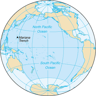
Hadalpelagic Zone
The deepest zone
of the ocean, the hadalpelagic zone extends from 19,700 feet (6,000 meters)
to the very bottom at 35,797 feet (10,911 meters) in the Mariana Trench off
the coast of Japan. The temperature is constant at just above freezing. The
weight of all the water over head in the Mariana Trench is over 8 tons per
square inch (the weight of 48 Boeing 747 jets).
Even at the very bottom life exists. In 2005, tiny single-celled organisms,
called foraminifera, a type of plankton, were discovered in the Challenger
Deep trench southwest of Guam in the Pacific Ocean.
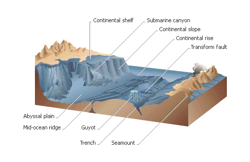
Ocean Floor
Features
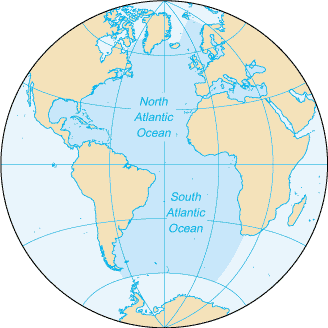
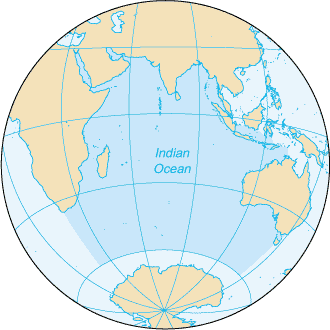
The three major ocean basins are the Atlantic, Indian, and Pacific Oceans .
These lie over oceanic crust and have an average depth of about 3800 meters.
The Atlantic Ocean is the youngest of the three and is dominated by a
central oceanic ridge and by abyssal plains of fine sediment. It has grown
during the past 200 million years at the expense of the Pacific Ocean.
The ocean province ranges from shallow coastal areas to the deepest ocean
environments. Many of the ocean features have been named and the particular
provinces described. The major features are discussed in the following
sections.
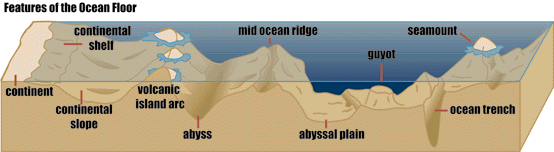
Ocean Ridges
The oceanic ridge system is the most pronounced tectonic feature on Earth.
The combined ridges are more than 60,000 km in length, with an area of 23%
of the earth's surface, almost equal to the total area of the continents.
These ridges extend as an almost continuous feature around the globe in the
form of spectacular mountain ranges of volcanic basalts. The ridges are
arched up and broken by numerous fault blocks to form linear hills and
valleys. A prominent rift valley marks the crest of the ridge throughout
most of its length. The general character of the ridge is a function of the
rate of plate separation. A slow rate of spreading produces a higher and
more rugged oceanic ridge than when the spreading rates are more rapid. Rift
valleys are also more prominent on ridges between slow moving plates.
The rift valley along the center of the rise is a zone of shallow
earthquakes. The system is not restricted to the oceans -- it emerges in
continental areas in Africa, California, and in Iceland . Numerous open
fissures have been observed and mapped in the rift valleys, which is
evidence that the crust is being pulled apart along the ridge. The eruption
of lava from these fractures parallels the rift valley and creates long
narrow ridges.
The oceanic ridge is cut by
faults normal to the ridge. Although these are strike-slip faults, vertical
displacement may form abrupt cliffs that can be traced for many kilometers .
Horizontal movement on these transform faults is on the order of 1-2 cm/yr
and the faults are marked by earthquake activity and vulcanism. The
magnitude of the system and its nature indicates that it is related to major
events and sources of energy in the Earth's interior.
Abyssal Hills and Abyssal
Plains
The abyssal hills have relatively low relief as they rise only 75 to 900
meters above the ocean floor. Abyssal hills were formed as oceanic ridge. As
the crust moves away from the spreading center, it cools and sinks to a
lower depth. The mountainous terrain of the oceanic ridge is maintained,
becoming low-lying abyssal hills at depths of more than 6,000 meters. The
hills are usually covered with a blanket of unconsolidated pelagic sediments
deposited with reasonable uniformity which gradually modifies and smoothes
the features but do not change the original volcanic ocean floor topography
that formed at the ridge.
A flat featureless surface known as an abyssal plain occurs when the hilly
sea floor has been covered by a thick fill of sediments, which were
deposited by turbidity currents. These river-like flows of a sediment water
mix are carried along the sea floor. They receive sediments from continental
margin submarine canyons which act as conduits for turbidity current
transport. The original irregular surface of a volcanic province remains
under the turbidite fill. These plains, which may slope less than 1:8000,
are found adjacent to land masses -- extending from the continental rise to
the abyssal hills. On prominences that rise above the plain, only sediments
settling in the water column (pelagic deep-sea sediments) occur. On the
surface of the plain, the pelagic sediments are interbedded with a
dominating sequence of sands, silts, and clays of terrigenous origin that
can be identified as turbidites by displaced benthic fauna and sediment
patterns characteristic of turbidites.
Deep Sea Trenches
A subduction zone, where two lithosphere plates converge and one slab of
plunges into the mantle, is expressed topographically by a trench. Deep-sea
trenches are long, narrow depressions in the ocean floor with depths greater
than 6000 meters and they can reach 11,000 meters in depth. Trenches are
found adjacent to land areas and associated with island arcs worldwide, but
they are more numerous in the Pacific Ocean. The trench is usually
asymmetric, with the steep side toward the adjacent land mass. Where a
trench occurs off continental margins, the turbidites from the slope are
trapped, forming a hadal plain on the floor of the trench.
Volcanic Islands, Seamounts, Guyots, Atolls
Volcanic cones reaching the ocean surface form volcanic islands . Subsidence
of a volcanic island with growth of coral keeping pace as it subsides will
result in the formation of an atoll . Drowning of ancient volcanic islands
by isostatic adjustment is shown by the coral atoll deposits drilled in the
Pacific. More than 1400 meters of shallow water carbonates -- deposited in
less than 100 meters water depth -- have been recovered from Bikini Atoll.
Guyots and seamounts are geomorphic forms developed from submarine
volcanoes. Seamounts and guyots are isolated, but they do lie in chains or
provinces of volcanic activity. They are found in all oceans, but more have
been recorded in the Pacific Ocean. The distribution that has been mapped
may represent a small percent of the total number since they are only noted
where crossed during bathymetric profiling. The seamount is a relatively
isolated elevation of the seafloor of more than 1000 meters height, with a
small rounded top -- a volcano that did not reach the sea surface. Guyots
are drowned volcanic islands that did not become coral atolls. They were
planed flat by wave action when at shallow depths, after which subsidence
occurred so that they are like seamounts but with a flattened top that lie
more than 200 meters below the surface. Although some coral rubble may be
found on guyots, they are abrasional platforms that have subsided as a
result of isostatic adjustment, with some contributing effect from sea level
change.
Ocean Odyssey - Ocean Topology NASA
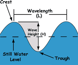
Waves
Everything from earthquakes
to ship wakes creates waves; however, the most common cause is wind. As wind
passes over the water's surface, friction forces it to ripple. The strength
of the wind, the distance the wind blows (fetch) and the length of the gust
(duration) determine how big the ripples will become. Waves are divided into
several parts. The crest is the highest point on a wave, while the trough,
or valley between two waves, is the lowest point.Wavelength is the
horizontal distance, either between the crests or troughs of two consecutive
waves. Wave height is a vertical distance between a wave's crest and the
next trough. Wave period measures the size of the wave in time. A wave
period can be measured by picking a stationary point and counting the
seconds it takes for two consecutive crests or troughs to pass it.
In deep water, a wave is a
forward motion of energy, not water. In fact, the water does not even move
forward with a wave. If we followed a single drop of water during a passing
wave, we would see it move in a vertical circle, returning to a point near
its original position at the wave's end. These vertical circles are more
obvious at the surface. As depth increases, their effects slowly decrease
until completely disappearing about half a wavelength below the surface.
Waves -
Surf
In deep waters, only
wavelength and wave period affect a waves speed. As the wave
approaches shallow water, or water that is half the wavelength or less
deep, the ocean floor begins to affect the wave's shape and speed.
Wave height increases, and the crests become more peaked. As the
steepness increases, the wave becomes unstable. The forward speed of
the crest becomes faster than the speed
of the wave, and the wave breaks.
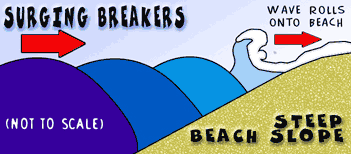
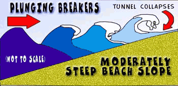
We can describe
breaking waves in three different ways: Surging
Breakers,Plunging Breakers and
Spilling Breakers. You see examples of these at the beach.
From "Ocean Talk" by Naval Meteorology and Oceanography Command.
Surging Breakers happen on beaches where the slope is very
steep. The wave does not actually break. Instead, it rolls onto the
steep beach. These kinds of breakers are known for their destructive
nature.
From "Ocean Talk" by Naval Meteorology and Oceanography Command.
Plunging Breakers happen on beaches where the slope is
moderately steep. This kind of wave normally curls over forming a
tunnel until the wave breaks. Expert surfers love this type of wave!
From "Ocean Talk" by Naval Meteorology and Oceanography Command.
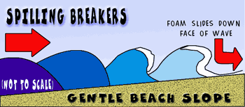
Spilling Breakers occur on beaches with gentle slopes. These
waves break far from the shore, and the surf gently rolls over the
front of the wave.
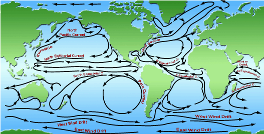
The ocean has four types of
motion:
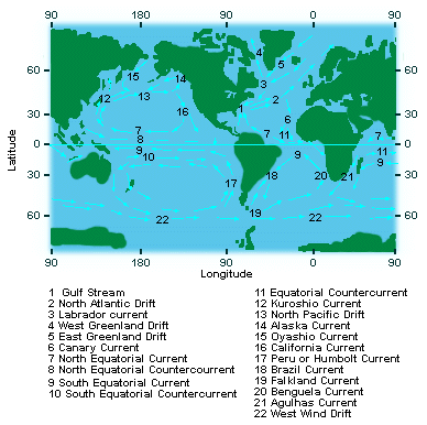
surface currents
The
ultimate reason for the world's surface ocean currents is the
sun. The heating of the earth by the sun has produced
semi-permanent pressure centers near the surface. When wind
blows over the ocean around these pressure centers, surface
waves are generated by transferring some of the wind's energy,
in the form of momentum, from the air to the water. This
constant push on the surface of the ocean is the force that
forms the surface currents.
Around the world, there are some similarities in the currents.
For example, along the west coasts of the continents, the
currents flow toward the equator in both hemispheres. These are
called cold currents as they bring cool water from the poler
regions into the topical regions. The cold current off the west
coast of the United States is called the California Current.
Likewise, the opposite is true as well. Along the east coasts of
the continents, the currents flow from the equator toward the
poles. There are called warm current as they bring the warm
tropical water north. The Gulf Stream, off the southeast United
States coast, is one of the strongest currents known anywhere in
the world, with water speeds up to 3 mph (5 kph).
These currents have a huge impact on the long-term weather a
location experiences. The overall climate of Norway and the
Bristish Isle is about 18°F (10°C) warmer in the winter than
other cites located at the same latitude due to the Gulf Stream.
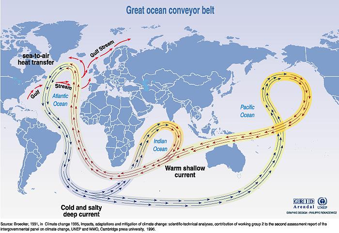
deep
circulation
While ocean currents are a shallow level circulations, there is
global circulation which extends to the depths of the sea called
the Great Ocean Conveyor. Also called the thermohaline
circulation, it is driven by differences in the density of the
sea water which is controlled by temperature (thermal) and
salinity (haline).
In
the northern Atlantic Ocean, as water flows north it cools
considerably increasing its density. As it cools to the freezing
point, sea ice forms with the "salts" extracted from the frozen
water making the water below more dense. The very salty water
sinks to the ocean floor.
It
is not static, but a slowly southward flowing current. The route
of the deep water flow is through the Atlantic Basin around
South Africa and into the Indian Ocean and on past Australia
into the Pacific Ocean Basin.
National Weather Service Graphic
If
the water is sinking in the North Atlantic Ocean then it must
rise somewhere else. This upwelling is relatively widepsread.
However, water samples taken around the world indicate that most
of the upwelling takes place in the North Pacific Ocean.
It
is estimated that once the water sinks in the North Atlantic
Ocean that it takes 1,000-1,200 years before that deep, salty
bottom water rises to the upper levels of the ocean.
tides
The
change in the water level with the daily tides from location to
location results from a many factors. The oceans and shorelines
have complex shapes and the depth, and configuration, of the sea
floor varies considerably.
As a
result, some locations only experience one high and low tide
each day, called a diurnal tide. Other locations experience two
high and low tides daily, called a semi-diurnal tide. Still,
other sites have mixed tides, where the difference in successive
high-water and low-water marks differ appreciably.
Another factor in the variation of tides is based on the orbit
of the moon around the earth and the earth around the sun. Both
orbits are not circles but ellipses. The distance between the
earth and moon can vary by up to 13,000 miles (31,000 km). Since
the tidal force increase with decreasing distance then tides
will be higher than normal when the moon is at its closest point
(called perogee) to the earth, approximately every 28 days.
Likewise, the earth's elliptical orbit also causes variations in
the sun's pull on the tides as we move from the closest point to
the farthest point (called apogee) over the course of a year.
And just to complicate things even more, the moon's orbit is
inclined 5° to the earth's rotation. So the north/south
orientations of the bulge also varies between the northern and
southern hemisphere over this same 28-day orbital period.
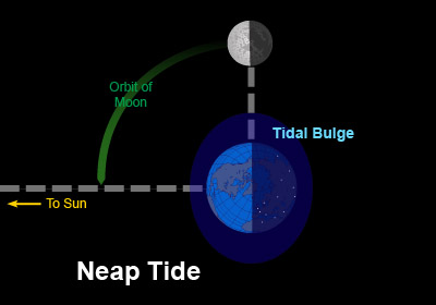
As
the moon completes one orbit around the earth (about every 28
days), there are two times in each orbit when the earth, moon
and and sun are inline with each other and two times when the
earth, moon and sun are at right angles.
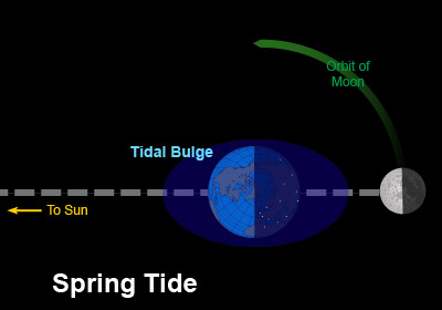
When
all three are inline (around full and new moons), the combined
effect of the moon's and sun's pull on the earth's water is at
its greatest resulting in the greatest ranges between high and
low tide. This called a "spring" tide (from the water springing
or rising up).
Seven days after either full or new moon, the earth, moon and
sun are at right angles to each other. At this time the pull of
the moon and the pull of the sun partially cancel each other
out. The resulting tide, called a "neap" tide, has the smallest
range between high and low tide
tsunamis
The
word is Japanese and means "harbor wave," because of the
devastating effects these waves have had on low-lying Japanese
coastal communities. The word tsunami (pronounced tsoo-nah'-mee)
is composed of the Japanese words "tsu" (which means harbor) and
"nami" (which means "wave").Tsunamis are often incorrectly
referred to as tidal waves, but a tsunami is actually a series
of waves that can travel at speeds averaging 450 (and up to 600)
miles per hour in the open ocean.
Tsunamis are a series of very long waves generated by any rapid,
large-scale disturbance of the sea. Most are generated by sea
floor displacements from large undersea earthquakes. Tsunamis
can cause great destruction and loss of life within minutes on
shores near their source, and some tsunamis can cause
destruction within hours across an entire ocean basin.
Credit: Office of Naval Research
(not to scale)
Most
tsunamis occur in the Pacific region but they are known to
happen in every ocean and sea. Although infrequent, tsunamis are
a significant natural hazard with great destructive potential
Different sources
provide energy for these different types of motion. Surface and deep currents
are powered by solar radiation. The energy source for the tides is gravitational
attraction of the Earth and Moon. The Earth's internal heat provides energy for
tsunamis.
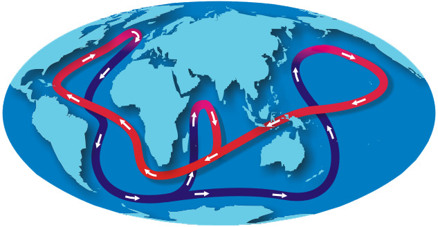
Currents and Climate introduces
viewers to oceanic thermohaline
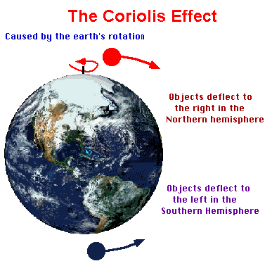
Wind and the rotation of the Earth are important in determining the flow
of surface currents and local areas of upwelling and downwelling, but
the true driving force of deep water movement is thermohaline
circulation.
Sometimes called the ocean conveyer belt, this mechanism is responsible
for bringing the oxygen that sustains life to the deepest reaches of the
sea, and in moving warmer waters from the tropics towards the poles.
Movement of this conveyer belt depends on sinking of cold water in
certain polar regions, thereby triggering the global thermohaline
circulation.
Oceanic Circulation Patterns Source: Office of Naval Research. Oceanography
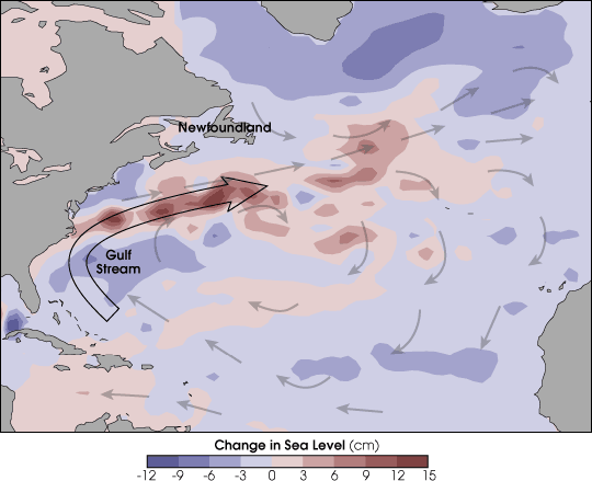
The Gulf Stream merges into the North Atlantic Current. This warm water
then flows up the Norwegian coast, with a westward branch warming
Greenland's tip, at 60°NIt keeps northern Europe about nine to eighteen
degrees warmer in the winter than comparable latitudes elsewhere.
NASA GSFC Satellite: TOPEX/Poseidon
Global warming could alter this. Because freshwater is less dense than
seawater, increased precipitation, melting of polar glaciers and ice
caps could block the system by reducing the amount of cold water that
sinks downwards.
As water travels through the water cycle, some water will become part of
The Global Conveyer Belt and can take up to 1,000 years to complete this
global circuit. It represents in a simple way how ocean currents carry
warm surface waters from the equator toward the poles and moderate
global climate. NASA Graphic
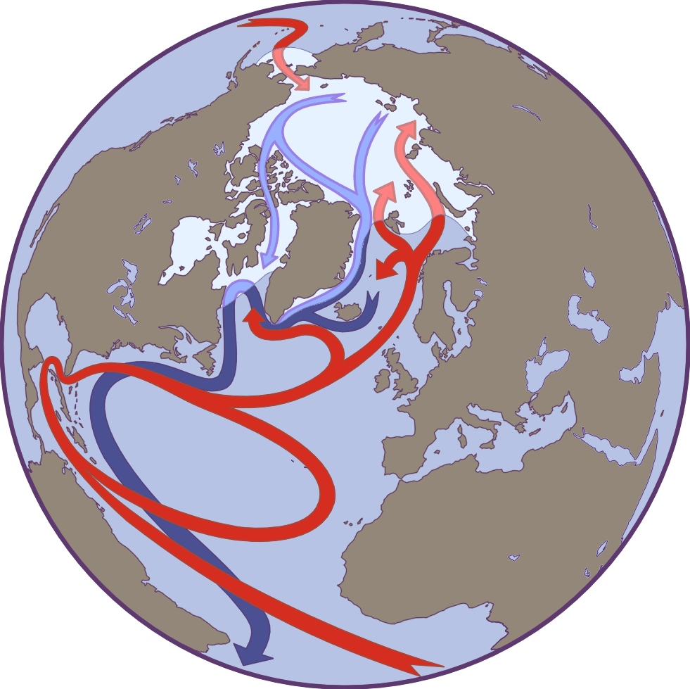
In the Atlantic, warm, high-salinity water flows northward in the Gulf
Stream along the east coast of North America. Some of this water
continues northeastward in the North Atlantic Current toward Iceland and
Norway.
THE ARCTIC HALOCLIINE—When sea ice forms, it releases salt into surface waters.
These waters become denser and sink to form the Arctic halocline—a layer of cold
water that acts as barrier between sea ice and deeper warmer water that could
melt the ice. (Illustration by Jayne Doucette, WHOI)
Off the coast of Greenland, a portion of the surface water cools,
becomes dense, and sinks. A further portion of surface water continues
into the Arctic Ocean before also cooling and sinking. Together these
sinking plumes off Greenland and in the Arctic form "deep water" that
plays an important role in global oceanic circulation.
Sea Water Salinity
Bigelow Laboratory for Ocean Sciences Graphic
The two most common elements in sea water, after oxygen and hydrogen,
are sodium and chloride. Sodium and chloride combine to form what we
know as table salt.
Sea water salinity is expressed as a ratio of salt (in grams) to liter
of water. In sea water there is typically close to 3.5 grams of
dissolved salts in each liter. It is written as 35‰ The normal range of
ocean salinity ranges between 3.3-3.7 grams per liter (33‰ - 37‰).
But as in weather, where there are ares of high and low pressure, there
are areas of high and low salinity. Of the five ocean basins, the
Atlantic Ocean is the saltiest. On average, there is a distinct decrease
of salinity near the equator and at both poles, although for different
reasons.
Near the equator, the tropics receive the most rain on a consistent
basis. As a result, the fresh water falling into the ocean helps
decrease the salinity of the surface water in that region. As one move
toward the poles, the region of rain decreases and with less rain and
more sunshine, evaporation increases.
Fresh water, in the form of water vapor, moves from the ocean to the
atmosphere through evaporation causing the higher salinity. Toward the
poles, fresh water from melting ice decreases the surface salinity once
again.
The saltiest locations in the ocean are the regions where evaporation is
highest or in large bodies of water where there is no outlet into the
ocean. The saltiest ocean water is in the Red Sea and in the Persian
Gulf region (around 40‰) due to very high evaporation and little fresh
water inflow.
Salinity—the amount of dissolved salt in the water—is critical to so
many aspects of the ocean, from circulation to climate to the global
water cycle. For the past year, NASA and Argentina’s Comisión Nacional
de Actividades Espaciales (CONAE) have been making comprehensive
observations of sea surface salinity from space. Launched on June 10,
2011, the Aquarius mission is slowly compiling a more complete picture
of the salty sea and how it varies.
The map above shows salinity near the ocean surface as measured by the
Aquarius instrument on the Satélite de Aplicaciones Científicas (SAC)-D
satellite. The data depicted shows average salinity from May 27 to June
2, 2012, in a range from 30 to 40 grams per kilogram, with 35 grams
being the average. Lower values are represented in purples and blues;
higher values are shown in shades of orange and red. Black areas occur
where no data was available, either due to the orbit of the satellite or
because the ocean was covered by ice, which Aquarius cannot see through.
Pressure
Even though we do not feel it, 14.7 pounds per square inch (psi), or 1kg
per square cm, of pressure are pushing down on our bodies as we rest at
sea level. Our body compensates for this weight by pushing out with the
same force.
Since water is
much heavier than air, this pressure increases as we venture into the
water. For every 33 feet down we travel, one more atmosphere (14.7 psi)
pushes down on us. For example, at 66 feet, the pressure equals 44.1 psi,
and at 99 feet, the pressure equals 58.8 psi.
Density
Temperature, salinity and pressure work together to determine water
density (weight of water divided by the amount of space it occupies).
Cold, salty water is much denser than warm, fresher water and will sink
below the less dense layer.
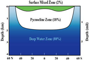
The ocean
waters can be divided into three layers, depending on their densities.
Less dense waters form a top layer called the surface mixed zone. The
temperature and salinity of this layer can change often because it is in
direct contact with the air. For example, water evaporation could cause an
increase in salinity, and a cold front could cause a drop in temperature.
The next layer is the pycnocline, or transition zone. The density here
does not change very much. This transition zone is a barrier between the
surface zone and a bottom layer, allowing little water movement between
the two zones.
The bottom
layer is the deep zone, where the water remains cold and dense. The polar
regions are the only places where deep waters are ever exposed to the
atmosphere because the pycnocline is not always present.
The
oceans vital role in the Earth's carbon cycle
Life in the ocean consumes and releases large quantities of carbon
dioxide. Across Earth's oceans, tiny marine plants called phytoplankton
use chlorophyll to capture sunlight during photosynthesis and use the
energy to produce sugars. Phytoplankton are the basis of the ocean food
web, and they play a significant role in Earth's climate, since they
draw down carbon dioxide, a greenhouse gas, at the same rate as land
plants. About half of the oxygen we breathe arises from photosynthesis
in the ocean.
Because of their role in the ocean's biological productivity and their
impact on climate, scientists want to know how much phytoplankton the
oceans contain, where they are located, how their distribution is
changing with time, and how much photosynthesis they perform. They
gather this information by using satellites to observe chlorophyll as an
indicator of the number, or biomass, of phytoplankton cells.
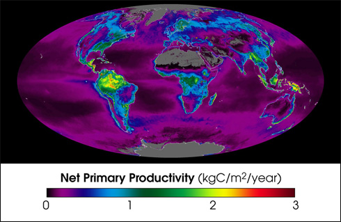
This false-color map represents the Earth's carbon "metabolism"-the rate
at which plants absorbed carbon out of the atmosphere. The map shows the
global, annual average of the net productivity of vegetation on land and
in the ocean during 2002. The yellow and red areas show the highest
rates, ranging from 2 to 3 kilograms of carbon taken in per square meter
per year. The green, blue, and purple shades show progressively lower
productivity. Credit: NASA Goddard Space Flight Center
Probably the most important and predominant pigment in the ocean is
chlorophyll-a contained in microscopic marine plants known as
phytoplankton. Chlorophyll-a absorbs blue and red light and reflects
green light. If the ratio of blue to green is low for an area of the
ocean surface, then there is more phytoplankton present. This
relationship works over a very wide range of concentrations, from less
than 0.01 ton early 50 milligrams of chlorophyll per cubic meter of
seawater.
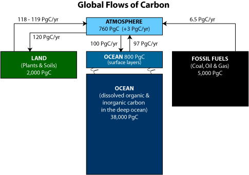
The ocean plays a
vital dominant role in the Earth's carbon cycle. The total amount of carbon in
the ocean is about 50 times greater than the amount in the atmosphere, and is
exchanged with the atmosphere on a time-scale of several hundred years. At least
1/2 of the oxygen we breathe comes from the photosynthesis of marine plants.
Currently, 48% of the carbon emitted to the atmosphere by fossil fuel burning is
sequestered into the ocean. But the future fate of this important carbon sink is
quite uncertain because of potential climate change impacts on ocean
circulation, biogeochemical cycling, and ecosystem dynamics.
Carbon atoms are
constantly being cycled through the earth's ocean by a number of physical and
biological processes. The flux of carbon dioxide between the atmosphere and the
ocean is a function of surface mixing (related to wind speed) and the difference
the concentration of carbon dioxide in the air and water The concentration in
the ocean depends on the atmosphere and ocean carbon dioxide partial pressure
which, in turn, is a function of temperature, alkalinity (which is closely
related to salinity), photosynthesis, and respiration. Carbon is also
sequestered for long periods of time in carbon reservoirs (sinks) such as deep
ocean and ocean sediment.
Prior to the
Industrial Revolution, the annual uptake and release of carbon dioxide by the
land and the ocean had been on average just about balanced. In more recent
history, atmospheric concentrations have increased by 80 ppm (parts per million)
over the past 150 years. However, only about half of the carbon released through
fossil fuel combustion in this time has remained in the atmosphere, the rest
being sequestered the ocean.
Watching Our Oceans JPL Video
The Ocean's Role
in Weather and Climate
The ocean is a
significant influence on Earth's weather and climate. The ocean covers 71% of
the global surface. This great reservoir continuously exchanges heat, moisture,
and carbon with the atmosphere, driving our weather patterns and influencing the
slow, subtle changes in our climate. The oceans influence climate by absorbing
solar radiation and releasing heat needed to drive the atmospheric circulation,
by releasing aerosols that influence cloud cover, by emitting most of the water
that falls on land as rain, by absorbing carbon dioxide from the atmosphere and
storing it for years to millions of years. The oceans absorb much of the solar
energy that reaches earth, and thanks to the high heat capacity of water, the
oceans can slowly release heat over many months or years. The oceans store more
heat in the uppermost 3 meters (10 feet) than the entire atmosphere.
The oceans and the
atmosphere form a closely linked "dynamic duo." Energy from the sun, plant
distributions, and greenhouse gasses in the atmosphere can affect temperature
and circulation patterns of this ocean-atmospheric duo.
The sun is Earth's
main source of energy. Solar energy is absorbed by both oceans and continents.
Because the oceans cover over 71% of Earth's surface and are darker than the
continents--they absorb more of the sun's energy. Oceans not only absorb
lots of energy from the sun--they can also store lots of solar energy in the
form of heat. And they can do this with very little change in temperature.
Sunlight warms the
surface of the ocean in the tropics. Wind-driven surface currents carry the heat
toward the poles. In the North Atlantic, the warm currents from the tropics feed
the North Atlantic Current shown in red in the figure. As the current flows
northward toward Norway and Greenland, it loses heat to the atmosphere and cools
down. In winter the water near Norway and Greenland gets so cold and dense it
sinks all the way to the bottom of the ocean. The cold bottom water feeds bottom
currents shown in blue and green. Eventually, mixing brings the bottom water
back to the surface in other parts of the ocean, sometime as far away as the
North Pacific. When the water gets to the surface, sunlight warms the water, and
the cycle starts over.
The alternating
influence of El Nino and La Nina are now well known These 3-5 year period
disruptions in weather patterns are caused by the movement of warm water in the
tropical Pacific, and are now predictable up to a year in advance because of a
special monitoring network of ocean buoys maintained there.
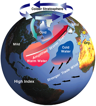
Illustration by
Fritz Heide & Jack Cook, WHOI
The North Atlantic
Oscillation (NAO). Its "high index" state is shown above, this corresponds to
particularly high atmospheric pressure over the Azores, an intense low over
Iceland. Ocean winds are stronger and winters milder in the eastern U.S. When
the NAO index is low, ocean winds are weaker and the U.S. winter more severe.
Changes in ocean temperature distributions are also observed.
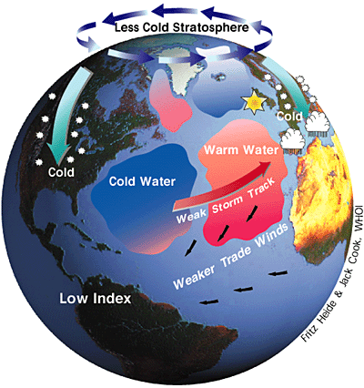
The North Atlantic
Oscillation (NAO). When the NAO index is low, shown above, ocean winds are
weaker and the U.S. winter more severe. Changes in ocean temperature
distributions are also observed. Its "high index" state corresponds to
particularly high atmospheric pressure over the Azores, an intense low over
Iceland. Ocean winds are stronger and winters milder in the eastern U.S.