|
||||||||||||
|
|
|
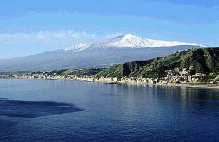
Mount Etna
Sicily's greatest natural attraction is also its highest mountain. To the ancient Greeks, Mount Etna was the realm of Vulcan, god of fire, and the home of the one-eyed monster known as the Cyclopses and where the giant Enceladus laid (eruptions being his breath and earthquakes his motion).
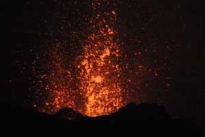
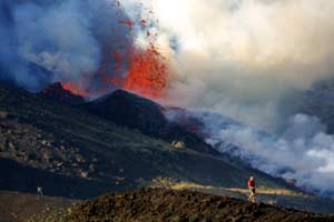
Eruption of Etna Volcano December 2006 video Thomas Reichart
At approximately 3350 meters, it is Europe's highest active volcano. The size of the summit changes with each eruption, and over the centuries a few lava flows have reached the coast. Over 1200 square meters of Etna's surface is covered with solidified lava. Etna offers skiing in the Winter months and breathtaking hikes in the woods during the Summer. There are also a number of smaller peaks on the slopes of Etna, and some interesting caverns. Since Etna is a strato volcano, with relatively cool lava temperatures and numerous openings (vents), nobody ever knows precisely where on its vast surface the next eruption will be.
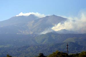
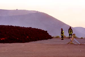
Etna October 2008
Foto di Davide Anastasi
There was a series of eruptions on Etna in January and June which showered local villages with ash but caused no damage or injuries. Some believe this may be a prelude to the volcano's first significant eruption in six years.
NASA Jacques Descloitres, MODIS Land Rapid Response Team Satellite: Terra Sensor: MODIS
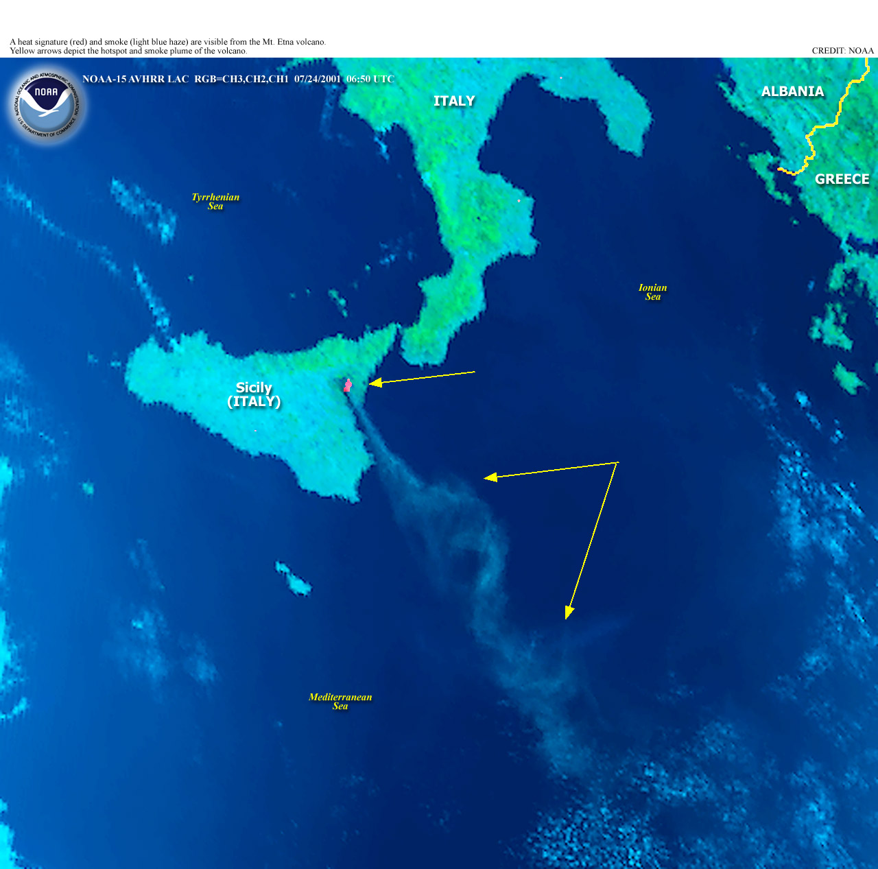
The Eruption of Mt. Etna NASA TERRA Located near the east coast of Italy's province of Sicily, Mount Etna is Europe's most active volcano and is one of the world's largest continental volcanoes, standing about 3,350 m (10,991 feet) tall. Mount Etna has a broad base (or shield) spanning roughly 60 by 40 km (36 by 24 miles) and reaching an altitude of about 2,900 m (9,500 feet). The remaining 400 m (1,200 feet) at its top is a stratovolcano made from several vents that have coalesced. Most of the surface of Mount Etna is covered by historic lava flows dating back to eruptions as old as 300,000 years. Scientists believe Mount Etna started as a submarine volcano that gradually grew to stand above sea level on layer upon layer of solidified lava. Among all the world's volcanoes, Mount Etna has the longest recorded history of eruptions, dating back to 1500 B.C. Since then, the volcano has erupted about 200 times and has been very active in recent decades. In particular, 2001 has been a busy year for Mount Etna, as there have been 16 eruptive episodes to date. The most recent began on July 13, 2001, accompanied by earthquakes and the opening of at least five vents on the volcano that released thick lava flows and vast columns of steam and smoke. Officials have been watching closely as the lava flowed to within 5 km (3 miles) of the town of Nicolosi (as of July 21).
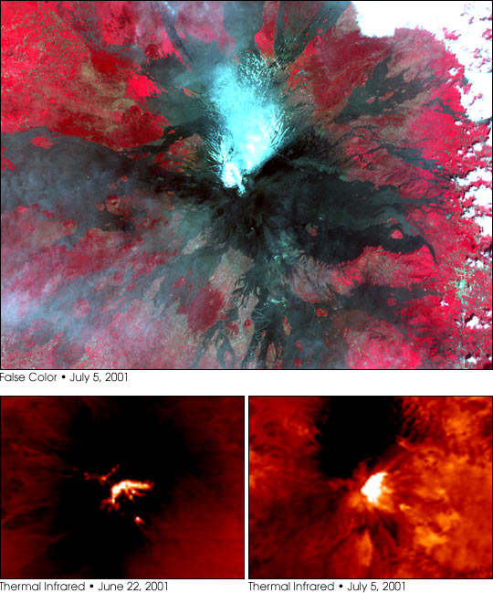
NASA/GSFC/MITI/ERSDAC/JAROS, and U.S./Japan ASTER Science Team Satellite: Terra Sensor: ASTER These perspective views of Mount Etna were acquired by the Advanced Spaceborne Thermal Emission and Reflection Radiometer (ASTER), flying aboard NASA's Terra satellite. The top image is a false-color image, acquired July 5, 2001, and produced using a combination of ASTER's visible and near-infrared channels. In that image, the blue-white pixels on the volcano's north slope are snow. The dark brown and black pixels radiating out away from Etna's caldera are exposed rock surfaces from previous lava flows. The deep red hues around the edges of the image indicate the presence of vegetation.The bottom pair of images were acquired by ASTER on June 22 (left) and July 5, 2001 (right). They were produced using ASTER's thermal infrared (heat) detector. The bright yellow-white pixels show the lava dome at the top of Mount Etna, as well as the locations of several vents, where heat is escaping.
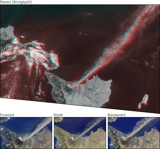
These Multi-angle Imaging SpectroRadiometer (MISR) images capture the July 22, 2001 explosion of the Mt. Etna volcano.At the bottom of this image set are true-color views from MISR's 70-degree forward-viewing camera, the vertical-viewing (nadir) camera, and the 70-degree backward-viewing camera. Each covers an area of 143 kilometers x 88 kilometers. The upper image is a stereo anaglyph created from the instrument's 70-degree and 46-degree forward views, and covers an area of 438 kilometers x 300 kilometers. To facilitate stereo viewing, the images are oriented with north at the left. Viewing the stereo image in 3-D requires red/blue glasses with the red filter placed over your left eye. Two plumes of differing compositions are seen to be emanating from Etna. The bright, brownish plume drifting southeast over the Ionian Sea is composed primarily of tiny frozen fragments of lava, known as ash. A fainter, bluish-white plume is also visible, especially near the summit, and is most apparent in the 70-degree forward view. It contains very fine droplets of dilute sulfuric acid. In addition to the particulate plumes visible in these images, the volcano also expels gases such as water vapor, sulfur dioxide, and carbon dioxide.
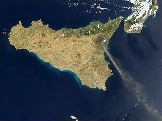
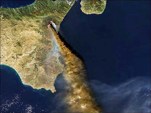
The eruption of Mt. Etna was overflown by the MODIS instrument on the NASA Aqua satellite on 28 October 2002. CIMSS scientists were interested in the composition of the plume which can be seen as the brown cloud spewing out of the volcano in the true color MODIS image. Activity on
Mount Etna In late June 2008, Sicily’s Mount Etna was releasing continuous plumes of ash and steam, according to the U.S. Air Force Weather Agency. The Advanced Spaceborne Thermal Emission and Reflection Radiometer (ASTER) on NASA’s Terra satellite caught the volcano’s activity in this picture taken on June 21, 2008. The volcano continued releasing plumes in early July. In this false-color image, made with a combination of visible and infrared light, vegetation appears bright red, bare ground appears charcoal, and the volcanic plume ranges in color from nearly white to pale blue. Signs of past eruptions appear in the rivulets of rock left over from old lava flows that spread out from the summit. Mount Etna is a stratovolcano composed of alternating layers of hardened lava, solidified ash, and rocks ejected by past eruptions. The plume shown in this image is mild compared to some of Etna’s past activity. Records of the volcano’s activity data back to 1500 BC. At 3,330 meters (10,925 feet) high, Etna towers over Catania, Sicily’s second-largest city. NASA image created by Jesse Allen, using data provided courtesy of NASA/GSFC/METI/ERSDAC/JAROS, and U.S./Japan ASTER Science Team. Caption by Michon Scott.
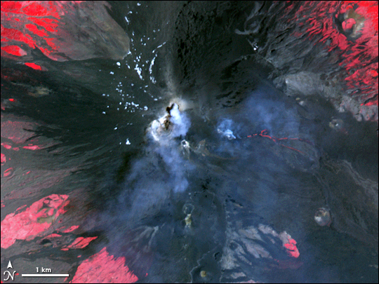
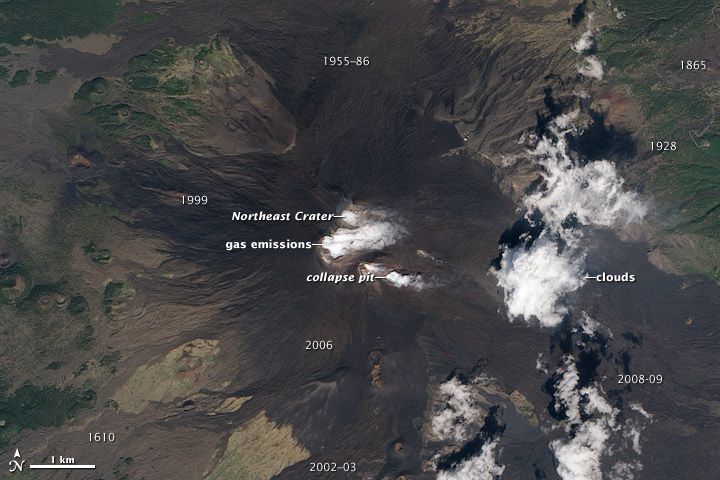
Even in the absence of an eruption, there are signs of activity at the summit of Mount Etna, Europe’s most active volcano. Water vapor and other volcanic gases overflow Etna’s summit craters, spilling out over the volcano’s upper slopes. A steam plume rises from a collapse pit that formed in late 2009, the newest volcanic feature on Etna. Dark lava flows from recent eruptions cover the peak, overlaying lighter, weathered flows from hundreds or thousands of years ago. (Numbers on the image indicate when a flow was erupted.) The oldest lavas are covered by green vegetation. Eruptive cones and fissures also dot the landscape. Although Etna is not currently erupting lava or ash, there is more activity than just gas emissions. Frequent explosions deep within the Northeast Crater, which may presage an upcoming eruption, are audible at the summit. These explosions were occurring sporadically every few minutes, as recorded by nearby seismometers. This natural-color satellite image was acquired by the Advanced Land Imager (ALI) aboard (EO-1) on September 26, 2010.NASA Earth Observatory image by Robert Simmon, using ALI data from the NASA EO-1 team. Caption by Robert Simmon.
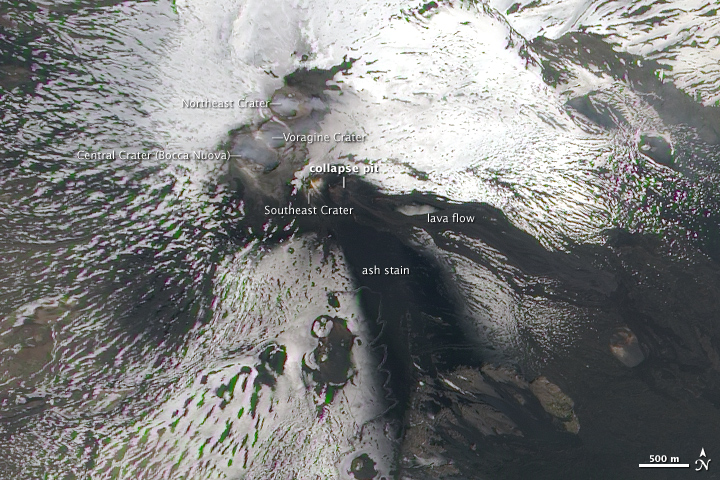
On April 10, Italy’s Mount Etna unleashed a sudden and violent eruption (called a paroxysmal episode,) for the third time in 2011. According to the Instituto Nazionale de Geofisica e Vulcanologie (INGV; National Institute of Geology and Volcanology), this episode included lava fountaining, a new lava flow from the collapse pit in the Southeast Crater, and ash and gas emissions. Wind carried the plume of ash to the southeast. Lava flowed down the side of the mountain, exploding at times as it struck snow on the side of the volcano. The episode was not particularly long-lived, however, and by evening much of the activity had subsided. The Advanced Land Imager (ALI) on NASA’s Earth Observing-1 (EO-1) satellite captured this natural-color image of Etna on April 13, 2011. By this time, activity was quite mild, but the volcano’s recent activity was evident. The ash plume settled on the snow, painting a dark curved arc from the collapse pit down the slopes. The three-kilometer lava flow and the associated pyroclastic flows run eastward from the pit and through the snowfields. Mount Etna has one of the world’s longest documented history of eruptive activity, with historical references to its eruptions going back 3,500 years. More or less continuous activity comes from the complex of summit craters. The Southeast Crater is a fairly recent addition to the summit, forming in 1978. Lava has flowed down the mountainside in almost every direction at some point in modern times.NASA Earth Observatory image created by Jesse Allen, using EO-1 ALI data provided courtesy of the NASA EO-1 team. Caption by Jesse Allen.
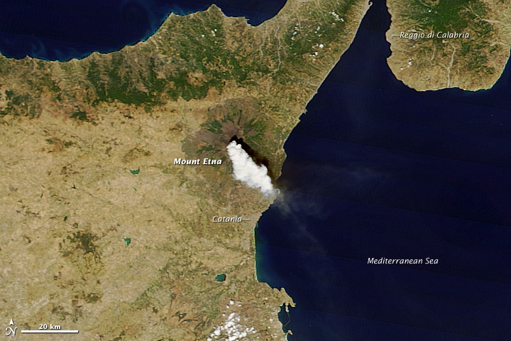
Throughout 2011, activity at Sicily’s Mount Etna has been characterized by paroxysms: short, violent bursts of activity. Each event has included volcanic tremors, ash emissions, and lava flows centered around the New Southeast Crater, just below the summit. On August 12, 2011, Etna had its tenth paroxysm of the year, captured in this natural-color satellite image. Etna spewed a thick white plume of gas and ash to the southeast, towards the nearby city of Catania. The ash cloud was produced by vigorous lava fountaining at the New Southeast Crater. The Toulouse Volcanic Ash Advisory Center estimated ash emissions reached an altitude of 14,000 feet (4,300 meters); 2,000 feet (600 meters) above the 10,925-foot (3,330-meter) summit. The image was captured at 11:40 a.m. local time by the Moderate Resolution Imaging Spectroradiometer (MODIS) aboard the Terra satellite.NASA image courtesy Jeff Schmaltz MODIS Rapid Response Team, NASA-GSFC. Caption by Robert Simmon.
|
||||||||||||||||||||||||||||||