|
||||||||||||
|
|
|
Supervolcano
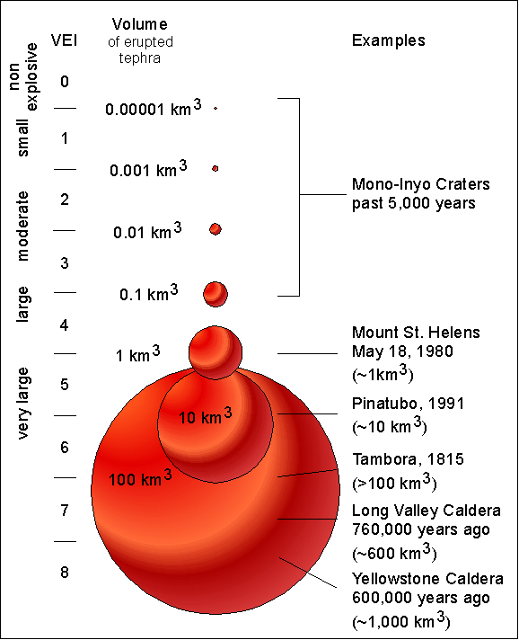
A supervolcano is a volcano that produces the largest and most voluminous kinds of eruption on Earth.The term "supervolcano" implies an eruption of magnitude 8 on the Volcano Explosivity Index, meaning that more than 1,000 cubic kilometers (240 cubic miles) of magma (partially molten rock) are erupted. The most recent such event on Earth occurred 74,000 years ago at the Toba Caldera in Sumatra, Indonesia. The power of such eruptions varies, but the volume of ejected material is enough to radically alter the landscape and severely affect global climate for years, with cataclysmic consequences for life. The term was originally coined by the producers of the BBC popular science program, Horizon, in 2000 to refer to these types of eruption. A supervolcano eruption packs the devastating force of a small asteroid colliding with the earth and occurs 10 times more often--making such an explosion one of the most dramatic natural catastrophes humanity should expect to undergo.
Supervolcanoes Around The World
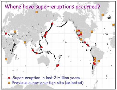
Around the world there are several other volcanic areas that can be considered "supervolcanoes"-
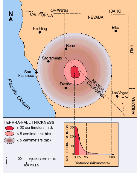
Long Valley Supervolcano
Long Valley, Calif., near the Nevada border
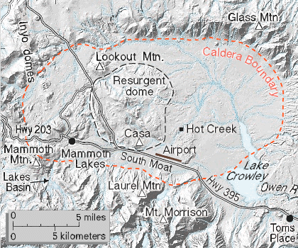
Volcano Number:120314-A Volcano Type:Caldera Volcano Status:Pleistocene-Fumarolic Last Known Eruption:Pleistocene Summit Elevation: 3390 m 11,122 feet Latitude:37.70°N37°42'0"N Longitude:118.87°W118°52'0"W The large 17 x 32 km Long Valley caldera east of the central Sierra Nevada Range formed as a result of the voluminous Bishop Tuff eruption about 760,000 years ago. Resurgent doming in the central part of the caldera occurred shortly afterwards, followed by rhyolitic eruptions from the caldera moat and the eruption of rhyodacite from outer ring fracture vents, ending about 50,000 years ago. During early resurgent doming the caldera was filled with a large lake that left strandlines on the caldera walls and the resurgent dome island; the lake eventually drained through the Owens River Gorge. The caldera remains thermally active, with many hot springs and fumaroles, and has had significant deformation, seismicity, and other unrest in recent years. The late-Pleistocene to Holocene Inyo Craters cut the NW topographic rim of the caldera, and along with Mammoth Mountain on the SW topographic rim, are west of the structural caldera and are chemically and tectonically distinct from the Long Valley magmatic system. Long Valley Caldera at a
Glance
Text and Maps from USGS
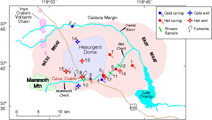
Map of Long Valley caldera showing locations of selected USGS hydrologic monitoring sites, the geothermal well field at Casa Diablo, and various geologic features referred to in the text. Numbered sites are described in the table below, which lists the maximum temperature in wells or the vent temperature in springs. The geologic features include Mammoth Mountain (the site of anomalous gas discharge that is killing trees), the Resurgent Dome (a highland region formed by repeated volcanic eruptions and magmatic uplift following the initial formation of the caldera 760,000 years ago), and the Inyo Craters Volcanic Chain consisting of numerous volcanic domes and phreatic craters that have erupted repeatedly over the past 10,000 years or so.
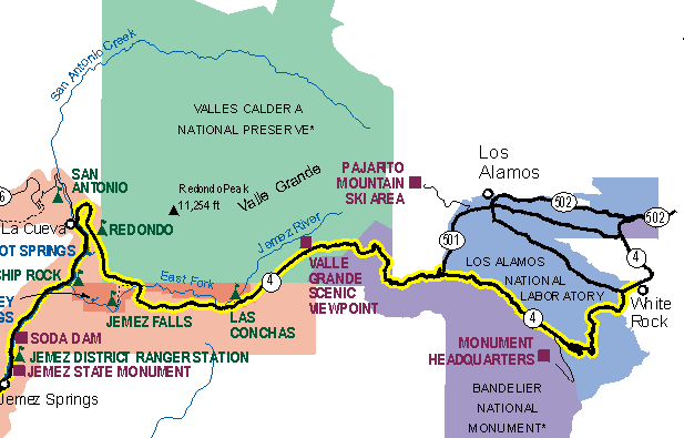
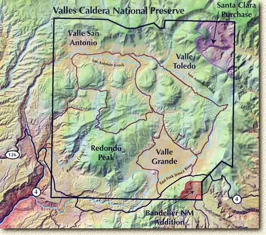
Valle Grande, N.M., near Los Alamos
Country:United
States
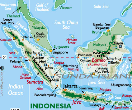
Lake Toba, Sumatra
Country: Indonesia Subregion Name: Sumatra (Indonesia) Volcano Number: 0601-09= Volcano Type: Caldera Volcano Status: Holocene Last Known Eruption: Unknown Summit Elevation: 2157 m 7,077 feet Latitude: 2.58°N 2°35'0"N Longitude: 98.83°E 98°50'0"E
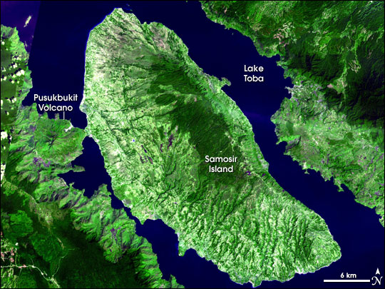
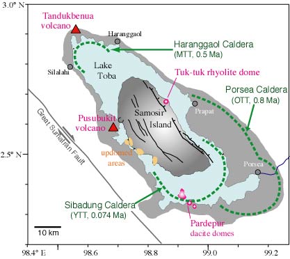
The 35 x 100 km Toba caldera, the Earth's largest Quaternary caldera, was formed during four major Pleistocene ignimbrite-producing eruptions beginning at 1.2 million years ago. The latest of these produced the Young Toba Tuff (YTT) about 74,000 years ago. The YTT represents the world's largest known Quaternary eruption, ejecting about 2500-3000 cu km (dense rock equivalent) of ignimbrite and airfall ash from vents at the NW and SE ends of present-day Lake Toba. Resurgent doming forming the massive Samosir Island and Uluan Peninsula structural blocks postdated eruption of the YTT. Additional post-YTT eruptions include emplacement of a series of lava domes, growth of the solfatarically active Pusukbukit volcano on the south margin of the caldera, and formation of Tandukbenua volcano at the NW-most rim of the caldera. Lack of vegetation suggests that this volcano may be only a few hundred years old (Chesner and Rose, 1991).
One of the largest known volcanic eruptions took place only 74,000 yrs ago, when over 2500 cubic kilometers of magma was ejected from Toba - a volcano-tectonic depression that is often referred to as Earth's largest Quaternary caldera. The caldera is 18 x 60 miles (30 by 100 km) and has a total relief of 5,100 feet (1700 m).Over what was probably a two-week span, thousands of cubic kilometers of debris spewed from Toba Caldera on northern Sumatra. Pyroclastic flows (fast-moving clouds of hot gas, rock fragments, and ash) buried at least 20,000 square kilometers around the caldera. As far away as India, ash from the Toba eruption lies in layers up to 6 meters (about 20 feet) thick; on Samosir Island, the ash layer is more than 600 meters (more than a quarter mile) thick.
Image courtesy of NASA/GSFC/MITI/ERSDAC/JAROS, and the U.S./Japan ASTER Science Team.
Following the eruption, the ground collapsed, leaving the modern caldera, which filled with water to make Lake Toba. Samosir Island is a resurgent volcanic dome, a mound of rock uplifted by pressure from un-erupted magma in the chamber beneath the volcano. The Pusukbukit Volcano on the western shore of the lake also formed after the catastrophic eruption.
credit: http://www.rpi.edu/~warkd/toba/toba_geology.html
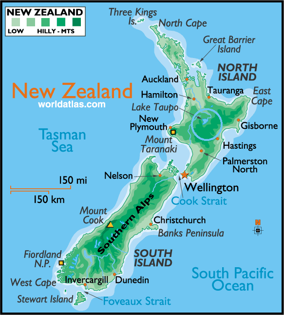
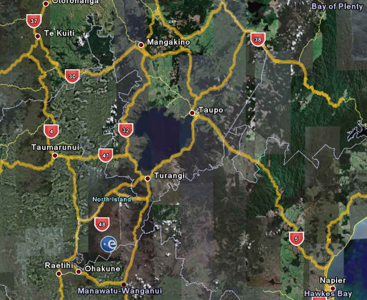
The caldera probably formed in stages. Large eruptions occurred 840,000, about 700,000, and 75,000 years ago. The eruption 75,000 years ago produced the Young Toba Tuff. The Young Toba Tuff was erupted from ring fractures that surround most or all of the present-day lake. Lake Taupo, New Zealand
credit: http://worldatlas.com
Country:New Zealand
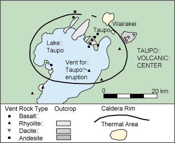
Taupo’s History
credit: http://volcano.und.nodak.edu/vwdocs/volc_images/australia/new_zealand/taupo.html
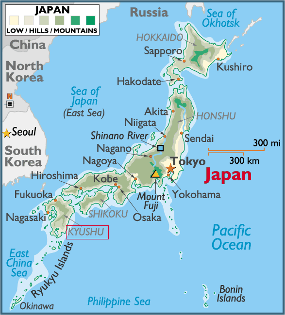
Credit: VOLCANIC HAZARDS AT TAUPO VOLCANIC CENTRE By Paul Froggatt Victoria Link Ltd & Research School of Earth Sciences, Victoria University of Wellington http://www.gns.cri.nz/what/earthact/volcanoes/nzvolcanoes/taupoprint.htm Aira, Japan Aira Caldera is a gigantic volcanic caldera in the south of the island of Kyushu, Japan. The caldera was created by a massive eruption, approximately 22,000 years ago. The major city of Kagoshima, Kagoshima and the 13,000 year old Sakurajima volcano lies within the caldera. Sakura-jima, one of Japan's most active volcanoes, is a post-caldera cone of the Aira caldera at the northern half of Kagoshima Bay. Eruption of voluminous pyroclastic flows accompanied formation of the 17 x 23 km wide Aira caldera at the eruption 22,000 years ago. Together with a large pumice fall, these amounted to more than 400 km3 of tephra.
Country:Japan
credit: http://worldatlas.com
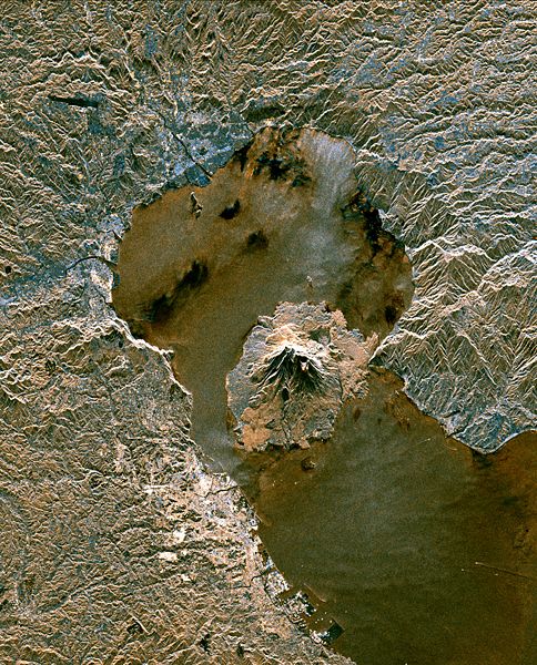
The active volcano Sakura-Jima on the island of Kyushu, Japan is shown in the center of this radar image. The volcano occupies the peninsula in the center of Kagoshima Bay, which was formed by the explosion and collapse of an ancient predecessor of today's volcano. The volcano has been in near continuous eruption since 1955. Its explosions of ash and gas are closely monitored by local authorities due to the proximity of the city of Kagoshima across a narrow strait from the volcano's center, shown below and to the left of the central peninsula in this image. City residents have grown accustomed to clearing ash deposits from sidewalks, cars and buildings following Sakura-jima's eruptions. The volcano is one of 15 identified by scientists as potentially hazardous to local populations, as part of the international "Decade Volcano" program. The image was acquired by the Spaceborne Imaging Radar-C/X-Band Synthetic Aperture Radar (SIR-C/X-SAR) onboard the space shuttle Endeavour on October 9, 1994. SIR-C/X-SAR, a joint mission of the German, Italian and the United States space agencies, is part of NASA's Mission to Planet Earth. The image is centered at 31.6 degrees North latitude and 130.6 degrees East longitude. North is toward the upper left. The area shown measures 37.5 kilometers by 46.5 kilometers (23.3 miles by 28.8 miles). The colors in the image are assigned to different frequencies and polarizations of the radar as follows: red is L-band vertically transmitted, vertically received; green is the average of L-band vertically transmitted, vertically received and C-band vertically transmitted, vertically received; blue is C-band vertically transmitted, vertically received. Credit:NASA/JPL-Caltech About 22,000 years ago a series of large-scale pyroclastic eruptions produced the Aira caldera (20 km×20 km wide at the northern end of Kagoshima Bay in southern Kyushu. It started with a Plinian pumice erution (Osumi pumice fall, 98 km3) followed by oxidized, fine-grained Tsumaya pyroclastic flow (13 km3), both erupted from a vent located at the present site of Sakuraijima volano, 8 km south of the caldera center. After a very short pause, violent explosive ejection of the basement rock fragments and pumiceous materials occurred at the central vent, gradually changing itself to a huge eruption column rapidly collapsing to form the Ito pyroclastic flow about 300 km3 in volume. The earliest phase produced up to 30-m-thick Kamewarizaka breccia developed along the caldera rim and charged with basement (lithic) fragments up to 2 m across. The breccia is a near-vent variety of the bottom concentration zone of lithics in the Ito deposit. Various textural features and monotonous petrologic character indicate that the main part of the Ito pyroclastic flow was emplaced by a simple, short-lived eruptive mechanism. The Aira-Tn ash, a fine-grained counterpart of the Ito pyroclastic flow, covered a wide area more than 1000 km from the vent. Evacuation of more than 110 km3 of rhyolitic magma produced a funnel-shaped collapse structure with the center of the magma chamber about 10 km deep. Like many other Japanese Quaternary calderas, the Aira caldera is considered to have formed not by a piston cylinder-type subsidence utilizing a ring fracture but by coring and high-angle slumping of the wall rocks into a funnel-shaped central vent. The outline of the caldera was strongly controlled by the faults bounding the volcano-tectonic graben forming Kagoshima Bay. Siberian Traps, Russia
http://palaeo.gly.bris.ac.uk/Palaeofiles/Permian/SiberianTraps.html
The Siberian Traps were the largest volcanic eruption in Earth history and they occurred right at the same time as the largest extinction event in Earth history.
About 252 million years ago, the largest mass extinction and the largest volcanic eruptions in Earth history occurred apparently synchronously: Worldwide ~90% of marine species and ~70% of terrestrial species went extinct In Siberia ~6,000,000 cubic kilometers of magma erupted, enough to cover the continental U.S. to almost a mile in depth.
http://www.le.ac.uk/gl/ads/SiberianTraps/Index.html
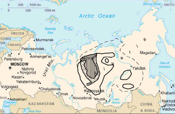
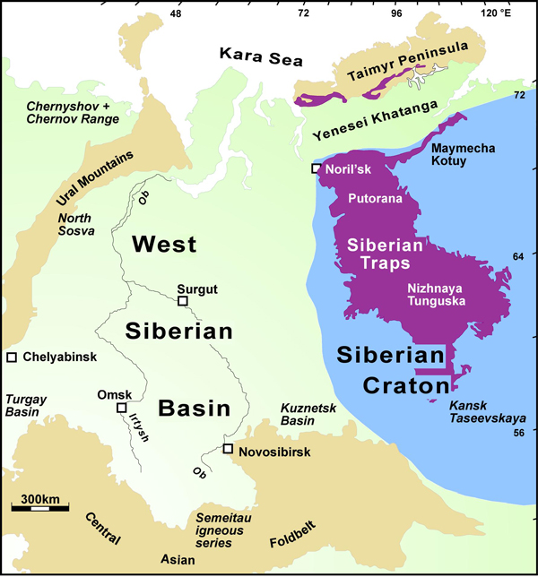
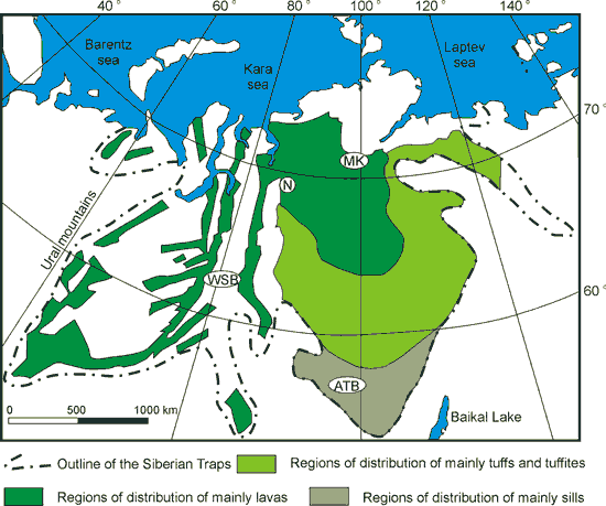
The Siberian Traps form a large igneous province in Siberia. The massive eruptive event spans the Permian-Triassic boundary, about 251 to 250 million years ago, and was essentially coincident with the Permian-Triassic extinction event in what was one of the largest known volcanic events of the last 500 million years of Earth's geological history. The term 'traps' is derived from the Swedish word for stairs (trappa, or sometimes trapp), referring to the step-like hills forming the landscape of the region. Vast volumes of basaltic lava paved over a large expanse of primeval Siberia in a flood basalt event.
Today the area covered is about 2 million km² and estimates of the original coverage are as high as 7 million km². The original volume of lava is estimated to range from 1 to 4 million km³. The area covered lies between 50 and 75 degrees north latitude and 60 to 120 degrees east longitude. The volcanism continued for a million years and spanned the Permian-Triassic boundary.
Source: United States Geological Survey, University of Utah, National Geographic,Thomas Reichert,The Geological Society of London |