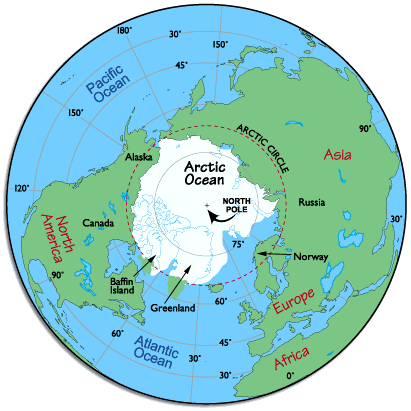
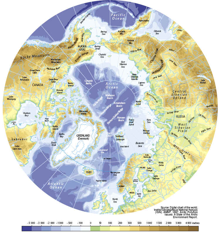
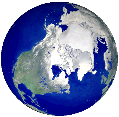
The Arctic consists of ocean
surrounded by continental land masses and islands. The central Arctic Ocean is
ice-covered year-round, and snow and ice are present on land for most of the
year.
The southern limit of the arctic
region is commonly placed at the Arctic Circle (latitude 66 degrees, 32 minutes
North). The Arctic Circle is an imaginary line that marks the latitude above
which the sun does not set on the day of the summer solstice (usually 21 June)
and does not rise on the the day of the winter solstice (usually 21 December).
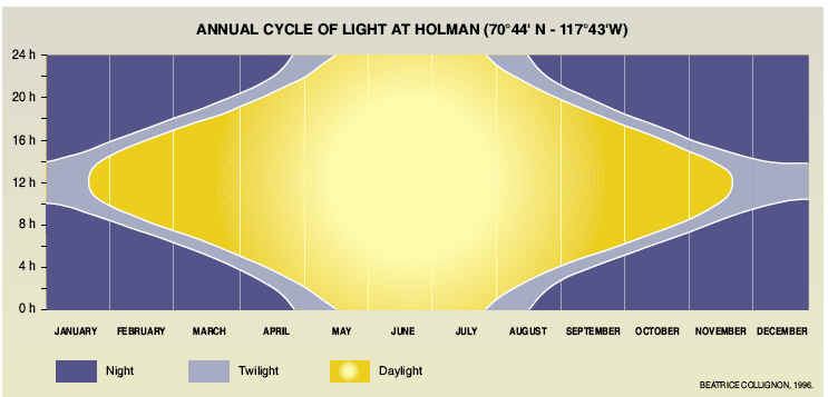
North of this latitude, periods of continuous daylight or night last up to six
months at the North Pole.
This region of the planet, north of the Arctic Circle, includes the Arctic
Ocean, Greenland, Baffin Island, other smaller northern islands, and the far
northern parts of Europe, Russia (Siberia), Alaska and Canada.
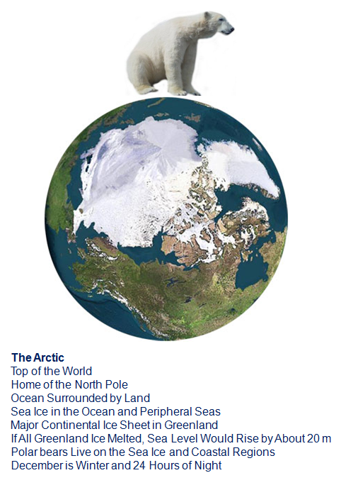
The Arctic is a vast, ice-covered ocean, surrounded by tree-less, frozen ground,
that teems with life, including organisms living in the ice, fish and marine
mammals, birds, land animals and human societies.
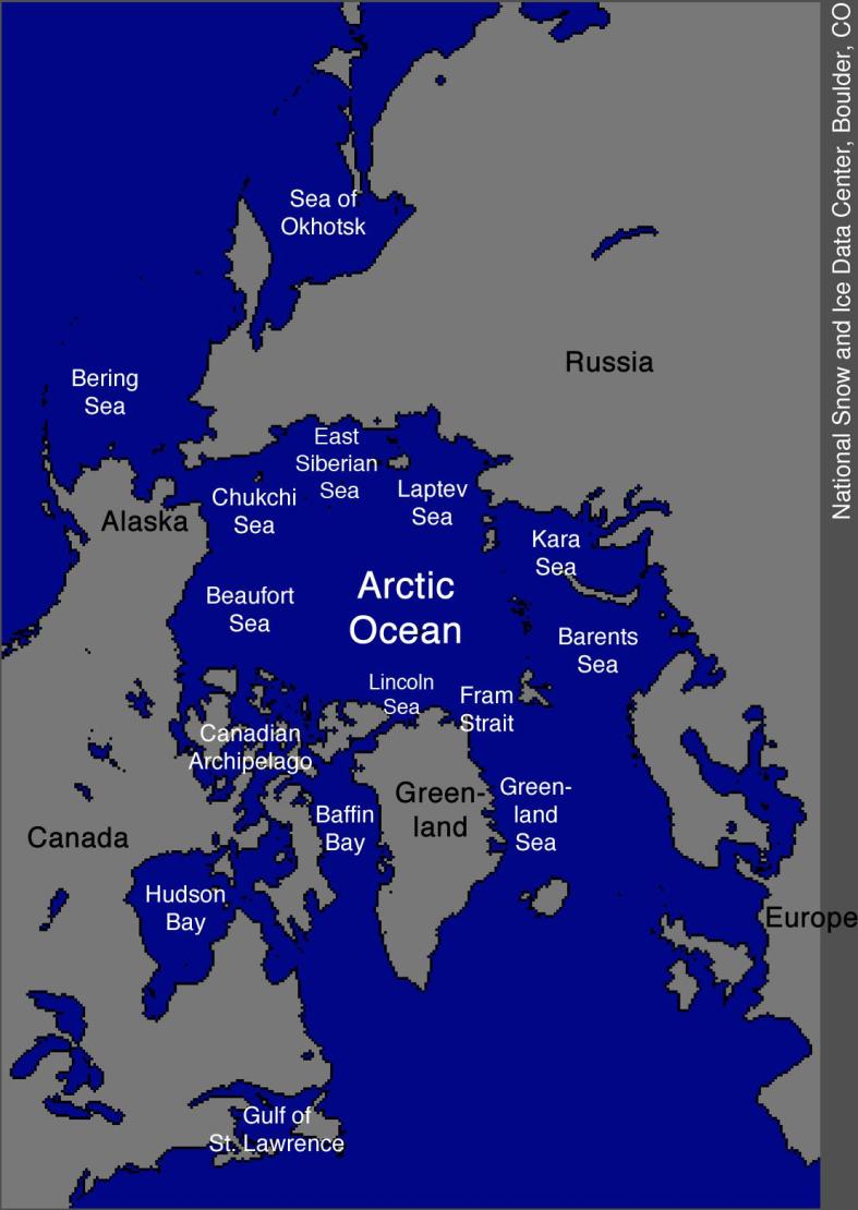
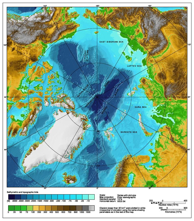
NSIDC Map
The Arctic consists of the Arctic Ocean, bordered by the northern parts of the
mainlands of North American and Eurasia, and their outlying islands. Some of
these islands are mountainous with interior icecaps, such as Greenland and the
northern half of Novaya Zemlaya. Others are low-lying and not glaciated, such as
Wrangel Island and the western islands of the Canadian Arctic.
Topography and Bathymetry
The Arctic Circle is an imaginary line located at 66º, 30'N latitude, and as a
guide defines the southernmost part of the Arctic. The climate within the Circle
is very cold and much of the area is always covered with ice.
In the mid winter months, the sun never rises and temperatures can easily reach
lows of - 50º F in the higher latitudes. In the summer months (further south),
24 hours of sunlight a day melts the seas and topsoil, and is the main cause of
icebergs breaking off from the frozen north and floating south, causing havoc in
the shipping lanes of the north Atlantic.
The total number of species as well as biological productivity is lower than in
more southern latitudes. Strong surface winds occur resulting in a severe
wind-chill, and abundant drifting snow in winter. Instead of tree growth there
is tundra vegetation that includes grasses, sedges, mosses, lichens, and
shrubs...all low-standing plants that exist on permafrost soils that are frozen
solid throughout most of the year.
In terms of marine life, because the waters of the Arctic are permanently
covered with a layer of drifting pack ice, sunlight never deeply penetrates the
surface waters to nourish and encourage biological growth. In addition, the
water is vertically stable, offering no upwelling of inorganic salts (like
phosphates, nitrates, and silicates,) without which a rich life in the upper
sunlit layers cannot exist. The result is that the true marine Arctic remains
cold and relatively lifeless. It is only near the land or in the Subarctic where
the pack-ice is seasonal and the waters are warmer and richer in nutrients, that
there is a proliferation of plant and animal life that encompasses the total
spectrum of the food chain from microscopic phytoplankton to walruses and
whales.
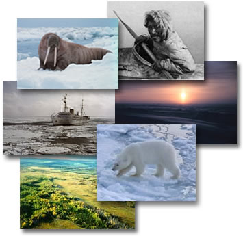
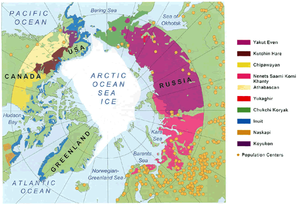
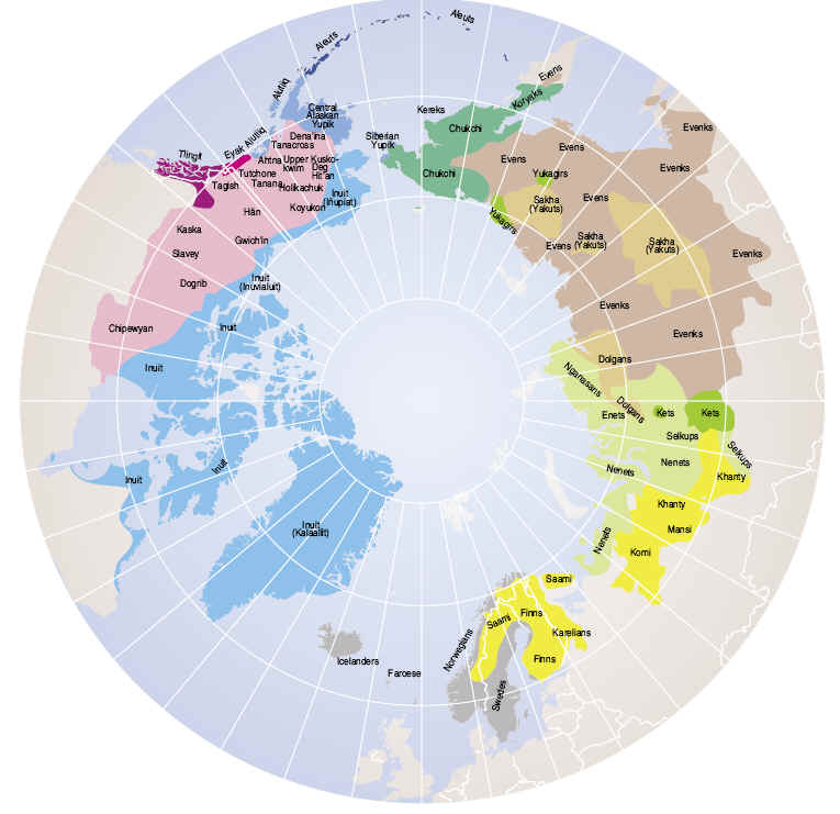
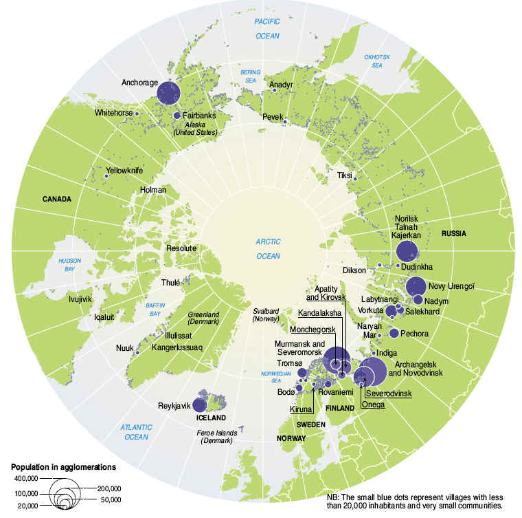
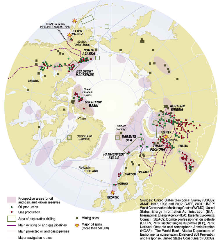
The primary residents of the Arctic include the Eskimos (Inuits), Lapps and
Russians with an overall population (of all peoples) exceeding two million. The
indigenous Eskimos have lived in the area for over 9,000 years, and many have
now given up much of their traditional hunting and fishing to work in the oil
fields and the varied support villages. Some contemporary occupants of the
Arctic and the areas they inhabit are shown on the map below.
The first explorers of the Arctic were Vikings. Norwegians visited the northern
regions in the 9th century, and Eric the Red (Icelander) established a
settlement in Greenland in 982.
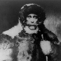
Robert E. Peary
The northernmost point on
the earth's surface is the geographic North Pole, also known as true north. It's
located at 90° North latitude and all lines of longitude converge at the pole.
The earth's axis connects the north and south poles, as its the line around
which the earth rotates. The North Pole is about 450 miles (725 km) north of
Greenland in the middle of the Arctic Ocean - the sea there has a depth of
13,410 feet (4087 meters). In 1909, after numerous attempts by regional
explorers, Robert E. Peary reached the North Pole.
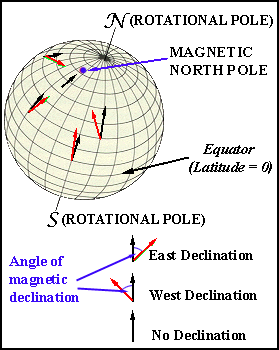
A magnetic compass does not point toward the true North Pole of the Earth.
Rather, it more closely points toward the North Magnetic Pole of the Earth. The
North Magnetic Pole is currently located in northern Canada. It wanders in an
elliptical path each day, and moves, on the average, more than forty meters
northward each day. Evidence indicates that the North Magnetic Pole has wandered
over much of the Earth's surface in the 4.5 billion years since the Earth
formed. The Earth's magnetic field is created by Earth's partially ionized outer
core, which rotates more rapidly than the Earth's surface.
NASA JPL, University of Alaska - Fairbanks Satellite: RADARSAT
Arctic Climate
The arctic climate is characterized by high spatial variability, and includes
both polar maritime (influenced by the ocean) and continental (influenced by
large land masses) climate subtypes. The main constant is that the climate in
all arctic areas is affected by the extreme solar radiation conditions of high
latitudes.
For example, the amount of solar radiation received in summer along the Siberian
arctic coast compares favorably, by virtue of the long period of daylight, with
that in lower middle latitudes. However, the low sun angle (elevation of the sun
above the horizon) means that even minor topographic features, such as low
hills, can cause major differences in climate at the local level by shading.
Even though the Arctic receives a large amount of solar energy in summer, the
high reflectivity (albedo) of snow and ice surfaces keeps absorption of solar
energy low. Therefore, the heat gained during the long summer days is small and
highly dependent on surface properties such as topography and albedo. For
instance, wet tundra and bare ground (with low albedo) absorb more solar
radiation than do high-albedo ice sheets. Similarly, wet snow absorbs more
radiation than dry snow. Solar radiation is small or absent in winter.
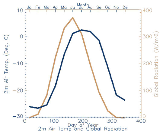
The annual cycle of global radiation (brown line) and surface air temperature
(blue line) at a grid cell location in the central Beaufort Sea. Values were
drawn from the Arctic Meteorology and Climate Atlas grided fields for global
radiation and two-meter air temperature.
Maritime climate
conditions prevail over the Arctic Ocean, coastal Alaska, Iceland, northern
Norway and adjoining parts of Russia. In these areas, winters are cold and
stormy. Summers are cloudy but mild with mean temperatures about 10 degrees
Celsius. Annual precipitation is generally between 60 cm and 125 cm, with a cool
season maximum (largely snowfall) and about six months of snow cover.
The interior,
continental climates have much more severe winters, although precipitation
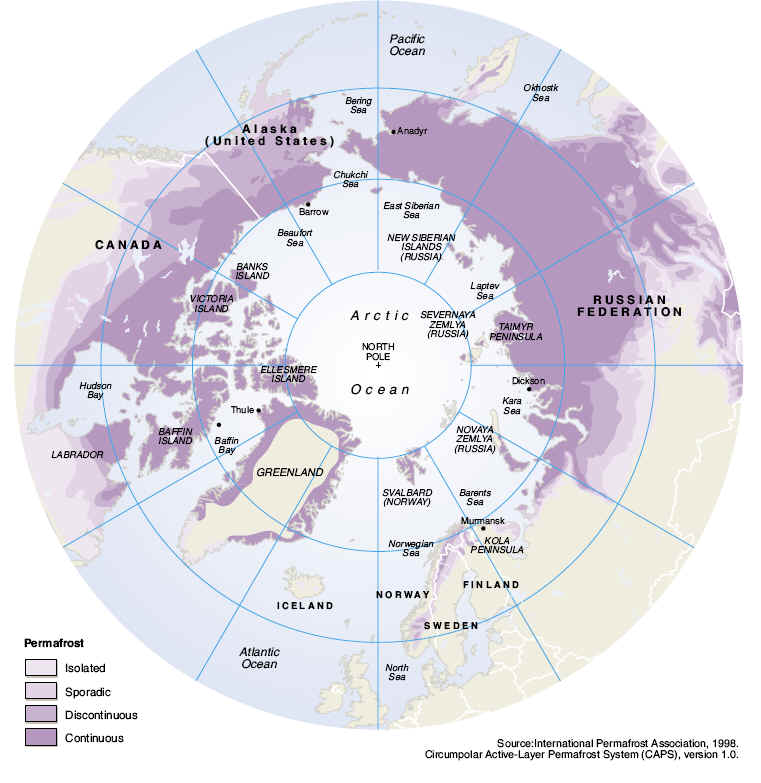
amounts are less. In these regions, permafrost (permanently frozen ground) is
wide-spread and often of great depth. In summer, only the top one to two meters
of ground thaw. Since the water cannot readily drain away, this "active layer"
often remains waterlogged. Although frost may occur in any month, long summer
days usually provide three months with mean temperatures above 10 degrees
Celsius, and at some stations in the continental interiors temperatures can
exceed 30 degrees Celsius.
In winter, arctic
weather is dominated by the frequent occurrence of inversions (when warm air
lies above a colder air layer near the surface). The inversion layer decouples
the surface wind from the stronger upper layer wind. For this reason, surface
wind speeds tend to be lower in winter than one might expect. In summer,
inversions are less frequent and weaker, and arctic weather patterns are
dominated by the movement of low pressure systems (cyclones) across Siberia and
into the Arctic Basin.
In many arctic and
subarctic regions, the weather is controlled by semipermanent low pressure
systems that are weakly developed in summer, but stronger in winter. The most
important of these low pressure systems are the Icelandic Low and the Aleutian
Low. In winter, eastern Eurasia is dominated by the semipermanent Siberian High.
High pressure is also prevalent over the Canadian Arctic Archipelago during the
cold season.
Arctic Mid-Ocean Ridge Expedition Graphic
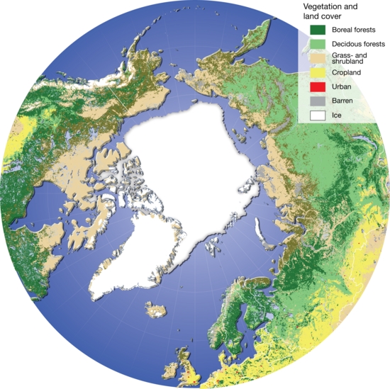
Vegetation of the circumpolar Arctic . The southern boundary of Arctic
vegetation is the treeline. This map gives a good impression of just how
closely tied the tundra biome is to the ocean; 61% of lowland tundra is
within 50 km of sea ice, 80% is within 100 km, and 100% is within 350 km.
I
Introduction
Arctic Ocean
Background:
The Arctic Ocean is the smallest of the world's five oceans (after the
Pacific Ocean, Atlantic Ocean, Indian Ocean, and the recently delimited
Southern Ocean). The Northwest Passage (US and Canada) and Northern Sea
Route (Norway and Russia) are two important seasonal waterways. A sparse
network of air, ocean, river, and land routes circumscribes the Arctic
Ocean.
Geography
Arctic Ocean
Location:
body of water between Europe, Asia, and North America, mostly north of the
Arctic Circle
Geographic coordinates:
90 00 N, 0 00 E
Map references:
Arctic Region
Area:
total:
14.056 million sq km note: includes Baffin Bay, Barents Sea, Beaufort Sea, Chukchi
Sea, East Siberian Sea, Greenland Sea, Hudson Bay, Hudson Strait, Kara
Sea, Laptev Sea, Northwest Passage, and other tributary water bodies
Area - comparative:
slightly less than 1.5 times the size of the US
Coastline:
45,389 km
Climate:
polar climate characterized by persistent cold and relatively narrow
annual temperature ranges; winters characterized by continuous darkness,
cold and stable weather conditions, and clear skies; summers characterized
by continuous daylight, damp and foggy weather, and weak cyclones with
rain or snow
Terrain:
central surface covered by a perennial drifting polar icepack that, on
average, is about 3 meters thick, although pressure ridges may be three
times that thickness; clockwise drift pattern in the Beaufort Gyral
Stream, but nearly straight-line movement from the New Siberian Islands
(Russia) to Denmark Strait (between Greenland and Iceland); the icepack is
surrounded by open seas during the summer, but more than doubles in size
during the winter and extends to the encircling landmasses; the ocean
floor is about 50% continental shelf (highest percentage of any ocean)
with the remainder a central basin interrupted by three submarine ridges
(Alpha Cordillera, Nansen Cordillera, and Lomonosov Ridge)
Elevation extremes:
lowest point: Fram Basin -4,665 m highest point: sea level 0 m
Natural resources:
sand and gravel aggregates, placer deposits, polymetallic nodules, oil and
gas fields, fish, marine mammals (seals and whales)
Natural hazards:
ice islands occasionally break away from northern Ellesmere Island;
icebergs calved from glaciers in western Greenland and extreme
northeastern Canada; permafrost in islands; virtually ice locked from
October to June; ships subject to superstructure icing from October to May
Environment - current
issues:
endangered marine species include walruses and whales; fragile ecosystem
slow to change and slow to recover from disruptions or damage; thinning
polar icepack
Geography - note:
major chokepoint is the southern Chukchi Sea (northern access to the
Pacific Ocean via the Bering Strait); strategic location between North
America and Russia; shortest marine link between the extremes of eastern
and western Russia; floating research stations operated by the US and
Russia; maximum snow cover in March or April about 20 to 50 centimeters
over the frozen ocean; snow cover lasts about 10 months
Economy
Arctic Ocean
Economy - overview:
Economic activity is limited to the exploitation of natural resources,
including petroleum, natural gas, fish, and seals.
Transportation
Arctic Ocean
Ports and terminals:
Churchill (Canada), Murmansk (Russia), Prudhoe Bay (US)
Transportation - note:
sparse network of air, ocean, river, and land routes; the Northwest
Passage (North America) and Northern Sea Route (Eurasia) are important
seasonal waterways
Transnational Issues
Arctic Ocean
Disputes - international:
the littoral states are engaged in various stages of demonstrating the
limits of their continental shelves beyond 200 nautical miles from their
declared baselines in accordance with Article 76, paragraph 8, of the
United Nations Convention on the Law of the Sea; record summer melting of
sea ice in the Arctic has restimulated interest in maritime shipping lanes
and sea floor exploration