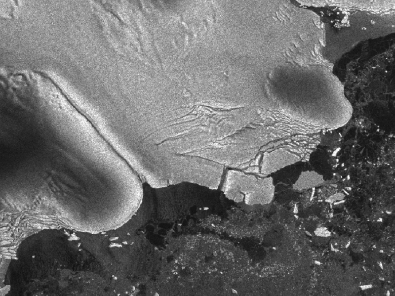
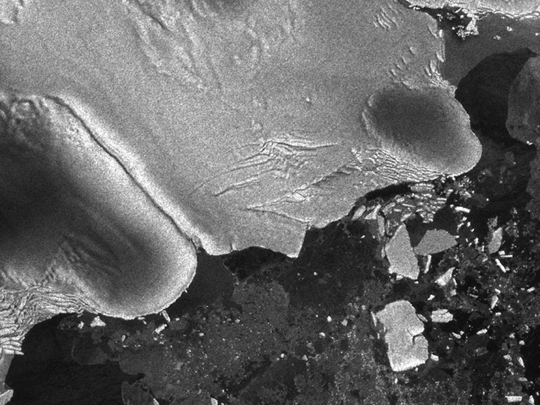
Before and after photos of the Sulzberger Ice Shelf
illustrate the calving event associated with the Japan earthquake and
resulting tsunami that occurred on March 11, 2011. The icebergs have
just begun to separate in the left image. Credit: European Space
Agency/Envisat
March 16
08.08.11 NASA Goddard
A NASA scientist and her
colleagues were able to observe for the first time the power of an
earthquake and tsunami to break off large icebergs a hemisphere away.
Kelly Brunt, a cryosphere specialist at Goddard Space Flight Center,
Greenbelt, Md., and colleagues were able to link the calving of icebergs
from the Sulzberger Ice Shelf in Antarctica following the Tohoku Tsunami,
which originated with an earthquake off the coast of Japan in March 2011.
The finding, detailed in a paper published online today in the Journal of
Glaciology, marks the first direct observation of such a connection
between tsunamis and icebergs.
The birth of an iceberg can come about in any number of ways. Often,
scientists will see the towering, frozen monoliths break into the polar
seas and work backwards to figure out the cause.
So when the Tohoku Tsunami was triggered in the Pacific Ocean on March 11
this spring, Brunt and colleagues immediately looked south. All the way
south. Using multiple satellite images, Brunt, Emile Okal at Northwestern
University and Douglas MacAyeal at University of Chicago were able to
observe new icebergs floating off to sea shortly after the sea swell of
the tsunami reached Antarctica.
To put the dynamics of this event in perspective: An earthquake off the
coast of Japan caused massive waves to explode out from its epicenter.
Swells of water swarmed toward an ice shelf in Antarctica, 8,000 miles
(13,600 km) away, and about 18 hours after the earthquake occurred, those
waves broke off several chunks of ice that together equaled about two
times the surface area of Manhattan. According to historical records, this
particular piece of ice hadn't budged in at least 46 years before the
tsunami came along.
And as all that was happening, scientists were able to watch the Antarctic
ice shelves in as close to real-time as satellite imagery allows, and
catch a glimpse of a new iceberg floating off into the Ross Sea.
"In the past
we've had calving events where we've looked for the source. It's a reverse
scenario – we see a calving and we go looking for a source," Brunt said.
"We knew right away this was one of the biggest events in recent history –
we knew there would be enough swell. And this time we had a source."
Scientists first speculated in the 1970s that repeated flexing of an ice
shelf – a floating extension of a glacier or ice sheet that sits on land –
by waves could cause icebergs to break off. Scientific papers in more
recent years have used models and tide gauge measurements in an attempt to
quantify the impact of sea swell on ice shelf fronts.
The swell was likely only about a foot high (30 cm) when it reached the
Sulzberger shelf. But the consistency of the waves created enough stress
to cause the calving. This particular stretch of floating ice shelf is
about 260 feet (80 meters) thick, from its exposed surface to its
submerged base.
When the earthquake happened, Okal immediately honed in on the vulnerable
faces of the Antarctic continent. Using knowledge of iceberg calving and
what a NOAA model showed of the tsunami's projected path across the
unobstructed Pacific and Southern oceans, Okal, Brunt and MacAyeal began
looking at what is called the Sulzberger Ice Shelf. The Sulzberger shelf
faces Sulzberger Bay and New Zealand.
Through a fortuitous break in heavy cloud cover, Brunt spotted what
appeared to be a new iceberg in MODerate Imaging Spectroradiometer (MODIS)
data.
"I didn't have strong expectations either way whether we'd be able to see
something," Brunt said. "The fastest imagery I could get to was from MODIS
Rapid Response, but it was pretty cloudy. So I was more pessimistic that
it would be too cloudy and we couldn't see anything. Then, there was
literally one image where the clouds cleared, and you could see a calving
event."
A closer look with synthetic aperture radar data from the European Space
Agency satellite, Envisat, which can penetrate clouds, found images of two
moderate-sized icebergs – with more, smaller bergs in their wake. The
largest iceberg was about four by six miles in surface area – itself about
equal to the surface area of one Manhattan. All the ice surface together
about equaled two Manhattans. After looking at historical satellite
imagery, the group determined the small outcropping of ice had been there
since at least 1965, when it was captured by USGS aerial photography.
The proof that seismic activity can cause Antarctic iceberg calving might
shed some light on our knowledge of past events, Okal said.
"In September 1868, Chilean naval officers reported an unseasonal presence
of large icebergs in the southernmost Pacific Ocean, and it was later
speculated that they may have calved during the great Arica earthquake and
tsunami a month earlier," Okal said. "We know now that this is a most
probable scenario."
MacAyeal said the event is more proof of the interconnectedness of Earth
systems.
"This is an example not only of the way in which events are connected
across great ranges of oceanic distance, but also how events in one kind
of Earth system, i.e., the plate tectonic system, can connect with another
kind of seemingly unrelated event: the calving of icebergs from
Antarctica's ice sheet," MacAyeal said.
In what could be one of the more lasting observations from this whole
event, the bay in front of the Sulzberger shelf was largely lacking sea
ice at the time of the tsunami. Sea ice is thought to help dampen swells
that might cause this kind of calving. At the time of the Sumatra tsunami
in 2004, the potentially vulnerable Antarctic fronts were buffered by a
lot of sea ice, Brunt said, and scientists observed no calving events that
they could tie to that tsunami.
"There are theories that sea ice can protect from calving. There was no
sea ice in this case," Brunt said. "It’s a big chunk of ice that calved
because of an earthquake 13,000 kilometers away. I think it's pretty
cool."