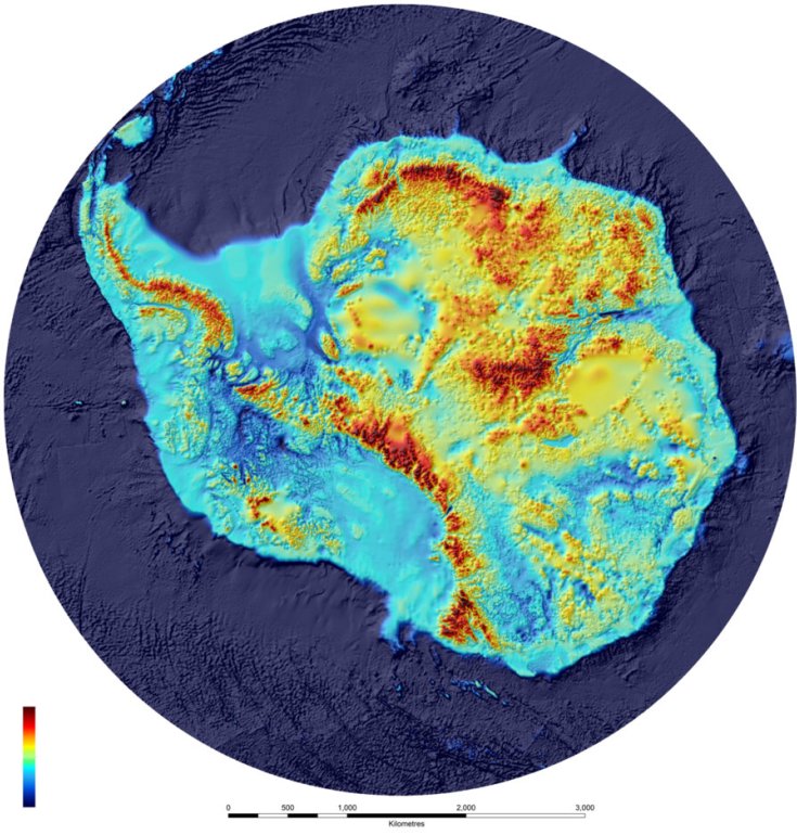
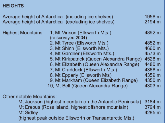
Scientists at British Antarctic
Survey (BAS) have produced the most detailed map of underneath Antarctica — its
rock bed.
BEDMAP is a close-up view of the
landscape beneath the Antarctic icesheet and incorporates decades of survey data
acquired by planes, satellites, ships and even researchers on dog-drawn sleds.
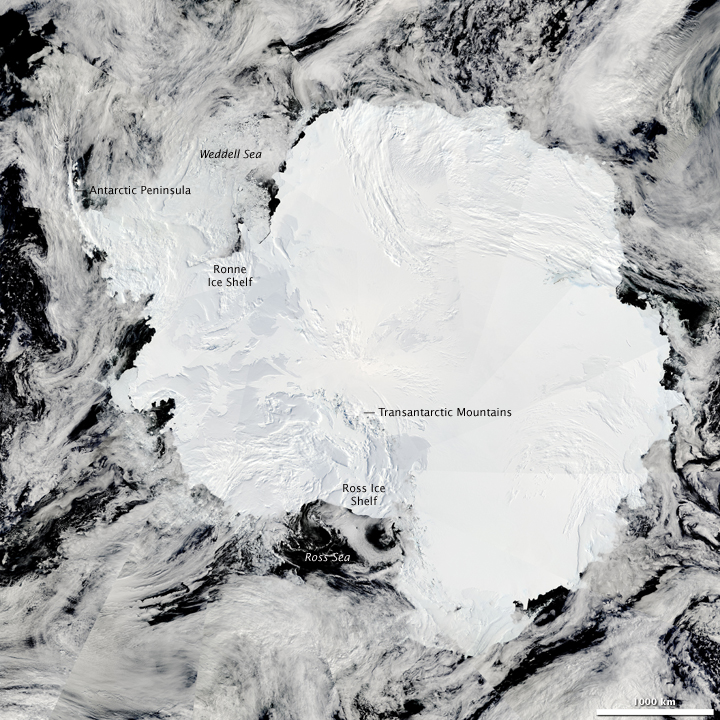
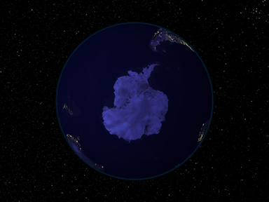
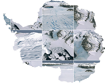
The Moderate Resolution Imaging Spectroradiometer (MODIS) on NASA’s Aqua
satellite captured this composite image on January 27, 2009
The elevation of the ice sheet shows the higher dome of the East Antarctic ice
sheet and the narrow connection between it and the West Antarctic ice sheet
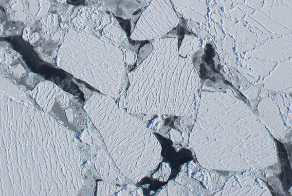
A view from a science flight over Antarctica: what sea ice looks like from
20,000 ft. straight up.
Credit:NASA Operation Ice bridge
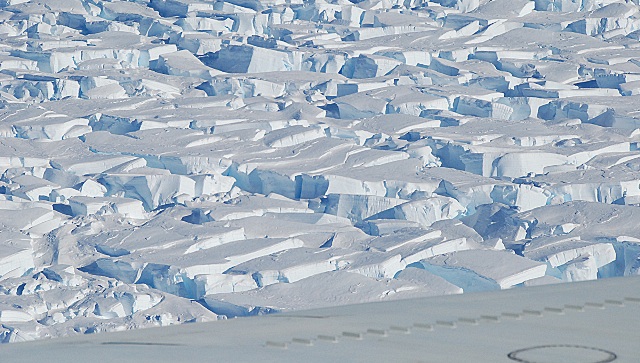
A heavily crevassed area of Pine Island Glacier. Shows you how very difficult it
would be to travel and work on the surface of this glacier. Data are best
collected from aircraft flying over the glacier or from space.
Credit:NASA Operation Ice bridge
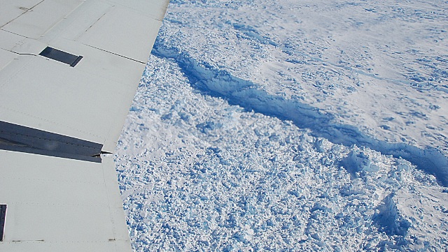
The calving front of Pine Island Glacier. This is the end of the glacier where
pieces of ice break apart from the floating glacier and become icebergs.
Credit:NASA Operation Ice bridge
Forest and woodland: 0%
Other:
100% (ice 98%, barren rock 2%)
Area:14 million sq km (280,000 sq km ice-free, 13.72 million sq km
ice-covered)
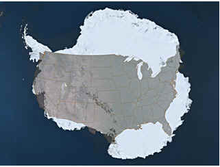
Comparing the sizes of Antarctica and the United States
Antarctica in 5 minutes Video
Terrain:about 98% thick continental ice sheet and 2% barren rock, with
average elevations between 2,000 and 4,000 meters; mountain ranges up to
nearly 5,000 meters; ice-free coastal areas include parts of southern
Victoria Land, Wilkes Land, the Antarctic Peninsula area, and parts of Ross
Island on McMurdo Sound; glaciers form ice shelves along about half of the
coastline, and floating ice shelves constitute 11% of the area of the
continent
Elevation extremes:lowest point: Bentley Subglacial Trench -2,555 m
highest point: Vinson Massif 4,897 m note: the lowest known land point in
Antarctica is hidden in the Bentley Subglacial Trench; at its surface is the
deepest ice yet discovered and the world's lowest elevation not under
seawater
NASA RADARSTAT Image
Speculation over the existence of a
"southern land" was not confirmed until the early 1820s when British and
American commercial operators and British and Russian national expeditions
began exploring the Antarctic Peninsula region and other areas south of
the Antarctic Circle. Not until 1840 was it established that Antarctica
was indeed a continent and not just a group of islands. Several
exploration "firsts" were achieved in the early 20th century. Following
World War II, there was an upsurge in scientific research on the
continent. A number of countries have set up year-round research stations
on Antarctica. Seven have made territorial claims, but not all countries
recognize these claims. In order to form a legal framework for the
activities of nations on the continent, an Antarctic Treaty was negotiated
that neither denies nor gives recognition to existing territorial claims;
signed in 1959, it entered into force in 1961.
Antarctica has some seven
million cubic miles of ice, representing some 90 percent of the world's total.
The ice averages one and a half miles in thickness (7,100 feet-2,164 meters),
with the thickest ice being almost three miles thick (15,7000 feet-4,785
meters).
Antarctica is as large as the United States and Mexico combined. If the West
Antarctic ice sheet were to melt, global seas would rise by 15 to 20 feet. If
the East sheet were to melt as well, seas would rise by as much as 200 feet,
swamping many oceanic islands and redrawing the world's coastlines. Antarctica's
ice is so heavy that it compresses the land surface over much of the continent
to below sea level.
Antarctica is the highest, driest, coldest, and windiest continent despite
containing 70 percent of the world's freshwater, much of Antarctica is a desert,
with the annual snow accumulation over much of East Antarctica being the
equivalent of less than two inches of rainfall.
AVHRR, NDVI, Seawifs, MODIS, NCEP, DMSP and Sky2000 star catalog; AVHRR and
Seawifs texture: Reto Stockli; Visualization: Marit Jentoft-Nilsen NASA Visible
Earth
Only two native vascular plants, the Antarctic hair grass Deschampsia antarctica
and a cushion-forming pearlwort, Colobanthus quitensis, survive south of 56°S.
They occur in small clumps near the shore of the west coast of Antarctic
Peninsula. Also about 150 lichens, 30 mosses, some fungi and one liverwort can
be found. More than 300 species of non-marine algae have been found in
Antarctica.
Antarctica Facts
Antarctica truly
is the “last place on earth.” It wasn’t discovered until 1820 and explorers
didn’t reach the South Pole until 1911.
Antarctica is
the coldest continent; temperatures in the winter can drop below minus 100°F
(minus 73°C). The lowest temperature ever recorded on earth came from
Russia’s Vostok Station: minus 128.6°F (minus 89.2°C) on July 21,1983.
Antarctica is
also the driest continent, in fact it is almost entirely desert. Very little
snow falls on the interior of the continent. However, because it is so cold,
whatever snow does fall doesn’t melt. Over time this little amount of snow
(just a few inches per year) has slowly accumulated into a massive ice cap.
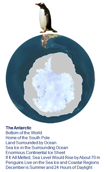
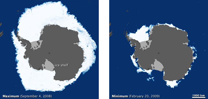
About 99% of
Antarctica is covered by snow and ice. The ice thickness reaches 4 km (2.4
miles) in some places. This ice flows off of the continent creating numerous
floating ice shelves where the flowing ice meets the ocean. These ice
shelves in turn give rise to many icebergs.
The Antarctic
ice cap contains about 70% of the planet’s fresh water and about 90% of its
ice.
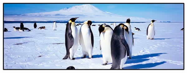
Penguins in front of Mount Erebus, Paul Rodgers New Zealand Defence Force
The southernmost
active volcano in the word, Mt. Erebus, forms an island at the edge of the
Ross Ice Shelf. This mountain rises more than 3,700 meters (12,100 feet)
above the surrounding Ross Sea and McMurdo Sound area. Two Antarctic
research stations, Scott Base (N.Z.) and McMurdo Station (U.S.) are located
on the southern tip of this volcanic island.
Almost all of
Antarctica lies within the Antarctic Circle (66°33’ South Latitude). All
points south of this imaginary line experience at least one day of 24-hour
daylight during summer and one day of 24-hour darkness in the winter.
Further south the periods of complete daylight and complete darkness last
much longer (up to about 4 months each per year)
There are no
countries in Antarctica, the continent is governed by an international
treaty
Antarctica has
no true permanent residents. Fewer than 1,000 people winter over in a given
year; the summer population is substantially higher as scientists and
support staff from over 27 countries converge on the continent.
The Antarctic Treaty
System is the whole complex of arrangements made for the purpose of regulating
relations among states in the Antarctic. At its heart is the Antarctic Treaty
itself. The original Parties to the Treaty were the 12 nations active in the
Antarctic during the International Geophysical Year of 1957-58. The Treaty was
signed in Washington on 1 December 1959 and entered into force on 23 June 1961.
The Consultative Parties comprise the original Parties and a further fourteen
States that have become Consultative Parties by acceding to the Treaty and
demonstrating their interest in Antarctica by carrying out substantial
scientific activity there.
The primary purpose
of the Antarctic Treaty is to ensure "in the interests of all mankind that
Antarctica shall continue forever to be used exclusively for peaceful purposes
and shall not become the scene or object of international discord." To this end
it prohibits military activity, except in support of science; prohibits nuclear
explosions and the disposal of nuclear waste; promotes scientific research and
the exchange of data; and holds all territorial claims in abeyance. The Treaty
applies to the area south of 60° South Latitude, including all ice shelves and
islands.
The Treaty is
augmented by Recommendations adopted at Consultative Meetings, by the Protocol
on Environmental Protection to the Antarctic Treaty (Madrid, 1991), and by two
separate conventions dealing with the Conservation of Antarctic Seals (London
1972), and the Conservation of Antarctic Marine Living Resources (Canberra
1980). The Convention on the Regulation of Antarctic Mineral Resource Activities
(Wellington 1988), negotiated between 1982 and 1988, will not enter into force.
Speculation over the existence of a "southern land" was not confirmed
until the early 1820s when British and American commercial operators
and British and Russian national expeditions began exploring the
Antarctic Peninsula region and other areas south of the Antarctic
Circle. Not until 1840 was it established that Antarctica was indeed a
continent and not just a group of islands. Several exploration
"firsts" were achieved in the early 20th century. Following World War
II, there was an upsurge in scientific research on the continent. A
number of countries have set up a range of year-round and seasonal
stations, camps, and refuges to support scientific research in
Antarctica. Seven have made territorial claims, but not all countries
recognize these claims. In order to form a legal framework for the
activities of nations on the continent, an Antarctic Treaty was
negotiated that neither denies nor gives recognition to existing
territorial claims; signed in 1959, it entered into force in 1961.
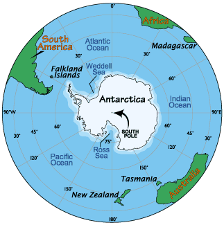
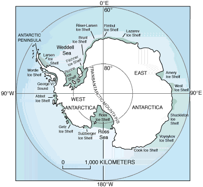
Geography
Antarctica
Location:
continent mostly south of the Antarctic Circle
Geographic
coordinates:
90 00 S, 0 00 E
Map references:
Antarctic Region
Area:
total:
14 million sq km land: 14 million sq km (280,000 sq km ice-free, 13.72 million
sq km ice-covered) (est.) note: fifth-largest continent, following Asia, Africa, North
America, and South America, but larger than Australia and the
subcontinent of Europe
Area - comparative:
slightly less than 1.5 times the size of the US
Land boundaries:
0 km note: see entry on Disputes - international
Coastline:
17,968 km
Maritime claims:
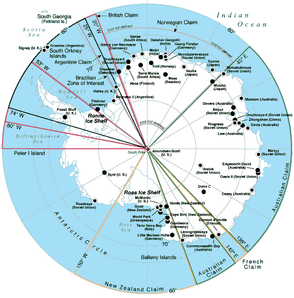
Australia, Chile, and Argentina claim Exclusive Economic Zone (EEZ)
rights or similar over 200 nm extensions seaward from their
continental claims, but like the claims themselves, these zones are
not accepted by other countries; 21 of 28 Antarctic consultative
nations have made no claims to Antarctic territory (although Russia
and the US have reserved the right to do so) and do not recognize the
claims of the other nations; also see the Disputes - international
entry
Climate:
severe low temperatures vary with latitude, elevation, and distance
from the ocean; East Antarctica is colder than West Antarctica because
of its higher elevation; Antarctic Peninsula has the most moderate
climate; higher temperatures occur in January along the coast and
average slightly below freezing
Terrain:
about 98% thick continental ice sheet and 2% barren rock, with average
elevations between 2,000 and 4,000 meters; mountain ranges up to
nearly 5,000 meters; ice-free coastal areas include parts of southern
Victoria Land, Wilkes Land, the Antarctic Peninsula area, and parts of
Ross Island on McMurdo Sound; glaciers form ice shelves along about
half of the coastline, and floating ice shelves constitute 11% of the
area of the continent
Elevation extremes:
lowest point: Bentley Subglacial Trench -2,540 m highest point: Vinson Massif 4,897 m note: the lowest known land point in Antarctica is hidden in
the Bentley Subglacial Trench; at its surface is the deepest ice yet
discovered and the world's lowest elevation not under seawater
Natural resources:
iron ore, chromium, copper, gold, nickel, platinum and other minerals,
and coal and hydrocarbons have been found in small uncommercial
quantities; none presently exploited; krill, finfish, and crab have
been taken by commercial fisheries
katabatic (gravity-driven) winds blow coastward from the high
interior; frequent blizzards form near the foot of the plateau;
cyclonic storms form over the ocean and move clockwise along the
coast; volcanism on Deception Island and isolated areas of West
Antarctica; other seismic activity rare and weak; large icebergs may
calve from ice shelf
Environment - current
issues:
in 1998, NASA satellite data showed that the Antarctic ozone hole was
the largest on record, covering 27 million square kilometers;
researchers in 1997 found that increased ultraviolet light passing
through the hole damages the DNA of icefish, an Antarctic fish lacking
hemoglobin; ozone depletion earlier was shown to harm one-celled
Antarctic marine plants; in 2002, significant areas of ice shelves
disintegrated in response to regional warming
Geography - note:
the coldest, windiest, highest (on average), and driest continent;
during summer, more solar radiation reaches the surface at the South
Pole than is received at the Equator in an equivalent period; mostly
uninhabitable
People
Antarctica
Population:
no indigenous inhabitants, but there are both permanent and
summer-only staffed research stations note: 28 nations, all signatory to the Antarctic Treaty,
operate through their National Antarctic Program a number of
seasonal-only (summer) and year-round research stations on the
continent and its nearby islands south of 60 degrees south latitude
(the region covered by the Antarctic Treaty); the population doing and
supporting science or engaged in the management and protection of the
Antarctic region varies from approximately 4,000 in summer to 1,000 in
winter; in addition, approximately 1,000 personnel, including ship's
crew and scientists doing onboard research, are present in the waters
of the treaty region; peak summer (December-February) population -
4,219 total; Argentina 667, Australia 200, Brazil 40, Bulgaria 15,
Chile 237, China 70, Czech Republic 20, Ecuador 26, Finland 20, France
100, France and Italy jointly 45, Germany 90, India 65, Italy 90,
Japan 125, South Korea 70, NZ 85, Norway 44, Peru 28, Poland 40,
Romania 3, Russia 429, South Africa 80, Spain 28, Sweden 20, Ukraine
24, UK 205, US 1,293, Uruguay 60 (2007-2008); winter (June-August)
station population - 1,088 total; Argentina 176, Australia 62, Brazil
12, Chile 96, China 29, France 26, France and Italy jointly 13,
Germany 9, India 25, Italy 2, Japan 40, South Korea 18, NZ 10, Norway
7, Poland 12, Russia 148, South Africa 10, Ukraine 12, UK 37, US 337,
Uruguay 9 (2008); research stations operated within the Antarctic
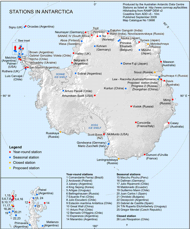
Treaty area (south of 60 degrees south latitude) by National Antarctic
Programs: year-round stations - 38 total; Argentina 6, Australia 3,
Brazil 1, Chile 4, China 2, France 1, France and Italy jointly 1,
Germany 1, India 1, Japan 1, South Korea 1, NZ 1, Norway 1, Poland 1,
Russia 5, South Africa 1, Ukraine 1, UK 2, US 3, Uruguay 1 (2008); a
range of seasonal-only (summer) stations, camps, and refuges -
Argentina, Australia, Bulgaria, Brazil, Chile, China, Czech Republic,
Ecuador, Finland, France, Germany, India, Italy, Japan, South Korea,
New Zealand, Norway, Peru, Poland, Romania, Russia, Spain, Sweden,
Ukraine, UK, US, and Uruguay (2007-2008); in addition, during the
austral summer some nations have numerous occupied locations such as
tent camps, summer-long temporary facilities, and mobile traverses in
support of research (March 2008 est.)
Government
Antarctica
Country name:
conventional long form: none conventional short form: Antarctica
Government type:
Antarctic Treaty Summary - the Antarctic Treaty, signed on 1 December
1959 and entered into force on 23 June 1961, establishes the legal
framework for the management of Antarctica; the 30th Antarctic Treaty
Consultative Meeting was held in Delhi, India in April/May 2007; at
these periodic meetings, decisions are made by consensus (not by vote)
of all consultative member nations; at the end of 2007, there were 46
treaty member nations: 28 consultative and 18 non-consultative;
consultative (decision-making) members include the seven nations that
claim portions of Antarctica as national territory (some claims
overlap) and 21 non-claimant nations; the US and Russia have reserved
the right to make claims; the US does not recognize the claims of
others; Antarctica is administered through meetings of the
consultative member nations; decisions from these meetings are carried
out by these member nations (with respect to their own nationals and
operations) in accordance with their own national laws; the years in
parentheses indicate when a consultative member-nation acceded to the
Treaty and when it was accepted as a consultative member, while no
date indicates the country was an original 1959 treaty signatory;
claimant nations are - Argentina, Australia, Chile, France, NZ,
Norway, and the UK. Nonclaimant consultative nations are - Belgium,
Brazil (1975/1983), Bulgaria (1978/1998) China (1983/1985), Ecuador
(1987/1990), Finland (1984/1989), Germany (1979/1981), India
(1983/1983), Italy (1981/1987), Japan, South Korea (1986/1989),
Netherlands (1967/1990), Peru (1981/1989), Poland (1961/1977), Russia,
South Africa, Spain (1982/1988), Sweden (1984/1988), Ukraine
(1992/2004), Uruguay (1980/1985), and the US; non-consultative
members, with year of accession in parentheses, are - Austria (1987),
Belarus (2006), Canada (1988), Colombia (1989), Cuba (1984), Czech
Republic (1962/1993), Denmark (1965), Estonia (2001), Greece (1987),
Guatemala (1991), Hungary (1984), North Korea (1987), Papua New Guinea
(1981), Romania (1971), Slovakia (1962/1993), Switzerland (1990),
Turkey (1996), and Venezuela (1999); note - Czechoslovakia acceded to
the Treaty in 1962 and separated into the Czech Republic and Slovakia
in 1993; Article 1 - area to be used for peaceful purposes only;
military activity, such as weapons testing, is prohibited, but
military personnel and equipment may be used for scientific research
or any other peaceful purpose; Article 2 - freedom of scientific
investigation and cooperation shall continue; Article 3 - free
exchange of information and personnel, cooperation with the UN and
other international agencies; Article 4 - does not recognize, dispute,
or establish territorial claims and no new claims shall be asserted
while the treaty is in force; Article 5 - prohibits nuclear explosions
or disposal of radioactive wastes; Article 6 - includes under the
treaty all land and ice shelves south of 60 degrees 00 minutes south
and reserves high seas rights; Article 7 - treaty-state observers have
free access, including aerial observation, to any area and may inspect
all stations, installations, and equipment; advance notice of all
expeditions and of the introduction of military personnel must be
given; Article 8 - allows for jurisdiction over observers and
scientists by their own states; Article 9 - frequent consultative
meetings take place among member nations; Article 10 - treaty states
will discourage activities by any country in Antarctica that are
contrary to the treaty; Article 11 - disputes to be settled peacefully
by the parties concerned or, ultimately, by the ICJ; Articles 12, 13,
14 - deal with upholding, interpreting, and amending the treaty among
involved nations; other agreements - some 200 recommendations adopted
at treaty consultative meetings and ratified by governments include -
Agreed Measures for Fauna and Flora (1964) which were later
incorporated into the Environmental Protocol; Convention for the
Conservation of Antarctic Seals (1972); Convention on the Conservation
of Antarctic Marine Living Resources (1980); a mineral resources
agreement was signed in 1988 but remains unratified; the Protocol on
Environmental Protection to the Antarctic Treaty was signed 4 October
1991 and entered into force 14 January 1998; this agreement provides
for the protection of the Antarctic environment through six specific
annexes: 1) environmental impact assessment, 2) conservation of
Antarctic fauna and flora, 3) waste disposal and waste management, 4)
prevention of marine pollution, 5) area protection and management and
6) liability arising from environmental emergencies; it prohibits all
activities relating to mineral resources except scientific research; a
permanent Antarctic Treaty Secretariat was established in 2004 in
Buenos Aires, Argentina
Legal system:
Antarctica is administered through meetings of the consultative member
nations; decisions from these meetings are carried out by these member
nations (with respect to their own nationals and operations) in
accordance with their own national laws; more generally, access to the
Antarctic Treaty area, that is to all areas between 60 and 90 degrees
south latitude, is subject to a number of relevant legal instruments
and authorization procedures adopted by the states party to the
Antarctic Treaty; note - US law, including certain criminal offenses
by or against US nationals, such as murder, may apply
extraterritorially; some US laws directly apply to Antarctica; for
example, the Antarctic Conservation Act, 16 U.S.C. section 2401 et
seq., provides civil and criminal penalties for the following
activities unless authorized by regulation of statute: the taking of
native mammals or birds; the introduction of nonindigenous plants and
animals; entry into specially protected areas; the discharge or
disposal of pollutants; and the importation into the US of certain
items from Antarctica; violation of the Antarctic Conservation Act
carries penalties of up to $10,000 in fines and one year in prison;
the National Science Foundation and Department of Justice share
enforcement responsibilities; Public Law 95-541, the US Antarctic
Conservation Act of 1978, as amended in 1996, requires expeditions
from the US to Antarctica to notify, in advance, the Office of Oceans,
Room 5805, Department of State, Washington, DC 20520, which reports
such plans to other nations as required by the Antarctic Treaty; for
more information, contact Permit Office, Office of Polar Programs,
National Science Foundation, Arlington, Virginia 22230; telephone:
(703) 292-8030, or visit its website at www.nsf.gov
Economy
Antarctica
Economy - overview:
Fishing off the coast and tourism, both based abroad, account for
Antarctica's limited economic activity. Antarctic fisheries in 2005-06
(1 July-30 June) reported landing 128,081 metric tons (estimated
fishing from the area covered by the Convention on the Conservation of
Antarctic Marine Living Resources (CCAMLR), which extends slightly
beyond the Antarctic Treaty area). Unregulated fishing, particularly
of Patagonian toothfish (Dissostichus eleginoides), is a serious
problem. The CCAMLR determines the recommended catch limits for marine
species. A total of 36,460 tourists visited the Antarctic Treaty area
in the 2006-07 Antarctic summer, up from the 30,877 visitors the
previous year (estimates provided to the Antarctic Treaty by the
International Association of Antarctica Tour Operators (IAATO); this
does not include passengers on overflights). Nearly all of them were
passengers on commercial (nongovernmental) ships and several yachts
that make trips during the summer. Most tourist trips last
approximately two weeks.
Communications
Antarctica
Telephones - main
lines in use:
0; note - information for US bases only (2001)
Telephone system:
general assessment: local systems at some research stations domestic: commercial cellular networks operating in a small
number of locations international: country code - none allocated; via satellite
(including mobile Inmarsat and Iridium systems) to and from all
research stations, ships, aircraft, and most field parties (2007)
Radio broadcast
stations:
FM 2, shortwave 1 (information for US bases only); note - many
research stations have a local FM radio station (2007)
Radios:
NA
Television broadcast
stations:
1 (cable system with 6 channels; American Forces Antarctic
Network-McMurdo - information for US bases only) (2002)
Televisions:
several hundred at McMurdo Station (US) note: information for US bases only (2001)
Internet country code:
.aq
Internet hosts:
7,748 (2008)
Internet Service
Providers (ISPs):
NA
Transportation
Antarctica
Airports:
25 (2008)
Airports - with
unpaved runways:
total:
25 over 3,047 m: 4 2,438 to 3,047 m: 5 1,524 to 2,437 m: 1 914 to 1,523 m: 9 under 914 m: 6 (2008)
Heliports:
53 note: all year-round and seasonal stations operated by
National Antarctic Programs stations have some kind of helicopter
landing facilities, prepared (helipads) or unprepared (2007)
Ports and terminals:
there are no developed ports and harbors in Antarctica; most coastal
stations have offshore anchorages, and supplies are transferred from
ship to shore by small boats, barges, and helicopters; a few stations
have a basic wharf facility; US coastal stations include McMurdo (77
51 S, 166 40 E), and Palmer (64 43 S, 64 03 W); government use only
except by permit (see Permit Office under "Legal System"); all ships
at port are subject to inspection in accordance with Article 7,
Antarctic Treaty; offshore anchorage is sparse and intermittent;
relevant legal instruments and authorization procedures adopted by the
states parties to the Antarctic Treaty regulating access to the
Antarctic Treaty area, to all areas between 60 and 90 degrees of
latitude south, have to be complied with (see "Legal System"); The
Hydrographic Committee on Antarctica (HCA), a special hydrographic
commission of International Hydrographic Organization (IHO), is
responsible for hydrographic surveying and nautical charting matters
in Antarctic Treaty area; it coordinates and facilitates provision of
accurate and appropriate charts and other aids to navigation in
support of safety of navigation in region; membership of HCA is open
to any IHO Member State whose government has acceded to the Antarctic
Treaty and which contributes resources and/or data to IHO Chart
coverage of the area; members of HCA are Argentina, Australia, Brazil,
Chile, China, Ecuador, France, Germany, Greece, India, Italy, NZ,
Norway, Russia, South Africa, Spain, UK, and US (2007)
Military
Antarctica
Military - note:
the Antarctic Treaty prohibits any measures of a military nature, such
as the establishment of military bases and fortifications, the
carrying out of military maneuvers, or the testing of any type of
weapon; it permits the use of military personnel or equipment for
scientific research or for any other peaceful purposes
Transnational Issues
Antarctica
Disputes -
international:
the Antarctic Treaty freezes, and most states do not recognize, the
land and maritime territorial claims made by Argentina, Australia,
Chile, France, New Zealand, Norway, and the United Kingdom (some
overlapping) for three-fourths of the continent; the US and Russia
reserve the right to make claims; no claims have been made in the
sector between 90 degrees west and 150 degrees west; the International
Whaling Commission created a sancturary around the entire continent to
deter catches by countries claiming to conduct scientific whaling;
Australia has established a similar preserve in the waters around its
territorial claim
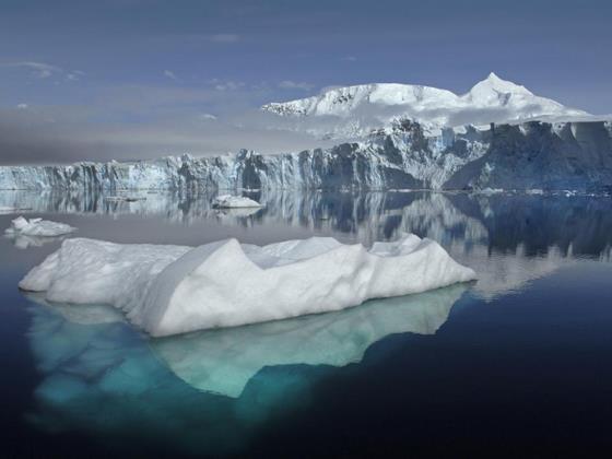
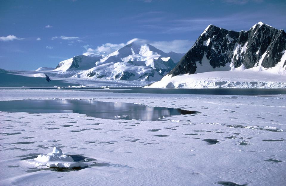
View of Sheldon Glacier with Mount Barre in the background, seen from Ryder Bay
near Rothera Research Station, Adelaide Island, Antarctica. Image credit:
British Antarctic Survey
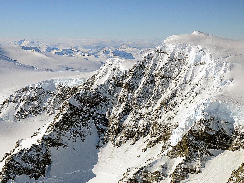
The landscape of
Alexander Island, Antarctica, as seen by NASA's DC-8 on Oct. 24, 2011. Credit:
NASA/Michael Studinger
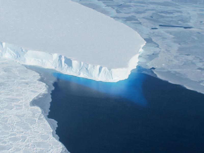
The calving front of
Thwaites Ice Shelf looking at the ice below the water's surface. Note how the
water acts as a blue filter. Credit: NASA / Jim Yungel
Credit: British Antarctic
Survey, New Zealand Antarctic Program, Seal Conservation Society, U.K. Royal
Navy, The BBC, Northeastern University,NOAA,CIA,NASA