About Earthly Issues Contact

Site Map

Donate

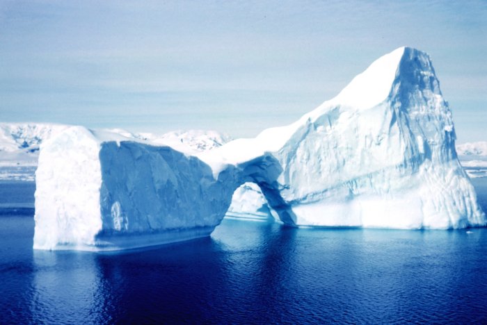
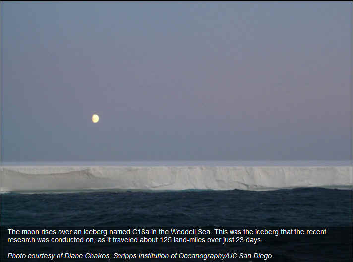
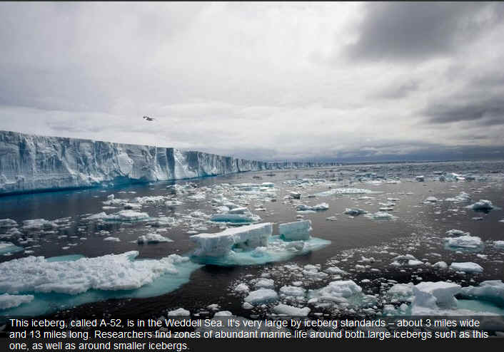
Icebergs of the Antarctic

Photographer: Rear Admiral Harley D. Nygren, NOAA Corps

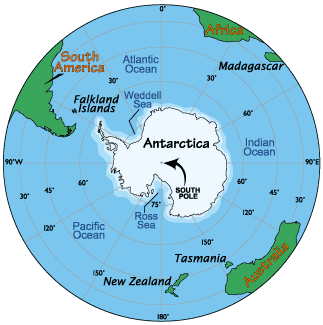
Map from Worldatlas.com


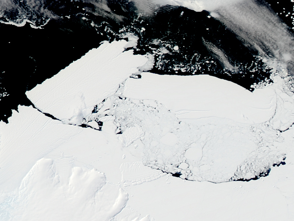
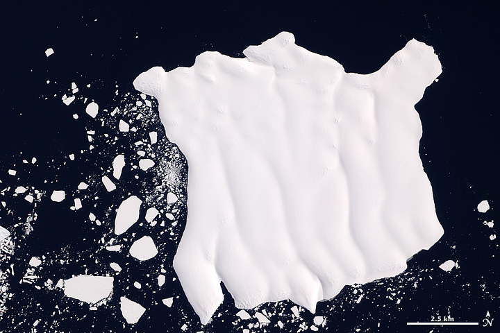
An oblong iceberg roughly as big as Rhode Island called B-09B (center right in this image) collided with the edge of the Mertz Glacier in eastern Antarctica this month breaking away a new iceberg (top left) that is nearly as large at B-09B. This image from Feb. 20, 2010, is one of a series of images from NASA's Aqua satellite that showed the progression and aftermath of the collision. The floating ice tongue of the glacier is created as ice flows down from Antarctica and onto the water. Glacier tongues grow longer year by year until they eventually break off, calving a new iceberg.

Image Credit: NASA


antarctica

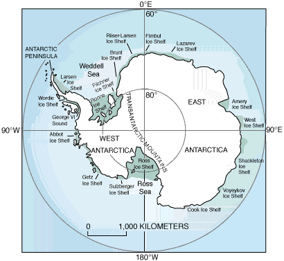
Iceberg names are derived from the Antarctic quadrant in which they were originally sighted. The quadrants are divided counter-clockwise in the following manner:

  • A = 0-90W (Bellinghausen/Weddell Sea)

  • B = 90W-180 (Amundsen/Eastern Ross Sea)

  • C = 180-90E (Western Ross Sea/Wilkesland)

  • D = 90E-0 (Amery/Eastern Weddell Sea)


When an iceberg is first sighted, The National Ice Center documents its point of origin. The letter of the quadrant, along with a sequential number is assigned to the iceberg. 

Iceberg off Mertz Glacier Tongue NASA Earth Observatory image by Jesse Allen, using EO-1


http://www.natice.noaa.gov


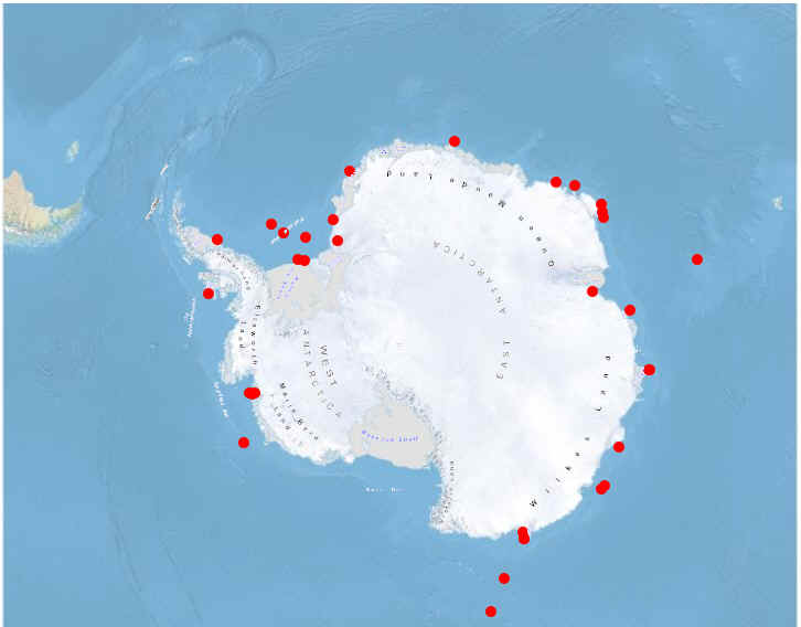
Antarctic Icebergs 

CURRENT POSITIONS 

National Ice Center (NIC) Chart

http://www.natice.noaa.gov/products/south_icebergs.html


http://www.natice.noaa.gov/products/south_icebergs_on_demand.html

 
Iceberg
(Click for
Image)
Date
Updated
Image
Source for
Update
Latitude Longitude Size
(NM)
A23A 02-12-2012 ENVISAT -75.90705566 S -41.40235276 W 45X36
A56 02-12-2012 ENVISAT -77.0539471 S -50.21847317 W 14X7
A57 02-12-2012 ENVISAT -77.59522694 S -48.63216119 W 19X5
A61 02-12-2012 MODIS -72.20717247 S -16.00710861 W 14X4
A62 02-12-2012 ENVISAT -69.24872578 S -44.47497141 W 13X5
B09B 02-12-2012 MODIS -66.66545141 S 142.83126107 E 30X11
B09C 02-12-2012 MODIS -64.84513003 S 116.40221268 E 13X3
B09D 02-12-2012 MODIS -66.2691216 S 143.10579717 E 32X6
B09F 02-12-2012 MODIS -65.73973917 S 142.08384555 E 21X7
B15B 02-12-2012 ENVISAT -65.28559392 S -40.87514836 W 18X3
B15F 02-12-2012 ENVISAT -67.14328805 S -49.17161314 W 18X5
B15G 02-12-2012 ENVISAT -68.16347915 S 35.45048415 E 19X9
B15K 02-12-2012 ENVISAT -77.66909301 S -35.37600095 W 29X2
B15R 02-12-2012 ENVISAT -67.62293199 S 44.0544033 E 11X2
B15T 02-12-2012 MODIS -65.84698554 S 57.15172234 E 38X11
B15X 02-12-2012 MODIS -68.87741158 S 30.06821688 E 11X6
B16 02-12-2012 MODIS -65.41882915 S 116.47105027 E 16X6
B17A 02-12-2012 MODIS -69.62377428 S 27.09595843 E 19X6
B22A 02-12-2012 ENVISAT -74.17709338 S -108.87255542 W 44X24
B27 02-12-2012 ENVISAT -74.00919137 S -144.71315886 W 10X6
B28 02-12-2012 ENVISAT -74.80771088 S -109.06041087 W 10X7
B29 02-12-2012 ENVISAT -74.6544852 S -109.12576603 W 11X4
C15 02-12-2012 MODIS -67.48637905 S 146.39968907 E 16X8
C16 02-12-2012 ENVISAT -71.19586957 S -30.13687459 W 23X7
C18B 02-12-2012 MODIS -65.67121525 S 113.82872738 E 19X4
C19C 02-12-2012 ENVISAT -62.22584782 S -53.79251312 W 21X12
C21B 02-12-2012 MODIS -65.00626841 S 95.90189685 E 13X9
C24 02-12-2012 MODIS -64.84862555 S 96.01868346 E 11X2
C28A 02-12-2012 MODIS -65.73976817 S 79.20766793 E 27X19
C28B 02-12-2012 MODIS -65.74639081 S 116.26599319 E 21X17
D14 02-12-2012 ENVISAT -69.42444033 S 74.99871642 E 13X8
D15 02-12-2012 MODIS -66.762197 S 81.88967049 E 55X29
D20 02-12-2012 ENVISAT -69.13136355 S 36.45043981 E 28X11

http://www.natice.noaa.gov/products/antarctic_icebergs.html


The National Ice Center is a tri-agency operational center represented by the United States Navy (Department of Defense); the National Oceanic and Atmospheric Administration Department of Commerce); and the United States Coast Guard (Department of Transportation). The National Ice Center mission is to provide world-wide operational ice analyses for the armed forces of the United States and allied nations, U.S. government agencies, and the private sector.


http://nsidc.org/index.html


http://www.navcen.uscg.gov


http://www.natice.noaa.gov

 Credit: U.S. Coast Guard, The National Ice Center, Royal New Zealand Air Force,NOAA


Data compiled from The British Antarctic Study, NASA, Environment Canada, UNEP, EPA and other sources as stated and credited Researched by Charles Welch-Updated daily This Website is a project of the The Ozone Hole Inc. a 501(c)(3) Nonprofit Organization http://www.theozonehole.com

Visit our other site

Charles Welch

An Up A Tree Again Production

© Charles Welch 2013

Privacy Policy