|
||||||||||||
|
|
|
Glaciers and Ice Sheets
Glaciers are made up of fallen snow that, over many years, compresses into large, thickened ice masses. Glaciers form when snow remains in one location long enough to transform into ice. What makes glaciers unique is their ability to move. Due to sheer mass, glaciers flow like very slow rivers. Some glaciers are as small as football fields, while others grow to be over a hundred kilometers long.
Presently, glaciers occupy about 10 percent of the world's total land area, with most located in polar regions like Antarctica and Greenland. Glaciers can be thought as remnants from the last Ice Age, when ice covered nearly 32 percent of the land, and 30 percent of the oceans. An Ice Age occurs when cool temperature endure for extended periods of time, allowing polar ice to advance into lower latitudes. For example, during the last Ice Age, giant glacial ice sheets extended from the poles to cover most of Canada, all of New England, much of the upper Midwest, large areas of Alaska, most of Greenland, Iceland, Svalbard and other arctic islands, Scandinavia, much of Great Britain and Ireland, and the northwestern part of the former Soviet Union. Within the past 750,000 years, scientists know that there have been eight Ice Age cycles, separated by warmer periods called interglacial periods.
Ice sheets and glaciers form the largest component of perennial ice on Earth. Over 75% of the world's fresh water is presently locked up in these frozen reservoirs. A Glacier is any large mass of perennial ice that originates on land by the recrystallization of snow or other forms of solid precipitation and that shows evidence of past or present flow. A glacier occupying an extensive tract of relatively level land and exhibiting flow from the center outward is commonly called an ice sheet. Glaciers form when snow accumulates on a patch of land over tens to hundreds of years. The snow eventually becomes so thick that it collapses under its own weight and forms dense glacial ice. When enough of the ice is compacted together it succumbs to gravity and begins to flow downhill or spread out across flat lands. What makes glaciers unique is their ability to move. Due to sheer mass, glaciers flow like very slow rivers. More than 90 percent of the 33 million cubic kilometers of glacier ice in the world is locked up in the gigantic Greenland and Antarctic ice sheets. NASA: A Short Tour of the Cryosphere Video Most of the world's glaciers are found near the Poles, but glaciers exist on all of the world's continents, even Africa. Australia doesn't have any glaciers; however, it is considered part of Oceania, which includes several Pacific island chains and the large islands of Papua New Guinea and New Zealand. Both of these islands have glaciers. Glaciers require very specific climatic conditions. Most are found in regions of high snowfall in winter and cool temperatures in summer. These conditions ensure that the snow that accumulates in the winter isn't lost (by melt, evaporation, or calving) during the summer. Such conditions typically prevail in polar and high alpine regions. There are two main types of glaciers: valley glaciers and continental glaciers (known as ice sheets). The amount of precipitation (whether in the form of snowfall, freezing rain, avalanches, or wind-drifted snow) is important to glacier survival. In areas such as Antarctica, where the low temperatures are ideal for glacier growth, very low annual precipitation causes the glaciers to grow very slowly. Motion and change define a glacier's life. Glacial ice advances, then retreats. Glaciers grow and shrink in response to changing climate.
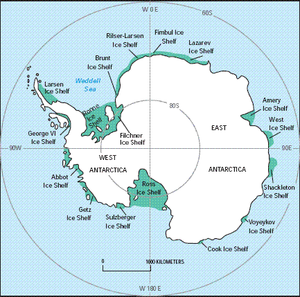
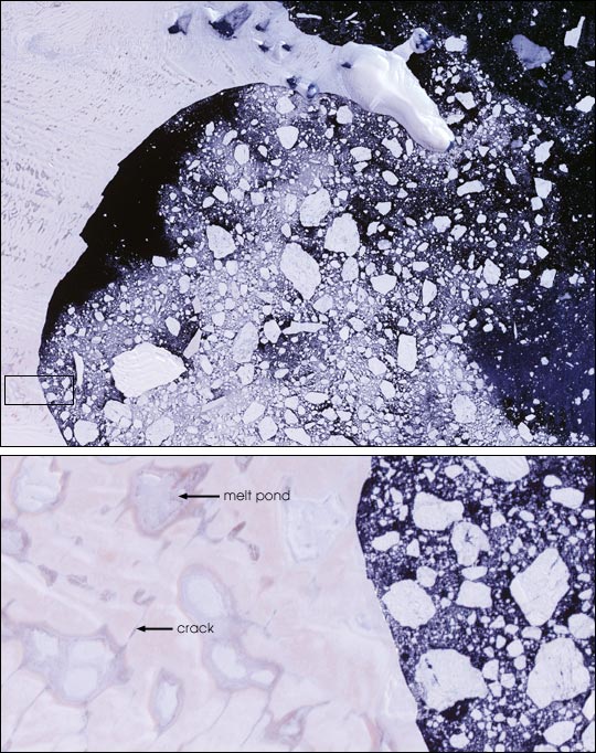
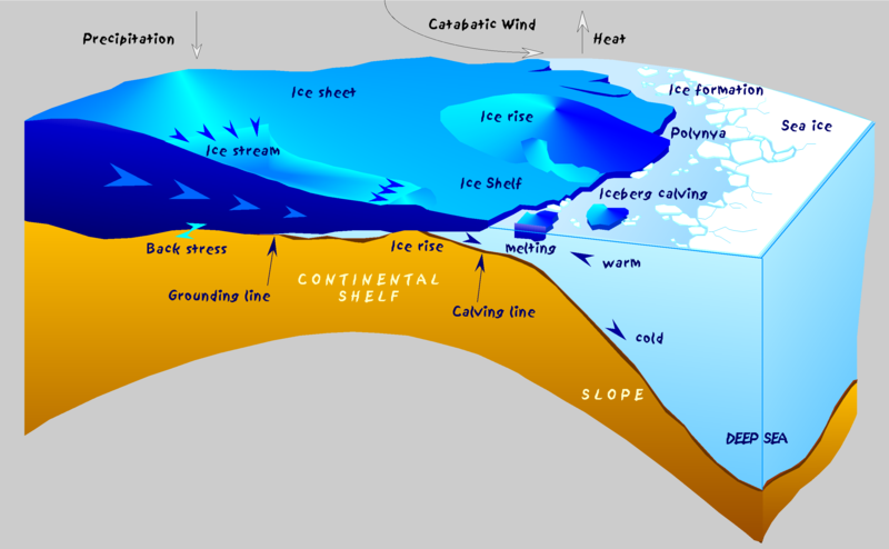
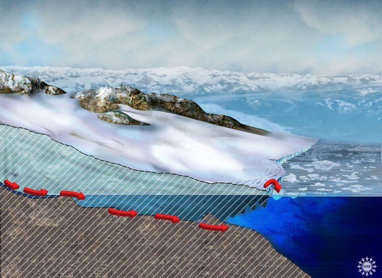
The ice cover in Greenland and Antarctica has two components – thick, grounded, inland ice that rests on a more or less solid bed, and thinner floating ice shelves and glacier tongues. An ice sheet is actually a giant glacier, and like most glaciers it is nourished by the continual accumulation of snow on its surface. As successive layers of snow build up, the layers beneath are gradually compressed into solid ice. Snow input is balanced by glacial outflow, so the height of the ice sheet stays approximately constant through time. The ice is driven by gravity to slide and to flow downhill from the highest points of the interior to the coast. There it either melts or is carried away as icebergs which also eventually melt, thus returning the water to the ocean whence it came. Outflow from the inland ice is organized into a series of drainage basins separated by ice divides that concentrate the flow of ice into either narrow mountain-bounded outlet glaciers or fast-moving ice streams surrounded by slow-moving ice rather than rock walls. In Antarctica much of this flowing ice has reached the coast and has spread over the surface of the ocean to form ice shelves that are floating on the sea but are attached to ice on land. There are ice shelves along more than half of Antarctica’s coast, but very few in Greenland.
Ice Sheets
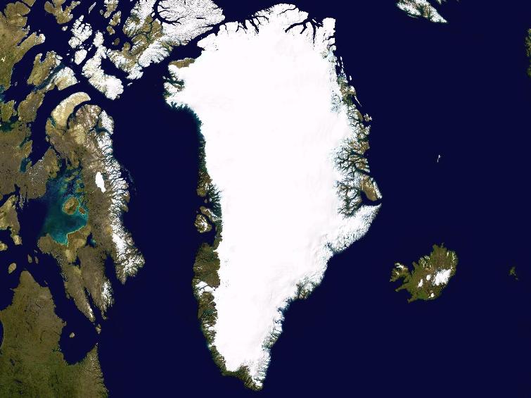
Greenland Credit:NASA An ice sheet is a mass of glacial land ice extending more than 50,000 square kilometers (20,000 square miles). The two ice sheets on Earth today cover most of Greenland and Antarctica. During the last ice age, ice sheets also covered much of North America and Scandinavia. Together, the Antarctic and Greenland ice sheets contain more than 99 percent of the freshwater ice on Earth. The Antarctic Ice Sheet extends almost 14 million square kilometers (5.4 million square miles), roughly the area of the contiguous United States and Mexico combined. The Antarctic Ice Sheet contains 30 million cubic kilometers (7.2 million cubic miles) of ice. The Greenland Ice Sheet extends about 1.7 million square kilometers (656,000 square miles), covering most of the island of Greenland, three times the size of Texas. Ice sheets form in areas where snow that falls in winter does not melt entirely over the summer. Over thousands of years, the layers of snow pile up into thick masses of ice, growing thicker and denser as the weight of new snow and ice layers compresses the older layers. Ice sheets are constantly in motion, slowly flowing downhill under their own weight. Near the coast, most of the ice moves through relatively fast-moving outlets called ice streams, glaciers, and ice shelves. As long as an ice sheet accumulates the same mass of snow as it loses to the sea, it remains stable.
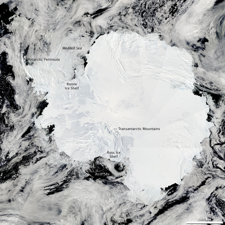
Antarctica-The Moderate Resolution Imaging Spectroradiometer (MODIS) on NASA’s Aqua satellite captured this composite image on January 27, 2009
Ice sheets contain enormous quantities of frozen water. If the Greenland Ice Sheet melted, scientists estimate that sea level would rise about 6 meters (20 feet). If the Antarctic Ice Sheet melted, sea level would rise by about 60 meters (200 feet). The Greenland and Antarctic ice sheets also influence weather and climate. Large high-altitude plateaus on the ice caps alter storm tracks and create cold downslope winds close to the ice surface. In addition, the layers of ice blanketing Greenland and Antarctica contain a unique record of Earth’s climate history. The mass of ice in the Greenland Ice Sheet has begun to decline. From 1979 to 2006, summer melt on the ice sheet increased by 30 percent, reaching a new record in 2007. At higher elevations, an increase in winter snow accumulation has partially offset the melt. However, the decline continues to outpace accumulation because warmer temperatures have led to increased melt and faster glacier movement at the island's edges. Most of Antarctica has yet to see dramatic warming. However, the Antarctic Peninsula, which juts out into warmer waters north of Antarctica, has warmed 2.5 degrees Celsius (4.5 degrees Fahrenheit) since 1950. A large area of the West Antarctic Ice Sheet is also losing mass, probably because of warmer water deep in the ocean near the Antarctic coast. In East Antarctica, no clear trend has emerged, although some stations appear to be cooling slightly. Overall, scientists believe that Antarctica is starting to lose ice, but so far the process has not become as quick or as widespread as in Greenland.
Ice Shelves
Ice shelves are permanent floating sheets of ice that connect to a landmass. Most of the world’s ice shelves hug the coast of Antarctica. However, ice shelves can also form wherever ice flows from land into cold ocean waters, including some glaciers in the Northern Hemisphere.
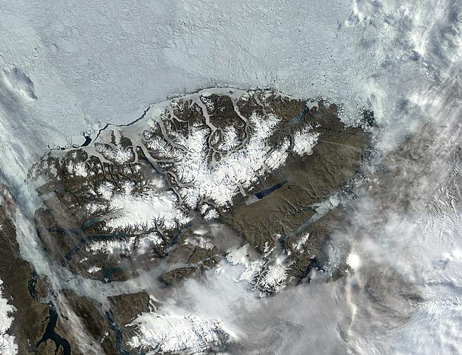
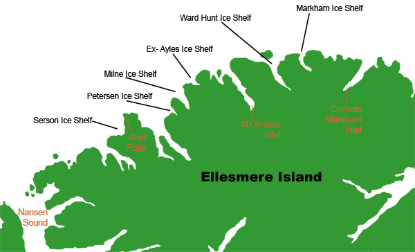
Ellesmere Island, Northern Canada Credit: Jacques Descloitres, MODIS Rapid Response Team, NASA/GSFC The northern coast of Canada's Ellesmere Island is home to several well-known ice shelves, among them the Markham and the Ward Hunt ice shelves.
Ice from enormous ice sheets slowly oozes into the sea through glaciers and ice streams. If the ocean is cold enough, that newly arrived ice doesn't melt right away. Instead it may float on the surface and grow larger as glacial ice behind it continues to flow into the sea. Along protected coastlines, the resulting ice shelves can survive for thousands of years, bolstered by the rock of peninsulas and islands. Ice shelves grow when they gain ice from land, and occasionally shrink when icebergs calve off their edges. This give and take helps them maintain a dynamic stability. Because ice shelves already float in the ocean, they do not contribute directly to sea level rise when they break up. However, ice shelf collapse could contribute to sea level rise indirectly. Ice streams and glaciers constantly push on ice shelves, but the shelves eventually come up against coastal features such as islands and peninsulas, building pressure that slows their movement into the ocean. If an ice shelf collapses, the backpressure disappears. The glaciers that fed into the ice shelf speed up, flowing more quickly out to sea. Glaciers and ice sheets rest on land, so once they flow into the ocean, they contribute to sea level rise. Research suggests that glaciers behind ice shelves may accelerate by as much as five times following a rapid ice shelf retreat.
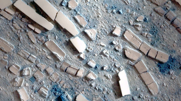
This satellite image shows floating chunks of ice from the 2008 Wilkins Ice Shelf collapse. —Credit: National Snow & Ice Data Center
The Wilkins Ice Shelf Credit: Mark Terry http://www.theantarcticachallenge.com In the last thirty years, scientists have observed a series of unusual ice shelf collapses on the Antarctic Peninsula. Although it is not unusual for ice shelves to calve large icebergs, that process normally takes months to years, as cracks slowly form in the ice. Following a calving, ice shelves generally recover over a period of decades. In recent years, ice shelves on the Antarctic Peninsula and along the northern coast of Canada have experienced rapid disintegration. In March 2008, the Wilkins Ice Shelf in Antarctica retreated by nearly 1,100 square kilometers (425 square miles). Later that summer, several ice shelves along Ellesmere Island in Northern Canada broke up in a matter of days. In contrast, the collapses in previous years happened over a period of weeks, leaving a soup of chunky ice and small icebergs. The remaining ice shelves retreated by as much as 90 percent, and several have experienced repeated collapses. Scientists think that the recent ice shelf collapses in both the Arctic and Antarctica are related to climate change. Most of the rapidly retreating ice shelves in Antarctica are located on the Antarctic Peninsula. The Antarctic Peninsula juts north towards South America, into warmer waters. The peninsula has warmed 2.5 degrees Celsius (4.5 degrees Fahrenheit) since 1950, making it one of the fastest-warming places on Earth. Scientists attributed rapid ice shelf collapse to warmer air and water temperatures, as well asincreased melt on the ice shelf surface. Retreating sea ice may also play a role. Warm air melts the ice shelf surface, forming ponds of meltwater. As the water trickles down through small cracks in the ice shelf, it deepens, erodes, and expands those cracks. In a separate process, warmer water melts the ice shelf from below, thinning it and making it more vulnerable to cracking. Scientists have observed both processes in all the ice shelves that have rapidly retreated in recent years. However, warm temperatures alone do not fully explain rapid ice shelf collapse. Recent research suggests that waning sea ice surrounding the Antarctic Peninsula and the Arctic ice shelves in Canada might also have contributed to the recent collapses. Sea ice provides a layer of protection between an ice shelf and the surrounding ocean, muting the power of large waves and storms. As sea ice decreases, more waves buffet the ice shelves. The largest waves can buckle and bend an ice shelf, increasing instability and possibly contributing to a collapse.
Larsen Ice Shelf, Antarctica Landsat 7 Science Team and NASA GSFC Satellite: Landsat 7 Sensor: ETM+
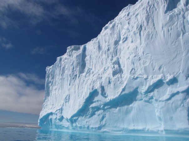
Ice shelves occur when ice sheets extend over the sea, floating on the water. In thickness they range from a few hundred meters to over 1000 meters. Ice shelves surround nearly all of the Antarctic continent. Retreating ice shelves may provide indications of climate change.
Credit:Hannes Grobe, Alfred Wegener Institute for Polar and Marine Research, Bremerhaven, Germany
Ice Caps Ice caps are miniature ice sheets. An ice cap covers less than 50,000 square kilometers. They form primarily in polar and sub-polar regions that are relatively flat and high in elevation.
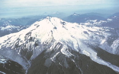
Mountain Glacier
Glacier Peak North Cascade Mountains USGS Photograph These glaciers develop in high mountainous regions, often flowing out of icefields that span several peaks or even a mountain range. The largest mountain glaciers are found in Arctic Canada, Alaska, the Andes in South America, the Himalayas in Asia, and on Antarctica. Valley Glacier
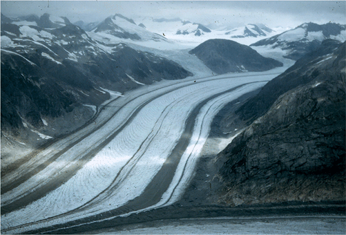
Northeast-looking oblique aerial photograph of the upper part of the Bucher Glacier, an outlet glacier of the Juneau Icefield, Coast Mountains, Tongass National Forest, Alaska. The length of the glacier shown is ~ 5 miles
Commonly originating from mountain glaciers or ice fields, these glaciers spill down valleys, looking much like giant tongues. Valley glaciers may be very long, often flowing down beyond the snow line, sometimes reaching sea level.
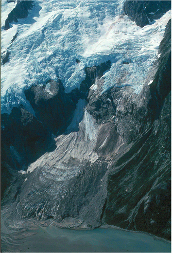
Calving Glacier
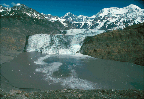
The calving terminus of Tyndall Glacier, located at the head of Taan Fiord, Icy Bay, Wrangell - St. Elias National Park, Alaska. The large mountain to the right is Mt. St. Elias.
A glacier with a terminus that ends in a body of water (river, lake, ocean) into which it calves icebergs.
Piedmont Glacier
Malaspina Glacier NASA Space Shuttle Photograph
Piedmont glaciers occur when steep valley glaciers spill into relatively flat plains, where they spread out into bulb-like lobes. The Malaspina Glacier in Alaska, covering over 5,000 square kilometers is one of the most famous examples of this type of glacier.
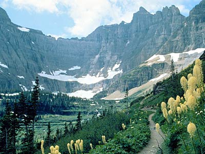
Cirque Glacier
Glacier National Park Cirque Glaciers are named for the bowl-like hollows they occupy, which are called cirques. Typically, they are found high on mountainsides and tend to be wide rather than long.
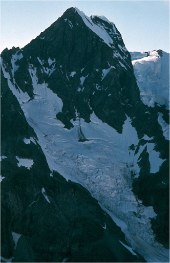
Hanging Glacier
North-looking oblique aerial photograph showing a small, unnamed hanging glacier located in the Chugach Mountains, near Cordova Peak, Chugach National Forest, Alaska.
Also called ice aprons, these glaciers cling to steep mountainsides. Like cirque glaciers, they are wider than they are long. Hanging glaciers are common in the Alps, where they often cause avalanches due to the steep inclines they occupy.
Reconstituted Glacier
Southwest-looking oblique aerial photograph of the reconstituted Ogive Glacier, located on the shore of Northwestern Fjord, Kenai Fjords National Park, Kenai Mountains, Alaska
A glacier formed below the terminus of a hanging glacier by the accumulation, and reconstitution by pressure melting (regelation), of ice blocks that have fallen and/or avalanched from the terminus of the hanging glacier. Also called Glacier Remanié.
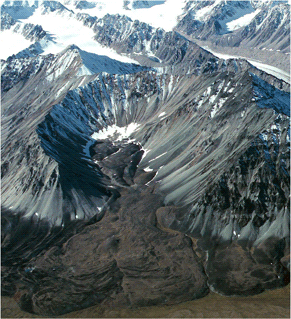
Rock Glacier
Northwest-looking oblique aerial photograph of an unnamed rock glacier heading in a cirque, located on the southeast side of the Talkeetna Mountains, Alaska
A glacier-like landform that often heads in a cirque and consists of a valley-filling accumulation of angular rock blocks. Rock glaciers have little or no visible ice at the surface. Ice may fill the spaces between rock blocks. Some rock glaciers move, although very slowly.
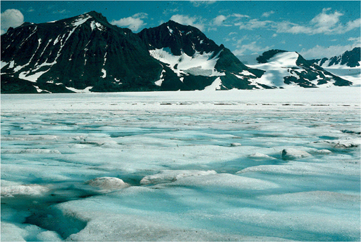
Temperate Glacier
Northeast-looking photograph showing the stream and pond covered-surface of the Taku Glacier, Juneau Icefield, Tongas National Forest, Coast Mountains, Alaska
A glacier with a or temperature-regime in which liquid water coexists with frozen water (glacier ice) during part or even all of the year
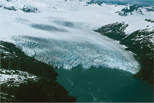
Tidewater Glacier
Northwest-looking oblique aerial photograph of the tidewater terminus of the calving Chenega Glacier, located at sea level in western Prince William Sound, Kenai Mountains, Alaska
As the name implies, these are valley glaciers that flow far enough to reach out into the sea. Tidewater glaciers are responsible for calving numerous small icebergs, while not as imposing as Antarctic icebergs, can still pose problems for shipping lanes.
When a glacier with its "toe in the water" thins, a larger fraction of its weight is supported by water and it slides faster and calves more ice into the ocean at the glacier terminus.
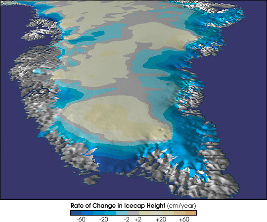
Greenland
Credit: NASA GSFC Scientific Visualization Studio Data Source: Airborne Topographic Mapper
A NASA study of Greenland’s ice sheet reveals that it is rapidly thinning. In an article published in the Magazine Science, Bill Krabill, project scientist at the NASA Goddard Space Flight Center’s Wallops Flight Facility, Wallops Island, VA, reports that the frozen area around Greenland is thinning, in some places, at a rate of more than three feet per year. Any change is important since a smaller ice sheet could result in higher sea levels. “A conservative estimate, based on our data, indicates a net loss of approximately 51 cubic kilometers of ice per year from the entire ice sheet, sufficient to raise global sea level by 0.005 inches per year, or approximately seven percent of the observed rise,” Krabill said. “This amount of sea level rise does not threaten coastal regions, but these results provide evidence that the margins of the ice sheet are in a process of change,” Krabill said. “The thinning cannot be accounted for by increased melting alone. It appears that ice must be flowing more quickly into the sea through glaciers.”
Polar ice reflects a great deal of the Sun's energy that falls on it back into space, helping regulate the amount of energy arriving on Earth, which drives weather and all the other atmospheric activities. Even a few percent more acres of open water absorbing energy could tip the scales of Earth's energy balance, adding more energy to the atmosphere, altering short- and long-term weather patterns.
redit: NASA , UNEP, NSIDC,USGS |